
Decatur County, Indiana facts for kids
Quick facts for kids
Decatur County
|
|
|---|---|
.jpg)
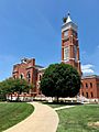
Decatur County Courthouse in Greensburg
|
|

Location within the U.S. state of Indiana
|
|
 Indiana's location within the U.S. |
|
| Country | |
| State | |
| Founded | December 12, 1821 (authorized) 1822 (organized) |
| Named for | Stephen Decatur, Jr. |
| Seat | Greensburg |
| Largest city | Greensburg |
| Area | |
| • Total | 373.32 sq mi (966.9 km2) |
| • Land | 372.57 sq mi (965.0 km2) |
| • Water | 0.76 sq mi (2.0 km2) 0.20%% |
| Population
(2020)
|
|
| • Total | 26,472 |
| • Density | 71.9/sq mi (27.8/km2) |
| Congressional district | 6th |
| Indiana county number 16 | |
Decatur County is a county in the state of Indiana, in the United States. It is located in the southeastern part of Indiana. In 2020, about 26,472 people lived there. The main city and county seat is Greensburg.
Contents
History of Decatur County
In 1787, the United States created the Northwest Territory. This large area included what is now Indiana. Later, in 1800, the Indiana Territory was formed. William Henry Harrison became its first governor.
Over time, the US government made agreements with Native American tribes. They acquired land through treaties. One important treaty was the Treaty of St. Mary's in 1818. This treaty added a lot of land to the government's control. This new land included the area where Decatur County is today.
Decatur County was officially created by the state of Indiana on December 12, 1821. Its government started working in 1822. The county was named after Commodore Stephen Decatur Jr.. He was a brave naval officer. He fought in the First and Second Barbary Wars, and also in the War of 1812.
Geography and Nature
Decatur County has gentle, rolling hills. Much of the land is used for farming or for towns. Some wooded areas remain along rivers and streams. The highest point in the county is a small hill near Kingston. It is about 1,097 feet (334 meters) above sea level.
Several rivers flow through the county. The Flatrock River flows west through the northern part. Clifty Creek flows southwest through the middle. Sand Creek flows south-southwest through the lower part.
The county covers a total area of about 373.32 square miles (966.9 km²). Most of this area, about 372.57 square miles (964.9 km²), is land. Only a small part, about 0.76 square miles (2.0 km²), is water.
Neighboring Counties
Decatur County shares borders with these counties:
- Rush County – to the north
- Franklin County – to the east
- Ripley County – to the southeast
- Jennings County – to the south
- Bartholomew County – to the west
- Shelby County – to the northwest
Cities and Towns
These are the main populated areas in Decatur County:
- Greensburg (the biggest city and county seat)
- Millhousen
- New Point
- St. Paul (part of this town is in Decatur County)
- Westport
Other Communities
There are also smaller communities in the county. Some are called census-designated places (CDPs), which are like towns but not officially incorporated. Others are unincorporated places, which are even smaller settlements.
Census-designated places
Unincorporated places
Townships
Decatur County is divided into nine townships for local government.
- Adams
- Clay
- Clinton
- Fugit
- Jackson
- Marion
- Salt Creek
- Sand Creek
- Washington
Main Roads
Major highways that pass through Decatur County include:
 Interstate 74
 U.S. Route 421
 Indiana State Road 3
 Indiana State Road 46
Nature Spots
- Greenburg Reservoir State Fishing Area is a protected area for fishing.
Lakes
- Greenburg Reservoir
- Lake McCoy
- Lake Santee
Climate and Weather
| Weather chart for Greensburg, Indiana | |||||||||||||||||||||||||||||||||||||||||||||||
|---|---|---|---|---|---|---|---|---|---|---|---|---|---|---|---|---|---|---|---|---|---|---|---|---|---|---|---|---|---|---|---|---|---|---|---|---|---|---|---|---|---|---|---|---|---|---|---|
| J | F | M | A | M | J | J | A | S | O | N | D | ||||||||||||||||||||||||||||||||||||
|
2.6
34
19
|
2.4
40
22
|
3.7
50
32
|
4.3
62
42
|
5
72
53
|
4.3
81
62
|
4.1
85
65
|
4.2
83
63
|
3.1
77
56
|
3.1
65
44
|
3.8
51
35
|
3.2
40
25
|
||||||||||||||||||||||||||||||||||||
| temperatures in °F precipitation totals in inches source: The Weather Channel |
|||||||||||||||||||||||||||||||||||||||||||||||
|
Metric conversion
|
|||||||||||||||||||||||||||||||||||||||||||||||
The weather in Greensburg changes with the seasons. In January, the average low temperature is about 19°F (minus 7°C). In July, the average high temperature is about 85°F (29°C). The coldest temperature ever recorded was minus 24°F (minus 31°C) in January 1985. The hottest was 105°F (41°C) in July 1954.
The county gets rain throughout the year. The wettest month is usually May, with about 5.03 inches (128 mm) of rain. February is often the driest, with about 2.42 inches (61 mm).
People of Decatur County (Demographics)
| Historical population | |||
|---|---|---|---|
| Census | Pop. | %± | |
| 1830 | 5,887 | — | |
| 1840 | 12,171 | 106.7% | |
| 1850 | 15,107 | 24.1% | |
| 1860 | 17,294 | 14.5% | |
| 1870 | 19,053 | 10.2% | |
| 1880 | 19,779 | 3.8% | |
| 1890 | 19,277 | −2.5% | |
| 1900 | 19,518 | 1.3% | |
| 1910 | 18,793 | −3.7% | |
| 1920 | 17,813 | −5.2% | |
| 1930 | 17,308 | −2.8% | |
| 1940 | 17,722 | 2.4% | |
| 1950 | 18,218 | 2.8% | |
| 1960 | 20,019 | 9.9% | |
| 1970 | 22,738 | 13.6% | |
| 1980 | 23,841 | 4.9% | |
| 1990 | 23,645 | −0.8% | |
| 2000 | 24,555 | 3.8% | |
| 2010 | 25,740 | 4.8% | |
| 2020 | 26,472 | 2.8% | |
| 2023 (est.) | 26,399 | 2.6% | |
| US Decennial Census 1790–1960 1900–1990 1990–2000 2010–2013 |
|||
The population of Decatur County has grown steadily over the years. In 2010, there were 25,740 people living there. The population density was about 69 people per square mile. This means there were 69 people for every square mile of land.
Most people in the county are white (97.3%). Smaller groups include Asian, Black, and American Indian people. About 1.7% of the population is of Hispanic or Latino background. Many residents have English or German family roots.
In 2010, there were almost 10,000 households. About one-third of these households had children under 18. The average household had about 2.5 people. The average age of people in the county was about 38.7 years old.
The median income for a household was about $47,697 per year. This means half of the households earned more, and half earned less. About 10.8% of all people in the county lived below the poverty line. This includes 17.3% of children under 18.
2020 Census Details
The 2020 census showed that 26,472 people lived in Decatur County.
| Race | Num. | Perc. |
|---|---|---|
| White (NH) | 24,769 | 93.56% |
| Black or African American (NH) | 90 | 0.34% |
| Native American (NH) | 35 | 0.13% |
| Asian (NH) | 154 | 0.6% |
| Pacific Islander (NH) | 8 | 0.03% |
| Other/Mixed (NH) | 802 | 3% |
| Hispanic or Latino | 614 | 2.3% |
Education in Decatur County
Students in Decatur County attend schools in two main school districts:
- Decatur County Community Schools
- Greensburg Community Schools
Images for kids
-
Tree on the Courthouse Tower in Greensburg, Indiana
.jpg)
See also
 In Spanish: Condado de Decatur (Indiana) para niños
