Shelby County, Indiana facts for kids
Quick facts for kids
Shelby County
|
|
|---|---|

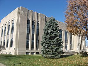
Shelby County Courthouse in Shelbyville
|
|

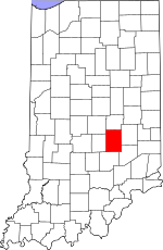
Location within the U.S. state of Indiana
|
|
 Indiana's location within the U.S. |
|
| Country | |
| State | |
| Founded | December 31, 1821 (authorized) 1822 (organized) |
| Named for | Isaac Shelby |
| Seat | Shelbyville |
| Largest city | Shelbyville |
| Area | |
| • Total | 412.76 sq mi (1,069.0 km2) |
| • Land | 411.15 sq mi (1,064.9 km2) |
| • Water | 1.61 sq mi (4.2 km2) 0.39%% |
| Population
(2020)
|
|
| • Total | 45,055 |
| • Estimate
(2023)
|
45,231 |
| • Density | 109.1554/sq mi (42.1452/km2) |
| Time zone | UTC−5 (Eastern) |
| • Summer (DST) | UTC−4 (EDT) |
| Congressional district | 6th |
| Indiana county number 48 | |
Shelby County is a county located in the state of Indiana. In 2020, about 45,055 people lived here. The main city and county seat is Shelbyville. It's the only official city in the county.
Contents
History of Shelby County
After the American Revolutionary War, the United States gained control of the land that is now Indiana. In 1787, this area became part of the Northwest Territory. Later, in 1800, it was named the Indiana Territory.
William Henry Harrison became the governor. The capital was set up in Vincennes. Over time, the territory changed shape. By December 1816, Indiana officially became a state.
Native American Lands
Before European settlers arrived, Native American tribes lived in these areas. They did not want to lose their lands. However, the U.S. government made agreements with some leaders. These agreements, called treaties, gave large parts of Native American land to the United States.
Important treaties in 1809 (Treaty of Fort Wayne) and 1818 (Treaty of St. Mary's) helped the U.S. gain control. The land that would become Shelby County was part of the 1818 treaty.
How Shelby County Was Formed
On December 31, 1821, the Indiana State Legislature decided to create four new counties. Shelby County was one of them. The county officially started on July 1, 1822. One of the first tasks was choosing a place for the county seat.
Who Was Shelby County Named After?
Shelby County was named after General Isaac Shelby. He was a hero in the American Revolutionary War. General Shelby led American forces to victory at the Battle of Kings Mountain.
After the war, he became the first Governor of Kentucky. He also played a key role in the War of 1812. He led Kentucky's army into Canada and won an important battle called the Battle of the Thames in 1813.
Geography of Shelby County
Shelby County has gentle, rolling hills. Most of the land is used for farming or city development. Several creeks and rivers flow through the county. Sugar Creek flows through the western part. The Big Blue River drains the central and southwest areas. The Flatrock River flows through the lower part of the county.
The land generally slopes towards the southwest. The highest points are about 930 feet above sea level. These are found along the northern border with Hancock County. In total, Shelby County covers about 412.76 square miles. Most of this (about 411.15 square miles) is land, and a small part (about 1.61 square miles) is water.
Cities and Towns
- Edinburgh (part)
- Fairland
- Morristown
- St. Paul (part)
- Shelbyville (city/county seat)
Small Communities
- Beech Brook
- Bengal
- Blue Ridge
- Boggstown
- Brookfield
- Candleglo Village
- Clover Village
- Fenns
- Flat Rock
- Fountaintown
- Freeport
- Geneva
- Green Meadows
- Gwynneville
- Knighthood Grove
- Knighthood Village
- Lewis Creek
- London
- London Heights
- Marietta
- Marion
- Meiks
- Meltzer
- Middletown
- Morven
- Mount Auburn
- Norristown
- Pleasant View
- Pleasure Valley
- Prescott
- Rays Crossing
- Rolling Ridge
- Sleepy Hollow
- Smithland
- Sugar Creek
- Waldron (census-designated place)
- Walkerville
- Wilson Corner
Townships in Shelby County
- Addison
- Brandywine
- Hanover
- Hendricks
- Jackson
- Liberty
- Marion
- Moral
- Noble
- Shelby
- Sugar Creek
- Union
- Van Buren
- Washington
Neighboring Counties
- Hancock County - north
- Rush County - east
- Decatur County - southeast
- Bartholomew County - south
- Johnson County - west
- Marion County - northwest
Main Roads
Climate and Weather
| Weather chart for Shelbyville, Indiana | |||||||||||||||||||||||||||||||||||||||||||||||
|---|---|---|---|---|---|---|---|---|---|---|---|---|---|---|---|---|---|---|---|---|---|---|---|---|---|---|---|---|---|---|---|---|---|---|---|---|---|---|---|---|---|---|---|---|---|---|---|
| J | F | M | A | M | J | J | A | S | O | N | D | ||||||||||||||||||||||||||||||||||||
|
2.4
35
18
|
2.4
40
22
|
3.4
51
31
|
3.9
63
41
|
4.5
73
52
|
3.9
82
61
|
4
86
65
|
3.5
84
63
|
2.7
78
55
|
2.8
66
43
|
3.6
52
35
|
2.8
40
24
|
||||||||||||||||||||||||||||||||||||
| temperatures in °F precipitation totals in inches source: The Weather Channel |
|||||||||||||||||||||||||||||||||||||||||||||||
|
Metric conversion
|
|||||||||||||||||||||||||||||||||||||||||||||||
In Shelbyville, the average temperature in January is about 18°F. In July, it's around 86°F. The coldest temperature ever recorded was -25°F in January 1994. The hottest was 105°F in July 1954.
Rainfall changes throughout the year. January usually gets about 2.38 inches of rain. May is the wettest month, with about 4.47 inches.
Population Information
| Historical population | |||
|---|---|---|---|
| Census | Pop. | %± | |
| 1830 | 6,295 | — | |
| 1840 | 12,005 | 90.7% | |
| 1850 | 15,502 | 29.1% | |
| 1860 | 19,569 | 26.2% | |
| 1870 | 21,892 | 11.9% | |
| 1880 | 25,257 | 15.4% | |
| 1890 | 25,454 | 0.8% | |
| 1900 | 26,491 | 4.1% | |
| 1910 | 26,802 | 1.2% | |
| 1920 | 25,982 | −3.1% | |
| 1930 | 26,552 | 2.2% | |
| 1940 | 25,953 | −2.3% | |
| 1950 | 28,026 | 8.0% | |
| 1960 | 34,093 | 21.6% | |
| 1970 | 37,797 | 10.9% | |
| 1980 | 39,887 | 5.5% | |
| 1990 | 40,307 | 1.1% | |
| 2000 | 43,445 | 7.8% | |
| 2010 | 44,436 | 2.3% | |
| 2020 | 45,055 | 1.4% | |
| 2023 (est.) | 45,231 | 1.8% | |
| US Decennial Census 1790-1960 1900-1990 1990-2000 2010 |
|||
In 2010, Shelby County had 44,436 people. Most residents (95.4%) were white. Other groups included 1.0% Black or African American and 0.5% Asian. About 3.7% of the population was of Hispanic or Latino origin.
The average age in the county was about 39.9 years old.
Education
Here are the school districts in Shelby County:
- Decatur County Community Schools
- Northwestern Consolidated School Corporation
- Shelby Eastern Schools
- Shelbyville Central Schools
- Southwestern Shelby County Consolidated Schools
Notable People from Shelby County
- Isaac Colton Ash – A member of the Los Angeles City Council from 1925 to 1927.
- George W. Clarke – Served as the governor of Iowa from 1913 to 1917.
- Edith Jones Woodward – An astronomer born in Waldron in 1914.
- Kid Quill – A hip hop and rap artist.
See also
 In Spanish: Condado de Shelby (Indiana) para niños
 | Selma Burke |
 | Pauline Powell Burns |
 | Frederick J. Brown |
 | Robert Blackburn |

