Rush County, Indiana facts for kids
Quick facts for kids
Rush County
|
|
|---|---|

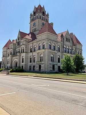
The Rush County Courthouse in Rushville
|
|

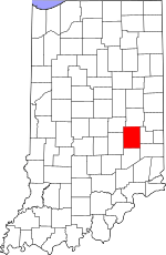
Location within the U.S. state of Indiana
|
|
 Indiana's location within the U.S. |
|
| Country | |
| State | |
| Founded | 1822 |
| Named for | Benjamin Rush |
| Seat | Rushville |
| Largest city | Rushville |
| Area | |
| • Total | 408.46 sq mi (1,057.9 km2) |
| • Land | 408.12 sq mi (1,057.0 km2) |
| • Water | 0.34 sq mi (0.9 km2) 0.08%% |
| Population
(2020)
|
|
| • Total | 16,752 |
| • Density | 41.0126/sq mi (15.8350/km2) |
| Time zone | UTC−5 (Eastern) |
| • Summer (DST) | UTC−4 (EDT) |
| Congressional district | 6th |
| Indiana county number 70 | |

Rush County is a place in the state of Indiana, USA. A county is like a smaller area within a state, with its own local government. In 2020, about 16,752 people lived here. The main town and county seat is Rushville. It's the only city in Rush County.
Contents
History of Rush County
When Indiana became a state on December 20, 1816, no one lived in the area that would become Rush County. But people started moving there quickly! By 1821, the new settlements wanted to form their own county.
So, on December 31, 1821, the state government made a law to create Rush County. It officially started on April 1, 1822. The first leaders began setting up the county's government on June 3, 1822. At first, there were six smaller areas called townships. Over the years, as more people moved in, the number of townships doubled to twelve.
The county was named after Dr. Benjamin Rush. He was an important person who signed the Declaration of Independence in 1776. In the summer of 1822, the town of Rushville was planned and built. It became the county seat.
Geography of Rush County
In the 1820s, Rush County had many trees, especially walnut and sugar maples. By 1879, Rush County was the biggest producer of maple syrup in Indiana! However, most of the trees were cut down for farming and building. Now, the land is mostly used for farms or towns.
Several rivers flow through the county. The Big Blue River flows through the northern part. The Little Blue River goes through the middle. The Flatrock River flows through the lower central part. The highest point in the county is about 1,135 feet (346 meters) above sea level. It's located near the eastern edge of the county, southwest of Glenwood.
In 2010, the county covered about 408.46 square miles. Almost all of this (99.92%) is land, and a very small part (0.08%) is water.
Counties Nearby
- Henry County - to the north
- Fayette County - to the east
- Franklin County - to the southeast
- Decatur County - to the south
- Shelby County - to the west
- Hancock County - to the northwest
Cities and Towns
Census-Designated Places
These are areas that are like towns but are not officially incorporated.
Unincorporated Towns
These are smaller communities that don't have their own local government.
Townships
Rush County is divided into 12 townships, which are smaller local government areas.
- Anderson
- Center
- Jackson
- Noble
- Orange
- Posey
- Richland
- Ripley
- Rushville
- Union
- Walker
- Washington
Main Roads
These are the major highways that go through Rush County.
Climate and Weather
| Weather chart for Rushville, Indiana | |||||||||||||||||||||||||||||||||||||||||||||||
|---|---|---|---|---|---|---|---|---|---|---|---|---|---|---|---|---|---|---|---|---|---|---|---|---|---|---|---|---|---|---|---|---|---|---|---|---|---|---|---|---|---|---|---|---|---|---|---|
| J | F | M | A | M | J | J | A | S | O | N | D | ||||||||||||||||||||||||||||||||||||
|
2.6
34
17
|
2.6
39
21
|
3.2
50
30
|
4.2
62
39
|
5.1
73
50
|
4.3
81
60
|
4.4
84
63
|
3.6
83
61
|
2.9
77
53
|
2.9
65
42
|
3.6
51
33
|
3.1
39
24
|
||||||||||||||||||||||||||||||||||||
| temperatures in °F precipitation totals in inches source: The Weather Channel |
|||||||||||||||||||||||||||||||||||||||||||||||
|
Metric conversion
|
|||||||||||||||||||||||||||||||||||||||||||||||
The weather in Rushville changes throughout the year. In January, the average low temperature is about 17°F (minus 8°C). In July, the average high temperature is about 84°F (29°C).
The coldest temperature ever recorded was minus 28°F (minus 33°C) in January 1994. The hottest temperature ever was 108°F (42°C) in July 1901.
The amount of rain and snow (precipitation) also changes. February usually has the least, with about 2.55 inches (6.5 cm). May usually has the most, with about 5.06 inches (12.9 cm).
People of Rush County (Demographics)
| Historical population | |||
|---|---|---|---|
| Census | Pop. | %± | |
| 1830 | 9,707 | — | |
| 1840 | 16,456 | 69.5% | |
| 1850 | 16,445 | −0.1% | |
| 1860 | 16,193 | −1.5% | |
| 1870 | 17,626 | 8.8% | |
| 1880 | 19,238 | 9.1% | |
| 1890 | 19,034 | −1.1% | |
| 1900 | 20,148 | 5.9% | |
| 1910 | 19,349 | −4.0% | |
| 1920 | 19,241 | −0.6% | |
| 1930 | 19,412 | 0.9% | |
| 1940 | 18,927 | −2.5% | |
| 1950 | 19,799 | 4.6% | |
| 1960 | 20,393 | 3.0% | |
| 1970 | 20,352 | −0.2% | |
| 1980 | 19,604 | −3.7% | |
| 1990 | 18,129 | −7.5% | |
| 2000 | 18,261 | 0.7% | |
| 2010 | 17,392 | −4.8% | |
| 2020 | 16,752 | −3.7% | |
| 2023 (est.) | 16,847 | −3.1% | |
| US Decennial Census 1790-1960 1900-1990 1990-2000 2010 |
|||
2010 Census Information
In 2010, there were 17,392 people living in Rush County. There were 6,767 households (groups of people living together) and 4,803 families.
Most of the people living in the county were white (97.4%). About 0.8% were black or African American, and 0.3% were Asian. About 1.1% of the population was of Hispanic or Latino background.
The average age of people in Rush County was 40.6 years old. About 32.8% of households had children under 18 living with them. Most households (54.9%) were married couples living together.
See also
 In Spanish: Condado de Rush (Indiana) para niños
 | Laphonza Butler |
 | Daisy Bates |
 | Elizabeth Piper Ensley |

