Franklin County, Indiana facts for kids
Quick facts for kids
Franklin County
|
|
|---|---|

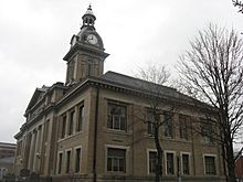
Franklin County Courthouse in Brookville Historic District
|
|

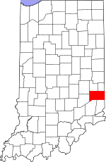
Location within the U.S. state of Indiana
|
|
 Indiana's location within the U.S. |
|
| Country | |
| State | |
| Founded | February 1, 1811 (authorized) |
| Named for | Benjamin Franklin |
| Seat | Brookville |
| Largest town | Brookville (entirely within county) Batesville (partial) |
| Area | |
| • Total | 391.05 sq mi (1,012.8 km2) |
| • Land | 384.43 sq mi (995.7 km2) |
| • Water | 6.62 sq mi (17.1 km2) 1.69%% |
| Population
(2020)
|
|
| • Total | 22,785 |
| • Estimate
(2023)
|
23,096 |
| • Density | 59.1/sq mi (22.8/km2) |
| Time zone | UTC−5 (Eastern) |
| • Summer (DST) | UTC−4 (EDT) |
| Congressional district | 6th |
| Indiana county number 24 | |
Franklin County is a place in eastern Indiana, right on the border with Ohio. In 2020, about 22,785 people lived here. The main town and county seat is Brookville.
Franklin County is also part of the larger Cincinnati, Ohio, Kentucky, and Indiana area. The only city that is partly in Franklin County is Batesville, but most of it is in a nearby county called Ripley County.
Contents
Exploring Franklin County's Geography
Franklin County is located on the eastern side of Indiana. Its eastern border touches the state of Ohio. The area has gentle, rolling hills. These hills were once completely covered in forests. Now, some parts have been cleared for farming. The small valleys and streams still have a lot of trees and bushes.
The county covers a total area of about 391 square miles. Most of this, about 384 square miles, is land. The rest, about 6.6 square miles, is water.
A large lake called Brookville Lake stretches into the northern part of the county. This lake was created by a dam on the East Branch of the Whitewater River. This river is a branch of the Great Miami River.
Another part of the Whitewater River, called the West Branch, flows into the county from Fayette County. It meets the East Branch in Brookville. Together, they form the main Whitewater River, which then flows southeast into Dearborn County.
In the southern and southwestern parts of Franklin County, smaller streams like Salt Creek, Pipe Creek, and Blue Creek flow northeast into the Whitewater River. The highest point in the county is a small hill near Andersonville. It is about 1,070 feet above sea level.
Neighboring Counties of Franklin County
Franklin County shares its borders with several other counties:
- Fayette County - to the north
- Union County - to the northeast
- Butler County, Ohio - to the east
- Hamilton County, Ohio - to the southeast
- Dearborn County - to the south
- Ripley County - to the southwest
- Decatur County - to the west
- Rush County - to the northwest
Main Roads in Franklin County
These are the major roads that help people travel through Franklin County:
 Interstate 74
 U.S. Route 52
 Indiana State Road 1
 Indiana State Road 46
 Indiana State Road 101
 Indiana State Road 121
 Indiana State Road 229
 Indiana State Road 244
 Indiana State Road 252
Natural Areas and Lakes
Franklin County has a special protected area for nature:
- Mounds State Recreation Area
It also has a large lake:
- Brookville Lake (part of it is in the county)
Communities in Franklin County
Franklin County has different types of communities where people live.
Cities in Franklin County
- Batesville (only part of this city is in Franklin County)
Towns in Franklin County
- Brookville (this is the county seat, where the main government offices are)
- Cedar Grove
- Laurel
- Mount Carmel
- Oldenburg
- West Harrison (only part of this town is in Franklin County)
col end}}
Special Designated Places
These are areas that are recognized for census purposes:
- Lake Santee (part of it)
- Metamora
- New Trenton
Smaller Unincorporated Communities
These are smaller settlements that are not officially organized as cities or towns:
- Andersonville
- Bath
- Blooming Grove
- Buena Vista
- Drewersburg
- Enochsburg
- Fairfield (no longer exists)
- Hamburg
- Highland Center
- Huntersville
- Klemmes Corner
- Lake View
- Midway
- Millville
- Mixersville
- Mound Haven
- Mount Auburn
- New Fairfield
- Oak Forest
- Old Bath
- Palestine
- Peoria
- Peppertown
- Raymond
- Rockdale
- Saint Marys
- Saint Peter
- Scipio (part of it)
- Sharptown
- South Gate
- Stavetown
- Whitcomb
- Yellow Bank
- Youngs Corner
Townships in Franklin County
Townships are smaller local government areas within the county:
- Bath Township
- Blooming Grove Township
- Brookville Township
- Butler Township
- Fairfield Township
- Highland Township
- Laurel Township
- Metamora Township
- Posey Township
- Ray Township
- Salt Creek Township
- Springfield Township
- Whitewater Township
History of Franklin County
The land that would become Indiana was first organized by the U.S. Congress in 1787. This was known as the Northwest Ordinance. In 1790, the area was divided into two counties. Knox County covered much of what is now Indiana.
In 1810, a part of Knox County was separated to create Wayne County. Soon after, a southern part was taken to form Franklin County. This happened on February 1, 1811. The county was named after the famous American statesman, Benjamin Franklin.
Some of the first European settlers in Franklin County were a group called Primitive Baptists. They came from Virginia in 1797, after the American Revolutionary War. They started the first church in the Whitewater Valley area. It was called the Little Cedar Grove Baptist Church. They built a small log chapel southeast of Brookville in 1805.
Another important historical church is the Big Cedar Baptist Church and Burying Ground. The original church was started in 1817. The brick building that stands today was built in 1838. This church, like many early Baptist groups, was originally very traditional.
In the 1830s, new ideas came to the county. These included things like Sunday schools, missionary groups, and using organs in church. The traditional group, called "Hardshells," did not like organs. They thought it was wrong to use musical instruments in worship.
Because of these differences, the Big Cedar church group split into two. However, they found a friendly way to share the same building. The traditional group used the church on the first and third Sundays of each month. The more modern group used it on the second and fourth Sundays. Today, the building is cared for by the Big Cedar Cemetery Association.
Three governors of Indiana were known as the "Brookville Triumvirate." They were James B. Ray, Noah Noble, and David Wallace. All three had lived in Brookville and were elected as Indiana governors one after another.
Another important person from Franklin County was James B. Goudie Jr. (1769–1836). He was the Speaker of the Indiana House of Representatives.
Climate and Weather in Franklin County
| Weather chart for Brookville, Indiana | |||||||||||||||||||||||||||||||||||||||||||||||
|---|---|---|---|---|---|---|---|---|---|---|---|---|---|---|---|---|---|---|---|---|---|---|---|---|---|---|---|---|---|---|---|---|---|---|---|---|---|---|---|---|---|---|---|---|---|---|---|
| J | F | M | A | M | J | J | A | S | O | N | D | ||||||||||||||||||||||||||||||||||||
|
3
36
17
|
2.7
42
20
|
3.8
53
29
|
4
64
38
|
4.9
74
48
|
4.1
83
58
|
4.3
87
62
|
3.9
85
60
|
2.7
79
52
|
3
67
40
|
3.7
53
32
|
3.3
41
23
|
||||||||||||||||||||||||||||||||||||
| temperatures in °F precipitation totals in inches source: The Weather Channel |
|||||||||||||||||||||||||||||||||||||||||||||||
|
Metric conversion
|
|||||||||||||||||||||||||||||||||||||||||||||||
The weather in Brookville, Franklin County, changes throughout the year. In January, the average low temperature is about 17 degrees Fahrenheit. In July, the average high temperature is about 87 degrees Fahrenheit.
The coldest temperature ever recorded was -31 degrees Fahrenheit in January 1994. The hottest temperature ever recorded was 104 degrees Fahrenheit in September 1951.
The amount of rain and snow also varies. On average, September is the driest month with about 2.68 inches of precipitation. May is the wettest month, with about 4.90 inches of precipitation.
Population and People of Franklin County
| Historical population | |||
|---|---|---|---|
| Census | Pop. | %± | |
| 1820 | 10,763 | — | |
| 1830 | 10,190 | −5.3% | |
| 1840 | 13,349 | 31.0% | |
| 1850 | 17,968 | 34.6% | |
| 1860 | 19,549 | 8.8% | |
| 1870 | 20,223 | 3.4% | |
| 1880 | 20,092 | −0.6% | |
| 1890 | 18,366 | −8.6% | |
| 1900 | 16,388 | −10.8% | |
| 1910 | 15,335 | −6.4% | |
| 1920 | 14,806 | −3.4% | |
| 1930 | 14,498 | −2.1% | |
| 1940 | 14,412 | −0.6% | |
| 1950 | 16,034 | 11.3% | |
| 1960 | 17,015 | 6.1% | |
| 1970 | 16,943 | −0.4% | |
| 1980 | 19,612 | 15.8% | |
| 1990 | 19,580 | −0.2% | |
| 2000 | 22,151 | 13.1% | |
| 2010 | 23,087 | 4.2% | |
| 2020 | 22,785 | −1.3% | |
| 2023 (est.) | 23,096 | 0.0% | |
| US Decennial Census 1790–1960 1900–1990 1990–2000 2010–2013 |
|||
The population of Franklin County has changed over many years. In 1820, there were about 10,763 people. By 2020, the population had grown to 22,785 people. In 2023, it was estimated to be around 23,096 people.
What the 2010 Census Showed
In 2010, there were 23,087 people living in Franklin County. There were about 8,579 households, which are groups of people living together. Most people in the county were white (98.3%). A small number were from other racial backgrounds. About 0.9% of the population was of Hispanic or Latino origin.
Many people in Franklin County have German roots (40.3%). Other common backgrounds include American (14.7%), Irish (13.1%), and English (9.5%).
About 35.9% of households had children under 18 living with them. Most households (61.6%) were married couples. The average household had 2.67 people. The average age of people in the county was 40 years old.
Education in Franklin County
Students in Franklin County attend schools in different school districts:
- Batesville Community School Corporation
- Franklin County Community School Corporation
- Union County-College Corner Joint School District
See also
 In Spanish: Condado de Franklin (Indiana) para niños
 | William M. Jackson |
 | Juan E. Gilbert |
 | Neil deGrasse Tyson |


