Laurel, Indiana facts for kids
Quick facts for kids
Laurel, Indiana
|
|
|---|---|
 |
|

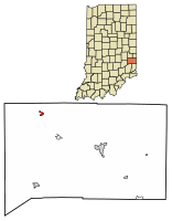
Location of Laurel in Franklin County, Indiana.
|
|
| Country | United States |
| State | Indiana |
| County | Franklin |
| Township | Laurel |
| Area | |
| • Total | 0.24 sq mi (0.62 km2) |
| • Land | 0.24 sq mi (0.62 km2) |
| • Water | 0.00 sq mi (0.00 km2) |
| Elevation | 728 ft (222 m) |
| Population
(2020)
|
|
| • Total | 406 |
| • Density | 1,705.88/sq mi (658.58/km2) |
| Time zone | UTC-5 (Eastern (EST)) |
| • Summer (DST) | UTC-4 (EDT) |
| ZIP code |
47024
|
| Area code(s) | 765 |
| FIPS code | 18-42372 |
| GNIS feature ID | 2396710 |
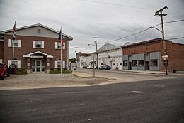
Laurel is a small town located in Franklin County, Indiana, in the United States. It is part of Laurel Township. In 2020, about 406 people lived there.
Contents
History of Laurel, Indiana
When Was Laurel Established?
Laurel was officially planned in 1836 by a man named James Conwell. He was from Maryland. Conwell first wanted to call his new settlement New Baltimore. However, he later decided to name it Laurel, just like the city of Laurel, Maryland.
The Last Passenger Pigeon
A very sad event happened near Laurel in 1902. The last wild passenger pigeon was shot there. These birds were once the most common birds in North America. Sadly, they are now extinct.
Laurel's Post Office History
The town's post office opened in 1837. This meant people in Laurel could send and receive mail easily.
Geography of Laurel
What is the Size of Laurel?
According to the 2010 census, Laurel covers a total area of about 0.24 square miles (0.62 square kilometers). All of this area is land.
Population and People in Laurel
How Many People Live in Laurel?
The population of Laurel has changed over the years. Here's how many people lived there at different times:
| Historical population | |||
|---|---|---|---|
| Census | Pop. | %± | |
| 1860 | 670 | — | |
| 1870 | 741 | 10.6% | |
| 1880 | 670 | −9.6% | |
| 1900 | 600 | — | |
| 1910 | 503 | −16.2% | |
| 1920 | 515 | 2.4% | |
| 1930 | 516 | 0.2% | |
| 1940 | 533 | 3.3% | |
| 1950 | 680 | 27.6% | |
| 1960 | 848 | 24.7% | |
| 1970 | 753 | −11.2% | |
| 1980 | 819 | 8.8% | |
| 1990 | 544 | −33.6% | |
| 2000 | 579 | 6.4% | |
| 2010 | 512 | −11.6% | |
| 2020 | 406 | −20.7% | |
| U.S. Decennial Census | |||
Laurel's Population in 2010
In 2010, there were 512 people living in Laurel. These people lived in 196 households, and 134 of these were families. The town had about 2,133 people per square mile.
Most of the people in Laurel were White (98.4%). A small number were African American (0.2%), Native American (0.6%), or from other backgrounds. About 2.5% of the population identified as Hispanic or Latino.
Households and Families
Out of the 196 households, 38.3% had children under 18 living with them. About 39.3% were married couples. Some households were led by a single parent. About 23% of all households were individuals living alone.
The average household had 2.61 people. The average family had 3.08 people.
Age of Residents
The average age of people in Laurel in 2010 was 34.8 years old.
- 27% of residents were under 18.
- 10.4% were between 18 and 24.
- 27.9% were between 25 and 44.
- 21% were between 45 and 64.
- 13.7% were 65 or older.
The town had slightly more males (51.0%) than females (49.0%).
Education in Laurel
Public Library Services
Laurel has a public library. It is a branch of the Franklin County Public Library District. This means residents can borrow books, use computers, and access other learning resources.
Notable People from Laurel
- James Emmert: He was an important person in Indiana. He served as the Indiana Attorney General and was also a Justice on the Indiana Supreme Court.
See also
 In Spanish: Laurel (Indiana) para niños
 | Sharif Bey |
 | Hale Woodruff |
 | Richmond Barthé |
 | Purvis Young |

