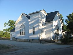
Charlottesville, Indiana facts for kids
Quick facts for kids
Charlottesville, Indiana
|
|
|---|---|

Charlottesville Friends Church
|
|
| Country | United States |
| State | Indiana |
| Counties | Hancock, Rush |
| Townships | Jackson (H), Ripley (R) |
| Elevation | 948 ft (289 m) |
| Population
(2012)
|
|
| • Total | 631 |
| Time zone | UTC-5 (Eastern (EST)) |
| • Summer (DST) | UTC-4 (EDT) |
| ZIP code |
46117
|
| Area code(s) | 765 |
| FIPS code | 18-12196 |
| GNIS feature ID | 2830398 |
Charlottesville is a small community in Indiana, USA. It's not officially a city or town. It's located across two counties: Hancock County and Rush County. Part of Charlottesville is in Jackson Township, and another part is in Ripley Township.
A Look Back in Time
Charlottesville started in 1830. This means its streets and lots were planned out. It might have been named after Charlottesville, Virginia. For a while, starting in 1867, it was an official town. The community has had a post office since 1831.
Getting Around
Charlottesville is easy to reach. Two important roads pass through or near it.
Main Roads
 U.S. Route 40
 I-70
I-70
Schools in the Area
The Eastern Hancock Community School Corporation serves Charlottesville. It also helps students from nearby towns. These towns include Wilkinson, Shirley, and Warrington. The school system has three main schools:
- An elementary school for grades K-5.
- A middle school for grades 6-8.
- A high school for grades 9-12.
 | Stephanie Wilson |
 | Charles Bolden |
 | Ronald McNair |
 | Frederick D. Gregory |


