Monrovia, Indiana facts for kids
Quick facts for kids
Monrovia, Indiana
|
|
|---|---|

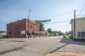
Downtown Monrovia
|
|

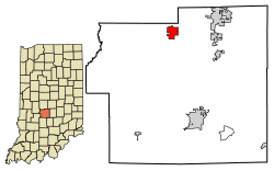
Location in Morgan County, Indiana
|
|
| Country | United States |
| State | Indiana |
| County | Morgan |
| Township | Monroe |
| Area | |
| • Total | 1.80 sq mi (4.65 km2) |
| • Land | 1.80 sq mi (4.65 km2) |
| • Water | 0.00 sq mi (0.00 km2) |
| Elevation | 794 ft (242 m) |
| Population
(2020)
|
|
| • Total | 1,643 |
| • Density | 915.32/sq mi (353.37/km2) |
| Time zone | UTC-5 (Eastern (EST)) |
| • Summer (DST) | UTC-4 (EDT) |
| ZIP code |
46157
|
| Area code(s) | 317, 463 |
| FIPS code | 18-50580 |
| GNIS feature ID | 2396774 |
Monrovia is a friendly town located in Indiana, a state in the United States. It's part of Morgan County, specifically in Monroe Township. In 2020, about 1,643 people lived here, which is more than the 1,063 people who lived here in 2010!
Contents
Discovering Monrovia's Past
Monrovia was started in 1834. It was named after James Monroe, who was a famous person in American history. A post office has been open in Monrovia since it began in 1834.
The Lake Ditch Bridge is an important landmark. It was added to the National Register of Historic Places in 2001. This means it's a special place recognized for its history.
In 2018, a documentary film called Monrovia, Indiana was made about the town. It was directed by Frederick Wiseman.
Exploring Monrovia's Location
Monrovia is in the northern part of Morgan County. You can find it at these coordinates: 39.579389 degrees North and -86.480402 degrees West.
Two main roads go through the town. Indiana State Road 42 is like Main Street, and State Road 39 is Chestnut Street. State Road 42 goes northeast to Mooresville (about 6 miles away) and west to Little Point (about 9 miles away). State Road 39 goes north to Belleville (about 7 miles away) and south to Martinsville (about 12 miles away). Martinsville is the main city of Morgan County.
A big highway called Interstate 70 is about 2 miles north of Monrovia. You can get to it from Exit 59 at State Road 39. If you want to visit Indianapolis, it's about 24 miles northeast of Monrovia.
Understanding Monrovia's Land and Water
Monrovia covers an area of about 1.80 square miles (4.65 square kilometers). Almost all of this area is land, with very little water. The town is on a small hill. Water from the east side flows towards Sycamore Creek and McCracken Creek. These creeks eventually flow into the White River. Water from the west side flows towards Mill Creek, which is a part of the Eel River. The Eel River also flows into the White River.
Monrovia's Population Facts
| Historical population | |||
|---|---|---|---|
| Census | Pop. | %± | |
| 2000 | 628 | — | |
| 2010 | 1,063 | 69.3% | |
| 2020 | 1,643 | 54.6% | |
| U.S. Decennial Census | |||
Monrovia has grown quite a bit over the years! In 2000, there were 628 people living here. By 2010, the population had increased to 1,063 people. The latest count in 2020 showed that 1,643 people call Monrovia home. This means more and more families are choosing to live in this town.
Learning in Monrovia
The Monroe-Gregg School District helps students in Monroe and Gregg townships get a great education. They have three schools:
- Monrovia Elementary School: This is a newer school for students in kindergarten through 5th grade.
- Monrovia Middle School: Students in 6th, 7th, and 8th grades go here.
- Monrovia Junior-Senior High School: This school is for older students, from 9th to 12th grade.
Monrovia also has a public library. It's a part of the Morgan County Public Library system, where you can find books, computers, and other resources.
Famous People from Monrovia
Some notable people have come from Monrovia:
- Gary Bettenhausen: A well-known IndyCar driver.
- John Van Lindley: An expert in growing fruit (a pomologist) and an early nurseryman.
- Branch McCracken: A successful college basketball coach who won championships.
- John Standeford: A wide receiver who played in the NFL.
See also
 In Spanish: Monrovia (Indiana) para niños
 | Janet Taylor Pickett |
 | Synthia Saint James |
 | Howardena Pindell |
 | Faith Ringgold |

