Mooresville, Indiana facts for kids
Quick facts for kids
Mooresville, Indiana
|
|||
|---|---|---|---|
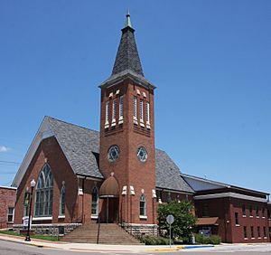
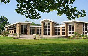
Mooresville Government Center, formerly a Methodist church
|
|||
|
|||
| Nickname(s):
"Home of the State Flag"
|
|||
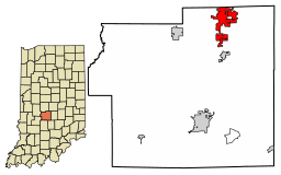
Location in Morgan County, Indiana
|
|||
| Country | United States | ||
| State | Indiana | ||
| County | Morgan | ||
| Township | Brown | ||
| Founded by | Samuel Moore | ||
| Area | |||
| • Total | 6.76 sq mi (17.52 km2) | ||
| • Land | 6.71 sq mi (17.37 km2) | ||
| • Water | 0.06 sq mi (0.15 km2) | ||
| Elevation | 659 ft (201 m) | ||
| Population
(2020)
|
|||
| • Total | 9,411 | ||
| • Density | 1,403.37/sq mi (541.88/km2) | ||
| Time zone | UTC-5 (Eastern (EST)) | ||
| • Summer (DST) | UTC-4 (EDT) | ||
| ZIP code |
46158
|
||
| Area code(s) | 317, 463 | ||
| FIPS code | 18-50976 | ||
| GNIS feature ID | 2396780 | ||
Mooresville is a town located in Morgan County, Indiana, in the United States. It's famous because the current flag of Indiana was designed here. In 2020, about 9,411 people lived in Mooresville.
Contents
History of Mooresville
Mooresville was started in 1824 by Samuel Moore. He bought the land for $2 an acre, and the town was named after him. A post office has been open in Mooresville since 1826.
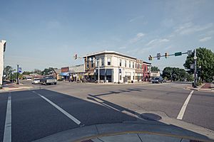
Some important buildings in Mooresville are listed on the National Register of Historic Places. These include the Mooresville Commercial Historic District, the Mooresville Friends Academy Building, and the Mooresville Gymnasium.
The Indiana State Flag
A local artist named Paul Hadley designed the current Indiana state flag. He was a watercolorist and created the flag in 1916. This was for a contest held by the Daughters of the American Revolution to celebrate Indiana's 100th birthday. Hadley's design became the official state banner in 1917. Later, in 1955, it was officially renamed the state flag.
The Mooresville Town Flag
The official Mooresville town flag was designed in 1974. This was to celebrate the town's 150th anniversary. It looks similar to the Indiana state flag because Mooresville is where the state flag was created.
The town flag has a yellow background. It features a circle of 19 blue stars, with the top star being the biggest. In the middle, there's a blue cross with the date "1824" and a small blue star. The name "Mooresville" is written below the cross with curved letters. The 19 stars show that Indiana was the 19th state to join the U.S. The large star represents Indiana's statehood. The cross in the center stands for Indiana's motto: "the crossroads of America." The date "1824" is when Mooresville was founded. The star on the cross shows Mooresville's location near Indianapolis.
Recent Events
On April 8, 2020, a strong wind event hit downtown Mooresville. A building on Indiana and Main streets partly collapsed, but luckily, no one was hurt. The old building was later taken down because it couldn't be fixed.
In November 2023, the Walmart store worked with Hasbro to release a special Monopoly board game. It was called "Mooresville-Opoly" and was sold for a short time only at the Camby Walmart store.
Geography of Mooresville
Mooresville is located in the northeastern part of Morgan County. Its northern border touches the Hendricks County line.
The town covers about 6.76 square miles (17.52 square kilometers). Most of this area is land, with a small part being water. The center of Mooresville is between White Lick Creek to the west and its East Fork to the east. White Lick Creek flows south and joins the White River near Martinsville.
Population Information
| Historical population | |||
|---|---|---|---|
| Census | Pop. | %± | |
| 1850 | 550 | — | |
| 1860 | 780 | 41.8% | |
| 1870 | 1,229 | 57.6% | |
| 1880 | 864 | −29.7% | |
| 1890 | 891 | 3.1% | |
| 1900 | 974 | 9.3% | |
| 1910 | 1,608 | 65.1% | |
| 1920 | 1,781 | 10.8% | |
| 1930 | 1,910 | 7.2% | |
| 1940 | 1,979 | 3.6% | |
| 1950 | 2,264 | 14.4% | |
| 1960 | 3,856 | 70.3% | |
| 1970 | 5,800 | 50.4% | |
| 1980 | 5,349 | −7.8% | |
| 1990 | 5,541 | 3.6% | |
| 2000 | 9,273 | 67.4% | |
| 2010 | 9,326 | 0.6% | |
| 2020 | 9,411 | 0.9% | |
| U.S. Decennial Census | |||
2010 Census Details
In 2010, there were 9,326 people living in Mooresville. There were 3,715 households, and 2,558 families. The town had about 1,483 people per square mile. Most of the people living in Mooresville were White (97.5%).
About 36% of households had children under 18. Nearly half (49%) were married couples. The average age in Mooresville was about 38.6 years old.
Arts and Culture
Every year in early August, Mooresville hosts the "Old Settlers Fair." This event includes a parade through downtown and carnival rides at Pioneer Park. It usually lasts for three or four days. The first fair was held on August 9, 1870, and was originally called the Old Settlers Reunion and Picnic. It took place at Old Town Park until 1995, when it moved to Pioneer Park.
The town also has a place to borrow books, called the Mooresville Public Library.
Education in Mooresville
Schools in Mooresville are part of the Mooresville Consolidated School Corporation. These include:
- Newby Memorial Elementary
- Neil A. Armstrong Elementary (named after the famous astronaut)
- Northwood Elementary
- North Madison Elementary
- Waverly Elementary
- Paul Hadley Middle School (named after the Indiana state flag designer)
- Mooresville High School
Private School
- Mooresville Christian Academy, which started in 1975.
Mooresville Friends Academy Building
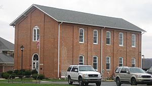
The Mooresville school system began with the Friends Academy, built in 1861. This Academy Building was one of the first high schools in Indiana. It was a boarding school where students rented rooms from local families.
Today, the old Academy Building is on the Newby Memorial Elementary School campus. It has been fixed up and is listed on the National Register of Historic Places. Now, it serves as a local history museum and offices for the Community Foundation of Morgan County, Inc.
Also on the Newby campus is the "old Newby gym," sometimes called the "Newby Dome." This gym was built in the early 1900s with help from Mooresville residents. Each person contributed $100 to help build it. The campus also has the Mooresville Veterans Memorial. This memorial honors soldiers from Mooresville who died in World War I and later wars. It also honors Sammy Lee Davis, who received the Medal of Honor for his bravery in Vietnam. Davis is known as "The Real Forrest Gump" because his story from Vietnam is similar to parts of the movie Forrest Gump, and footage from his Medal of Honor ceremony was used in the film.
Transportation
Mooresville is served by Indiana State Road 67. Other state roads, Indiana State Road 42 and Indiana State Road 144, end at SR 67 southeast of the town center.
Notable People from Mooresville
- William G. Bray: A Republican who served in the U.S. House of Representatives for many years.
- Herbert Carter: A biochemist.
- John Dillinger: A famous bank robber who sometimes used Mooresville as a place to hide.
- Paul Hadley: The person who designed the Indiana state flag.
- Julia D. Nelson: The first woman elected to the Indiana House of Representatives in 1921.
- Amos Rusie: A member of the Baseball Hall of Fame.
- Ruth Hinshaw Spray: A peace activist.
- Nan Whaley: A former mayor of Dayton, Ohio.
See also
 In Spanish: Mooresville (Indiana) para niños
 | Aurelia Browder |
 | Nannie Helen Burroughs |
 | Michelle Alexander |


