Staunton, Indiana facts for kids
Quick facts for kids
Staunton, Indiana
|
|
|---|---|

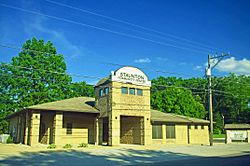
Staunton Community Center
|
|

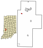
Location of Staunton in Clay County, Indiana.
|
|
| Country | United States |
| State | Indiana |
| County | Clay |
| Township | Posey |
| Area | |
| • Total | 0.33 sq mi (0.85 km2) |
| • Land | 0.33 sq mi (0.85 km2) |
| • Water | 0.00 sq mi (0.00 km2) |
| Elevation | 646 ft (197 m) |
| Population
(2020)
|
|
| • Total | 472 |
| • Density | 1,443.43/sq mi (557.63/km2) |
| Time zone | UTC-5 (Eastern (EST)) |
| • Summer (DST) | UTC-4 (EDT) |
| ZIP code |
47881
|
| Area code(s) | 812 |
| FIPS code | 18-72782 |
| GNIS feature ID | 0449846 |
Staunton is a small town in Clay County, Indiana, United States. It is located in Posey Township. In 2020, about 472 people lived there. Staunton is part of the larger Terre Haute metropolitan area.
Contents
History of Staunton
Staunton started as a town in 1851. This was when a railroad line was built through the area. The town was named after another place called Staunton, Virginia.
Early 1900s Politics
In the 1910s, something interesting happened. All the people elected to lead the town were from the Socialist Party of America. This was a political group that believed in everyone sharing resources. They thought people should work together for the good of the whole community.
Staunton in Pop Culture
Staunton, Indiana, is featured in a children's book. The book is called "Altus Brown and the Great Sulphur Creek Bike Jump." It tells the story of a fictional character named Altus Brown.
Author's Connection to Staunton
The author, E. Michael Brown, grew up in Staunton. He lived there in the 1970s and 1980s. He wrote the book to show how special small-town life can be. It also highlights the unique people who live in such towns.
Geography of Staunton
Staunton is located in the state of Indiana. Its exact location is 39°29′14″N 87°11′18″W / 39.48722°N 87.18833°W.
Size of the Town
According to the 2010 census, Staunton covers a total area of about 0.34 square miles (0.88 square kilometers). All of this area is land.
Population of Staunton
The population of Staunton has changed over the years. Here is a look at how many people have lived in the town since 1870:
| Historical population | |||
|---|---|---|---|
| Census | Pop. | %± | |
| 1870 | 589 | — | |
| 1880 | 581 | −1.4% | |
| 1890 | 549 | −5.5% | |
| 1900 | 693 | 26.2% | |
| 1910 | 746 | 7.6% | |
| 1920 | 642 | −13.9% | |
| 1930 | 482 | −24.9% | |
| 1940 | 387 | −19.7% | |
| 1950 | 487 | 25.8% | |
| 1960 | 490 | 0.6% | |
| 1970 | 582 | 18.8% | |
| 1980 | 607 | 4.3% | |
| 1990 | 592 | −2.5% | |
| 2000 | 550 | −7.1% | |
| 2010 | 534 | −2.9% | |
| 2020 | 472 | −11.6% | |
| U.S. Decennial Census | |||
2010 Population Details
In 2010, there were 534 people living in Staunton. These people lived in 199 households. A household is a group of people living together. Out of these, 146 were families.
People and Households
- About 40% of households had children under 18 living there.
- Most households (about 59%) were married couples living together.
- Some households (about 10%) had a female head with no husband.
- A small number (about 3%) had a male head with no wife.
- About 20% of households were single individuals.
- About 7% of households had someone aged 65 or older living alone.
- The average household had about 2.68 people.
- The average family had about 3.10 people.
Age and Gender
The median age in Staunton in 2010 was 36.6 years. This means half the people were younger and half were older than 36.6.
- About 29% of residents were under 18 years old.
- About 5% were between 18 and 24 years old.
- About 28% were between 25 and 44 years old.
- About 25% were between 45 and 64 years old.
- About 11% were 65 years or older.
The town had a nearly equal number of males and females. About 50.2% were male and 49.8% were female.
See also
 In Spanish: Staunton (Indiana) para niños
 | Victor J. Glover |
 | Yvonne Cagle |
 | Jeanette Epps |
 | Bernard A. Harris Jr. |

