Howesville, Indiana facts for kids
Quick facts for kids
Howesville
|
|
|---|---|
| Country | United States |
| State | Indiana |
| County | Clay |
| Township | Lewis |
| Elevation | 548 ft (167 m) |
| ZIP code |
47438
|
| FIPS code | 18-35014 |
| GNIS feature ID | 436555 |
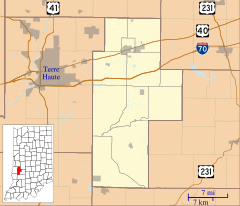
Howesville is a small community located in Clay County, Indiana, in the United States. It is known as an unincorporated community, which means it doesn't have its own separate local government like a city or town. Instead, it's part of a larger area called Lewis Township. Howesville is also included in the Terre Haute Metropolitan Statistical Area, which is a group of nearby cities and towns connected to the larger city of Terre Haute.
A Look Back in Time
Howesville was first planned and established in the year 1856. This is when the community officially began to take shape.
Just a couple of years later, in 1858, a post office was opened in Howesville. A post office was very important back then. It was the main way people could send and receive letters and packages. This post office served the community for many years. However, it eventually closed its doors in 1909.
Where is Howesville?
Howesville is located in the state of Indiana. You can find its exact spot on a map using special numbers called geographic coordinates. These coordinates are 39°10′37″N 87°08′49″W / 39.17694°N 87.14694°W. This means it's at 39 degrees, 10 minutes, 37 seconds North latitude and 87 degrees, 8 minutes, 49 seconds West longitude. These numbers help pinpoint its precise location on Earth.
 | Mary Eliza Mahoney |
 | Susie King Taylor |
 | Ida Gray |
 | Eliza Ann Grier |


