Hutsonville, Illinois facts for kids
Quick facts for kids
Hutsonville, Illinois
|
|
|---|---|

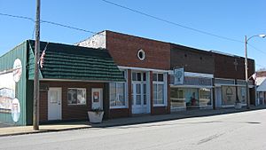
Downtown Hutsonville
|
|

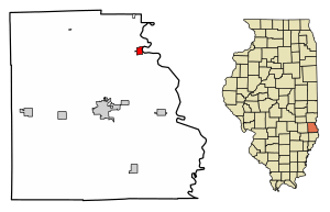
Location of Hutsonville in Crawford County, Illinois.
|
|

Location of Illinois in the United States
|
|
| Country | United States |
| State | Illinois |
| County | Crawford |
| Area | |
| • Total | 0.62 sq mi (1.61 km2) |
| • Land | 0.62 sq mi (1.61 km2) |
| • Water | 0.00 sq mi (0.00 km2) |
| Elevation | 449 ft (137 m) |
| Population
(2020)
|
|
| • Total | 478 |
| • Density | 768.49/sq mi (296.84/km2) |
| Time zone | UTC-6 (CST) |
| • Summer (DST) | UTC-5 (CDT) |
| ZIP Code(s) |
62433
|
| Area code(s) | 618 |
| FIPS code | 17–36841 |
| GNIS feature ID | 2398565 |
| Wikimedia Commons | Hutsonville, Illinois |
Hutsonville is a small village in Crawford County, Illinois, United States. It is located in the eastern part of Illinois. In 2020, about 478 people lived there.
Contents
Where is Hutsonville Located?
Hutsonville is in the northeastern part of Crawford County. It sits right next to the Wabash River. This river also forms the border with the state of Indiana.
Main Roads and Directions
The main east-west street in the village is Clover Street. If you go east on Clover Street, you cross the river into Indiana. There, it becomes Indiana State Road 154. This road leads about 15 miles (24 km) east to Sullivan, Indiana.
If you go west on Clover Street, you will reach Illinois Route 1 in about 1.5 miles (2.4 km). This route goes north about 20 miles (32 km) to Marshall. It also goes south about 26 miles (42 km) to Lawrenceville. Hutsonville's Main Street goes south about 8 miles (13 km) to Palestine.
Size of the Village
According to the 2010 census, Hutsonville covers a total area of about 0.62 square miles (1.61 square kilometers). All of this area is land.
Who Lives in Hutsonville?
This section shares information about the people who live in Hutsonville.
Population Over Time
The number of people living in Hutsonville has changed over many years. Here's a look at the population from 1880 to 2020:
| Historical population | |||
|---|---|---|---|
| Census | Pop. | %± | |
| 1880 | 418 | — | |
| 1890 | 582 | 39.2% | |
| 1900 | 743 | 27.7% | |
| 1910 | 722 | −2.8% | |
| 1920 | 665 | −7.9% | |
| 1930 | 604 | −9.2% | |
| 1940 | 714 | 18.2% | |
| 1950 | 647 | −9.4% | |
| 1960 | 583 | −9.9% | |
| 1970 | 544 | −6.7% | |
| 1980 | 705 | 29.6% | |
| 1990 | 622 | −11.8% | |
| 2000 | 568 | −8.7% | |
| 2010 | 554 | −2.5% | |
| 2020 | 478 | −13.7% | |
| U.S. Decennial Census | |||
Recent Population Details (2020)
In 2020, there were 478 people living in Hutsonville. There were 255 households and 136 families. The village had about 768 people per square mile (297 per square kilometer). There were 221 housing units, which are places where people live.
Most people in the village were White (94.14%). A small number were African American, Native American, or Asian. Some people were from other races or from two or more races. About 3.35% of the population was Hispanic or Latino.
Households and Families
Out of 255 households, about 20.8% had children under 18 living with them. About 47.06% were married couples. Almost half (46.67%) were not families. About 27.45% of households had only one person living there. About 9.41% had someone aged 65 or older living alone.
The average household had about 2.77 people. The average family had about 2.09 people.
Age Groups
The village's population included people of all ages. About 16.0% were under 18 years old. About 14.3% were between 18 and 24. About 23.6% were between 25 and 44. About 26.8% were between 45 and 64. And 19.4% were 65 years old or older. The average age in the village was 40.7 years.
Income Information
The average income for a household in Hutsonville was $46,875. For families, the average income was $75,833. The average income per person in the village was $23,468. About 15.4% of families and 24.2% of all people lived below the poverty line. This included 15.6% of those under 18 and 12.7% of those 65 or older.
What About Jobs and Businesses?
Hutsonville once had a large power plant.
Hutsonville Power Station
The Hutsonville Power Station was a power plant located north of the village. It used coal to make electricity. The power plant stopped making electricity and closed in 2011.
See also
 In Spanish: Hutsonville para niños
 | Kyle Baker |
 | Joseph Yoakum |
 | Laura Wheeler Waring |
 | Henry Ossawa Tanner |

