
Lawrence County, Illinois facts for kids
Quick facts for kids
Lawrence County
|
|
|---|---|

Lawrence County Courthouse in Lawrenceville
|
|

Location within the U.S. state of Illinois
|
|
 Illinois's location within the U.S. |
|
| Country | |
| State | |
| Founded | 1821 |
| Named for | James Lawrence |
| Seat | Lawrenceville |
| Largest city | Lawrenceville |
| Area | |
| • Total | 374 sq mi (970 km2) |
| • Land | 372 sq mi (960 km2) |
| • Water | 2.0 sq mi (5 km2) |
| Population
(2020)
|
|
| • Total | 15,280 |
| • Density | 40.86/sq mi (15.774/km2) |
| Time zone | UTC−6 (Central) |
| • Summer (DST) | UTC−5 (CDT) |
| Congressional district | 12th |
Lawrence County is a county located in the eastern part of Illinois, a state in the United States. It's the county farthest to the east in Illinois. In 2020, about 15,280 people lived here. The main town and government center of the county is Lawrenceville.
Contents
History of Lawrence County
Lawrence County was created in 1821. It was formed from parts of two other counties: Crawford County and Edwards County.
The county was named after Captain James Lawrence. He was a brave naval officer during the War of 1812. Captain Lawrence was in charge of a ship called the USS Chesapeake. Sadly, he was badly hurt in a battle. Before he died, he told his crew, "Don't give up the ship!" This famous quote became a motto for the U.S. Navy.
-
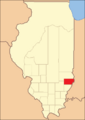
Lawrence County looked like this when it was first created in 1821.
-

How Lawrence County looked between 1824 and 1841.
-
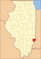
In 1841, Lawrence County became its current size when Richland County was formed.


Geography and Nature
Lawrence County covers a total area of about 374 square miles. Most of this area, about 372 square miles, is land. The rest, about 2 square miles, is water.
Weather in Lawrence County
| Weather chart for Lawrenceville, Illinois | |||||||||||||||||||||||||||||||||||||||||||||||
|---|---|---|---|---|---|---|---|---|---|---|---|---|---|---|---|---|---|---|---|---|---|---|---|---|---|---|---|---|---|---|---|---|---|---|---|---|---|---|---|---|---|---|---|---|---|---|---|
| J | F | M | A | M | J | J | A | S | O | N | D | ||||||||||||||||||||||||||||||||||||
|
2.6
36
18
|
2.5
42
22
|
3.6
53
32
|
4.3
65
42
|
5.1
75
52
|
4.1
84
61
|
4.7
88
65
|
3.7
86
63
|
3.2
80
54
|
3.2
68
42
|
4.3
54
33
|
3.2
42
23
|
||||||||||||||||||||||||||||||||||||
| temperatures in °F precipitation totals in inches source: The Weather Channel |
|||||||||||||||||||||||||||||||||||||||||||||||
|
Metric conversion
|
|||||||||||||||||||||||||||||||||||||||||||||||
The weather in Lawrence County changes throughout the year. In the county seat of Lawrenceville, January is usually the coldest month. Temperatures can drop to about 18°F. July is the warmest month, with temperatures reaching around 88°F.
However, temperatures can be extreme. The coldest temperature ever recorded was -26°F in January 1994. The hottest was 104°F in June 1988. The county also gets rain throughout the year. May usually has the most rain, while February is the driest month.
Roads and Transportation
Several important roads pass through Lawrence County. These roads help people travel and transport goods.
 U.S. Route 50
 Illinois Route 1
 Illinois Route 33
 Illinois Route 250
The county also has a public transportation system called the Rides Mass Transit District.
Neighboring Counties
Lawrence County shares its borders with several other counties:
- To the north is Crawford County.
- To the east is Knox County in Indiana.
- To the south is Wabash County.
- To the west is Richland County.
People of Lawrence County
| Historical population | |||
|---|---|---|---|
| Census | Pop. | %± | |
| 1830 | 3,668 | — | |
| 1840 | 7,092 | 93.3% | |
| 1850 | 6,121 | −13.7% | |
| 1860 | 9,214 | 50.5% | |
| 1870 | 12,533 | 36.0% | |
| 1880 | 13,663 | 9.0% | |
| 1890 | 14,693 | 7.5% | |
| 1900 | 16,523 | 12.5% | |
| 1910 | 22,661 | 37.1% | |
| 1920 | 21,380 | −5.7% | |
| 1930 | 21,885 | 2.4% | |
| 1940 | 21,075 | −3.7% | |
| 1950 | 20,539 | −2.5% | |
| 1960 | 18,540 | −9.7% | |
| 1970 | 17,522 | −5.5% | |
| 1980 | 17,807 | 1.6% | |
| 1990 | 15,972 | −10.3% | |
| 2000 | 15,452 | −3.3% | |
| 2010 | 16,833 | 8.9% | |
| 2020 | 15,280 | −9.2% | |
| 2023 (est.) | 14,813 | −12.0% | |
| U.S. Decennial Census 1790-1960 1900-1990 1990-2000 2010-2013 |
|||

In 2010, there were about 16,833 people living in Lawrence County. These people lived in about 6,130 homes. The average number of people in each home was 2.34. The average age of people in the county was 39.7 years old.
Most people in Lawrence County are white (87.3%). About 9.6% are black or African American. People of Hispanic or Latino origin made up 3.3% of the population. Many residents have German, American, Irish, or English family backgrounds.
The average income for a family in the county was about $45,565 per year. About 17.5% of all people in the county lived below the poverty line. This included about 26.9% of children under 18.
Towns and Villages
Lawrence County has several communities where people live.
Cities in Lawrence County
- Bridgeport
- Lawrenceville (This is the county seat!)
- St. Francisville
- Sumner
Villages in Lawrence County
Smaller Communities (Unincorporated)
These are smaller places that are not officially cities or villages.
Townships in Lawrence County
A township is a smaller area within a county, often with its own local government. Lawrence County is divided into nine townships:
- Allison
- Bond
- Bridgeport
- Christy
- Denison
- Lawrence
- Lukin
- Petty
- Russell
See also
 In Spanish: Condado de Lawrence (Illinois) para niños
