St. Francisville, Illinois facts for kids
Quick facts for kids
St. Francisville, Illinois
|
|
|---|---|

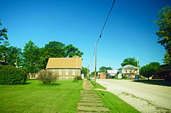
Main Street
|
|

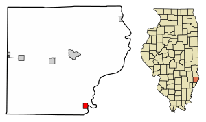
Location in Lawrence County, Illinois
|
|

Location of Illinois in the United States
|
|
| Country | United States |
| State | Illinois |
| County | Lawrence |
| Township | Denison |
| Area | |
| • Total | 0.78 sq mi (2.02 km2) |
| • Land | 0.74 sq mi (1.93 km2) |
| • Water | 0.03 sq mi (0.09 km2) |
| Elevation | 459 ft (140 m) |
| Population
(2020)
|
|
| • Total | 568 |
| • Density | 762.42/sq mi (294.39/km2) |
| Time zone | UTC-6 (CST) |
| • Summer (DST) | UTC-5 (CDT) |
| ZIP Code(s) |
62460
|
| Area code(s) | 618 |
| FIPS code | 17-66833 |
| GNIS feature ID | 2396489 |
| Wikimedia Commons | St. Francisville, Illinois |
St. Francisville, also known as Saint Francisville, is a city in Lawrence County, Illinois. It is located in the United States. In 2010, about 697 people lived there.
Contents
History of St. Francisville
St. Francisville started with a stockade (a fort made of strong wooden posts) built by Joseph Tougas. This was in the early 1810s. Later, in the mid-1830s, Tougas's widow planned out the city.
The city was named after St. Francis Xavier. This name showed the growing influence of Jesuit missionaries in the area. St. Francisville officially became a city in 1873.
Geography of St. Francisville
St. Francisville is in the southeastern part of Lawrence County. It is in the southeast corner of Denison Township. The city sits on the west bank of the Wabash River. This river forms the border between Illinois and Indiana.
St. Francisville is about 12 miles south of Lawrenceville. Lawrenceville is the main city, or county seat, of Lawrence County.
A bridge called the Wabash Cannon Ball Bridge is about 1.5 miles northeast of St. Francisville. It used to be a railroad bridge. Now, it is a one-lane toll bridge that crosses the Wabash River. This bridge is the most direct way to get to Vincennes, Indiana, which is about 9 miles northeast.
In 2010, St. Francisville covered a total area of about 0.78 square miles. Most of this area, about 0.75 square miles, is land. The remaining 0.034 square miles is water.
Population of St. Francisville
| Historical population | |||
|---|---|---|---|
| Census | Pop. | %± | |
| 1860 | 106 | — | |
| 1870 | 131 | 23.6% | |
| 1880 | 334 | 155.0% | |
| 1890 | 432 | 29.3% | |
| 1900 | 591 | 36.8% | |
| 1910 | 1,391 | 135.4% | |
| 1920 | 1,164 | −16.3% | |
| 1930 | 1,202 | 3.3% | |
| 1940 | 1,145 | −4.7% | |
| 1950 | 1,117 | −2.4% | |
| 1960 | 1,040 | −6.9% | |
| 1970 | 997 | −4.1% | |
| 1980 | 1,040 | 4.3% | |
| 1990 | 851 | −18.2% | |
| 2000 | 759 | −10.8% | |
| 2010 | 697 | −8.2% | |
| 2020 | 568 | −18.5% | |
| U.S. Decennial Census | |||
The population of St. Francisville changes over time. The table on the left shows how many people have lived in the city during different years.
According to the census in 2000, there were 759 people living in St. Francisville. These people lived in 317 households. About 221 of these households were families. The population density was about 1,017 people per square mile.
In 2010, the population of St. Francisville was 697 people. By 2020, the population was 568 people.
Economy
St. Francisville is known for a special type of popcorn. This popcorn is grown locally. It is called "Black Jewell" because of its dark kernels. The company that sells this popcorn says it was developed in the mid-1960s.
Notable People from St. Francisville
- Julian Morgenstern (1881–1976) was a rabbi, a professor, and the president of Hebrew Union College. He was born in St. Francisville.
- William Phipps was an actor and film producer. He moved to St. Francisville when he was six years old and grew up there.
See also
 In Spanish: St. Francisville para niños
 | George Robert Carruthers |
 | Patricia Bath |
 | Jan Ernst Matzeliger |
 | Alexander Miles |

