Ragsdale, Indiana facts for kids
Quick facts for kids
Ragsdale, Indiana
|
|
|---|---|

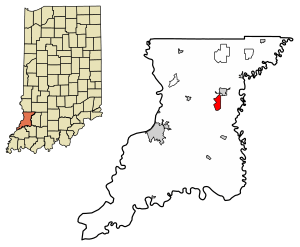
Location in Knox County, Indiana
|
|
| Country | United States |
| State | Indiana |
| County | Knox |
| Township | Washington |
| Area | |
| • Total | 2.23 sq mi (5.77 km2) |
| • Land | 2.23 sq mi (5.77 km2) |
| • Water | 0.00 sq mi (0.00 km2) |
| Elevation | 564 ft (172 m) |
| Population
(2020)
|
|
| • Total | 119 |
| • Density | 53.41/sq mi (20.62/km2) |
| ZIP code |
47573
|
| FIPS code | 18-62730 |
| GNIS feature ID | 441730 |
Ragsdale is a small community in Knox County, Indiana, United States. It is known as an unincorporated community, which means it doesn't have its own local government like a city or town. It is also a census-designated place, meaning the U.S. Census Bureau defines it for counting people. In 2020, about 119 people lived there.
Contents
Where is Ragsdale Located?
Ragsdale is found in the eastern part of Knox County. You can find its exact spot using coordinates: 38 degrees 44 minutes 45 seconds North and 87 degrees 19 minutes 30 seconds West. It is about 13 miles (21 kilometers) northeast of Vincennes, which is the main city and county seat. It's also the same distance northwest of Washington.
How Big is Ragsdale?
According to the U.S. Census Bureau, the Ragsdale area covers about 2.23 square miles (5.8 square kilometers). All of this area is land; there are no large bodies of water within its boundaries.
Who Lives in Ragsdale?
The number of people living in Ragsdale changes over time. The U.S. Decennial Census helps us keep track of this.
Population Changes Over Time
- In 2010, the population of Ragsdale was 129 people.
- By 2020, the population had slightly decreased to 119 people.
This information helps us understand how communities like Ragsdale grow or change.
See also
 In Spanish: Ragsdale (Indiana) para niños
 | Lonnie Johnson |
 | Granville Woods |
 | Lewis Howard Latimer |
 | James West |


