
Cannelton, Indiana facts for kids
Quick facts for kids
Cannelton, Indiana
|
|
|---|---|
| City of Cannelton | |

Cannelton's landmark cotton mill
|
|

Location of Cannelton in Perry County, Indiana.
|
|
| Country | United States |
| State | Indiana |
| County | Perry |
| Township | Troy |
| Area | |
| • Total | 1.57 sq mi (4.07 km2) |
| • Land | 1.48 sq mi (3.84 km2) |
| • Water | 0.09 sq mi (0.23 km2) |
| Elevation | 463 ft (141 m) |
| Population
(2020)
|
|
| • Total | 1,524 |
| • Density | 1,028.34/sq mi (397.11/km2) |
| Time zone | UTC-6 (CST) |
| • Summer (DST) | UTC-5 (CDT) |
| ZIP code |
47520
|
| Area code(s) | 812 |
| FIPS code | 18-10108 |
| GNIS feature ID | 2393730 |
Cannelton is a city in Perry County, Indiana. It is located along the Ohio River. In 2020, about 1,524 people lived there.
For many years, Cannelton was the smallest city in Indiana. It used to be the main town (county seat) for Perry County. Later, the county seat moved to Tell City.
Contents
History of Cannelton
Cannelton got its name in 1844. The name comes from "cannel coal," a special type of coal once dug up in the area. A post office has been open in Cannelton since 1844.
Several important buildings in Cannelton are listed on the National Register of Historic Places. These include the Cannelton Cotton Mill, the Cannelton Historic District, and St. Luke's Episcopal Church. These places are recognized for their historical value.
Where is Cannelton?
Cannelton covers about 1.58 square miles (4.09 square kilometers). Most of this area is land, about 1.48 square miles (3.83 square kilometers). A smaller part is water, about 0.10 square miles (0.26 square kilometers).
Cannelton's Weather
The weather in Cannelton has hot and humid summers. Winters are usually mild to cool. This type of weather is called a humid subtropical climate.
People of Cannelton
| Historical population | |||
|---|---|---|---|
| Census | Pop. | %± | |
| 1860 | 2,155 | — | |
| 1870 | 2,481 | 15.1% | |
| 1880 | 1,834 | −26.1% | |
| 1890 | 1,991 | 8.6% | |
| 1900 | 2,188 | 9.9% | |
| 1910 | 2,130 | −2.7% | |
| 1920 | 2,008 | −5.7% | |
| 1930 | 2,265 | 12.8% | |
| 1940 | 2,240 | −1.1% | |
| 1950 | 2,027 | −9.5% | |
| 1960 | 1,829 | −9.8% | |
| 1970 | 2,280 | 24.7% | |
| 1980 | 2,373 | 4.1% | |
| 1990 | 1,786 | −24.7% | |
| 2000 | 1,209 | −32.3% | |
| 2010 | 1,563 | 29.3% | |
| 2020 | 1,524 | −2.5% | |
| U.S. Decennial Census | |||
What the 2010 Census Showed
In 2010, there were 1,563 people living in Cannelton. There were 687 households and 385 families. The city had about 1,056 people per square mile (408 people per square kilometer).
Most people in Cannelton were White (97.4%). A small number were from other racial groups. About 0.8% of the population was Hispanic or Latino.
About 29.5% of households had children under 18. Many households (35.4%) were married couples. About 39.4% of households were individuals living alone. The average age in Cannelton was 38.5 years.
Learning in Cannelton
Cannelton has a public library. It is a part of the Perry County Public Library system.
Famous People from Cannelton
- William P. Birchler – A state representative.
- Tim Whelan – A film director, writer, producer, and actor.
Cool Places to Visit
- Cannelton Cotton Mill: Built in 1849, this mill was once the biggest factory building west of the Allegheny Mountains. It is now a National Historic Landmark.
- Cannelton Locks and Dam: This dam helps create a calm, 114-mile stretch of water on the Ohio River. It's great for boating and other water activities.
- Northwest Orient Airlines Flight 710 Memorial: This memorial is located about 8 miles east of town. It is off State Road 166.
Images for kids
-
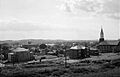
Cannelton, Indiana, 1974, looking southwest.
-
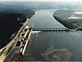
Cannelton Locks and Dam on the north bank of the Ohio River near Cannelton, Indiana.


See also
 In Spanish: Cannelton (Indiana) para niños
