
Perry County, Indiana facts for kids
Quick facts for kids
Perry County
|
|
|---|---|

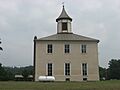
Old Perry County Courthouse in Rome
|
|

Location within the U.S. state of Indiana
|
|
 Indiana's location within the U.S. |
|
| Country | |
| State | |
| Founded | November 1, 1814 |
| Named for | Oliver Hazard Perry |
| Seat | Tell City |
| Largest city | Tell City |
| Area | |
| • Total | 386.29 sq mi (1,000.5 km2) |
| • Land | 381.73 sq mi (988.7 km2) |
| • Water | 4.56 sq mi (11.8 km2) 1.18%% |
| Population
(2020)
|
|
| • Total | 19,170 |
| • Estimate
(2023)
|
19,209 |
| • Density | 49.626/sq mi (19.161/km2) |
| Time zone | UTC−6 (Central) |
| • Summer (DST) | UTC−5 (CDT) |
| Congressional district | 8th |
| Indiana county number 62 | |
Perry County is a county located in the southwestern part of Indiana, a state in the United States. In 2020, about 19,170 people lived here. The main town and county seat is Tell City.
Perry County is known for its many hills and forests. It has over 60,000 acres (240 km2) of the Hoosier National Forest. The Ohio River Scenic Byway (which is Indiana State Road 66) runs along the county's southern edge. Interstate 64 crosses the northern part. Indiana State Road 37 connects these two major roads.
The county has three main towns: Tell City, Cannelton, and Troy. All three are located in Troy Township, which is in the southwestern corner of the county.
Perry County also has its own railroad, called the Hoosier Southern Rail Road. It's about 22 miles (35 km) long. This railroad connects the county's river port to the larger Norfolk Southern Rail Road line. This helps businesses move goods.
Contents
Weather and Temperatures in Perry County
| Weather chart for Tell City, Indiana | |||||||||||||||||||||||||||||||||||||||||||||||
|---|---|---|---|---|---|---|---|---|---|---|---|---|---|---|---|---|---|---|---|---|---|---|---|---|---|---|---|---|---|---|---|---|---|---|---|---|---|---|---|---|---|---|---|---|---|---|---|
| J | F | M | A | M | J | J | A | S | O | N | D | ||||||||||||||||||||||||||||||||||||
|
3.4
39
24
|
3.2
45
27
|
4.5
55
35
|
4.5
66
44
|
5.2
75
54
|
4.3
84
63
|
4.5
88
68
|
3.8
86
66
|
3.4
80
59
|
3
69
47
|
4.1
56
38
|
4
44
29
|
||||||||||||||||||||||||||||||||||||
| temperatures in °F precipitation totals in inches source: The Weather Channel |
|||||||||||||||||||||||||||||||||||||||||||||||
|
Metric conversion
|
|||||||||||||||||||||||||||||||||||||||||||||||
The weather in Perry County changes throughout the year. In Tell City, the average temperature in January is around 24°F (–4°C). In July, it's much warmer, with an average high of 88°F (31°C).
The coldest temperature ever recorded was –17°F (–27°C) in January 1985. The hottest was 106°F (41°C) in September 1954. The county gets a good amount of rain, with the most rain usually falling in May.
Geography of Perry County
Perry County covers a total area of about 386.29 square miles (999.9 km2). Most of this area, about 381.73 square miles (988.7 km2), is land. The rest, about 4.56 square miles (11.8 km2), is water.
Neighboring Counties
Perry County shares borders with several other counties:
- Crawford County (to the north)
- Spencer County (to the west)
- Dubois County (to the northwest)
- Meade County, Kentucky (to the southeast)
- Breckinridge County, Kentucky (to the south)
- Hancock County, Kentucky (to the southwest)
Main Roads and Highways
Here are the major roads that go through Perry County:
 Interstate 64
 Indiana State Road 37
 Indiana State Road 62
 Indiana State Road 66
 Indiana State Road 70
 Indiana State Road 145
 Indiana State Road 166
 Indiana State Road 545
Important Natural Areas
A part of the Hoosier National Forest is located within Perry County. This forest is a protected area with lots of trees and wildlife.
How Roads Connect Perry County
Interstate 64 crosses the northern part of the county. State Road 66 is a very busy road. It runs next to the three biggest towns and many tourist spots. This road is also called the Ohio River Scenic Byway.
State Road 37 connects Perry County to larger cities like Bloomington and Indianapolis. Other state roads include State Road 62, which runs close to I-64. State Road 145 winds through the western parts of the county.
State Road 166 is a short road that leads to the small community of Tobinsport. State Road 237 connects Cannelton directly to State Road 37 and has a bridge over the Ohio River. There's also a short section of State Road 545 near Troy. Finally, State Road 70 links State Road 37 with State Road 66.
History of Perry County
Perry County was officially created on November 1, 1814. This was two years before Indiana became a state. It was formed from parts of Warrick and Gibson Counties.
The county was named after Commodore Oliver Hazard Perry. He was a naval hero who won an important battle, the Battle of Lake Erie, in 1813. The Ohio River was very important for early settlers. People were drawn to Perry County because of its many natural resources and beautiful scenery.
Population Changes in Perry County
| Historical population | |||
|---|---|---|---|
| Census | Pop. | %± | |
| 1820 | 2,330 | — | |
| 1830 | 3,369 | 44.6% | |
| 1840 | 4,655 | 38.2% | |
| 1850 | 7,268 | 56.1% | |
| 1860 | 11,847 | 63.0% | |
| 1870 | 14,801 | 24.9% | |
| 1880 | 16,997 | 14.8% | |
| 1890 | 18,240 | 7.3% | |
| 1900 | 18,778 | 2.9% | |
| 1910 | 18,078 | −3.7% | |
| 1920 | 16,692 | −7.7% | |
| 1930 | 16,625 | −0.4% | |
| 1940 | 17,770 | 6.9% | |
| 1950 | 17,367 | −2.3% | |
| 1960 | 17,232 | −0.8% | |
| 1970 | 19,075 | 10.7% | |
| 1980 | 19,346 | 1.4% | |
| 1990 | 19,107 | −1.2% | |
| 2000 | 18,899 | −1.1% | |
| 2010 | 19,338 | 2.3% | |
| 2020 | 19,170 | −0.9% | |
| 2023 (est.) | 19,209 | −0.7% | |
| U.S. Decennial Census 1790-1960 1900-1990 1990-2000 2010 |
|||
In 2010, there were 19,338 people living in Perry County. There were 7,476 households and 5,020 families. The population density was about 50.7 people per square mile (19.6 people/km2).
Most people in the county were white (96.0%). About 2.4% were black or African American. A small number of people were Asian (0.4%) or American Indian (0.2%). About 1.0% of the population was of Hispanic or Latino background. Many people had German (37.8%), Irish (14.4%), American (11.6%), or English (8.7%) ancestry.
About 30.5% of households had children under 18 living with them. The average age of people in the county was 40.4 years old. The average income for a household was $47,697. About 10.4% of the population lived below the poverty line. This included 15.9% of those under 18.
Communities in Perry County
Cities and Towns
Smaller Communities (Unincorporated)
Townships in Perry County
A township is a small area within a county. Here are the townships in Perry County:
- Anderson
- Clark
- Leopold
- Oil
- Tobin
- Troy
- Union
Schools in Perry County
Children in Perry County attend schools in these districts:
- Cannelton City Schools
- Perry Central Community School Corporation
- Tell City-Troy Township School Corporation
Images for kids
-
Old Perry County Courthouse in Rome
See also
 In Spanish: Condado de Perry (Indiana) para niños
