
Breckinridge County, Kentucky facts for kids
Quick facts for kids
Breckinridge County
|
|||
|---|---|---|---|

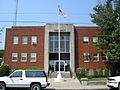
Breckinridge County, Kentucky courthouse in Hardinsburg
|
|||
|
|||

Location within the U.S. state of Kentucky
|
|||
 Kentucky's location within the U.S. |
|||
| Country | |||
| State | |||
| Founded | 1799 | ||
| Named for | John Breckinridge | ||
| Seat | Hardinsburg | ||
| Largest city | Hardinsburg | ||
| Area | |||
| • Total | 586 sq mi (1,520 km2) | ||
| • Land | 567 sq mi (1,470 km2) | ||
| • Water | 18 sq mi (50 km2) 3.2%% | ||
| Population
(2020)
|
|||
| • Total | 20,432 | ||
| • Estimate
(2023)
|
21,124 |
||
| • Density | 34.867/sq mi (13.462/km2) | ||
| Time zone | UTC−6 (Central) | ||
| • Summer (DST) | UTC−5 (CDT) | ||
| Congressional district | 2nd | ||


Breckinridge County is a county in Kentucky. It's like a big neighborhood with its own local government. As of 2020, about 20,432 people live there. The main town and county seat is Hardinsburg, Kentucky.
The county is named after John Breckinridge. He was an important person in Kentucky's early days. He worked as a lawyer for the state and was a United States Senator. Breckinridge County was the 38th county formed in Kentucky. Today, it is a "wet county," which means you can buy alcohol there. For a long time before 2013, it was a "dry county."
Contents
History of Breckinridge County
Early Settlers and Native Americans
In 1779, a settler named Sinclair Hardin was killed by Shawnee Native Americans. This happened while he was getting a drink at Big Springs. He was one of the first white settlers to be killed in the area. Native American groups were a threat to settlers for many years.
In 1786, some settlers from the area joined a fight against the Shawnee. This battle was called the Battle of Saline Creek. It happened in Illinois and was a very short but intense fight. Captain William Hardin led the settlers. They won the battle and captured some items from the Shawnee.
How the County Was Formed
Breckinridge County was officially created in 1799. The land for the county came from Hardin County. It was the 38th county to be formed in Kentucky.
Early leaders of the county included William Comstock, who was like a chief judge. Jo Allen was the county clerk, and Ben Huff was the sheriff.
Abraham Lincoln's Journey Through the County
When Abraham Lincoln was a young boy, his family traveled through Breckinridge County. This was in 1816, when Abe was about seven or eight years old. His father, Thomas Lincoln, was moving their family from their home in Kentucky.
The Lincolns traveled along old pioneer trails. They passed through places like Vine Grove and Flaherty. They also stopped at Big Spring, where three counties meet.
The family was very poor at the time. They sometimes paid for a place to stay by working. In Hardinsburg, they stayed in a small cabin. Local people were kind and gave them food and a cow for milk.
After a few weeks, the Lincolns continued their journey. They crossed the Ohio River at Cloverport. They used a ferry made of logs to get to Indiana. This was a big step for the Lincoln family as they moved to their new home.
Civil War Times
During the American Civil War, Breckinridge County saw some action. Confederate soldiers burned the local courthouse. Union troops were using it as a place to stay. Luckily, most of the important county records were saved.
In 1865, a famous Confederate fighter named Jerome Clarke was captured near the county line.
Coal and Progress
In the 1800s, the Victoria Coal Mines were important. They were named after Queen Victoria of the United Kingdom. These mines were among the first to make coal oil. This oil was even sent to Great Britain to light Buckingham Palace!
Important People and Events
Wiley Blount Rutledge, Jr. was born in Breckinridge County in 1894. He later became a Justice on the United States Supreme Court.
In the 1950s, Rough River Dam State Resort Park was built. This park is a popular place for fun and relaxation.
The county courthouse had another fire in 1958. It almost destroyed the records again.
Breckinridge County High School has a proud history in basketball. Their boys' teams won state championships in 1965 and 1995.
The Breckinridge County Archives started in 1984. It was the first state-funded place to keep old records in the U.S. It's a great place for people to research their family history.
Geography of Breckinridge County
Breckinridge County covers about 586 square miles. Most of this area is land, about 567 square miles. The rest, about 18 square miles, is water.
Neighboring Counties
Breckinridge County shares borders with these other counties:
- Perry County, Indiana (northwest)
- Meade County (northeast)
- Hardin County (east)
- Grayson County (south)
- Ohio County (southwest)
- Hancock County (west)
Population of Breckinridge County
The number of people living in Breckinridge County has changed over time. Here's how the population has grown:
| Historical population | |||
|---|---|---|---|
| Census | Pop. | %± | |
| 1810 | 3,430 | — | |
| 1820 | 7,485 | 118.2% | |
| 1830 | 7,345 | −1.9% | |
| 1840 | 8,944 | 21.8% | |
| 1850 | 10,593 | 18.4% | |
| 1860 | 13,236 | 25.0% | |
| 1870 | 13,440 | 1.5% | |
| 1880 | 17,486 | 30.1% | |
| 1890 | 21,034 | 20.3% | |
| 1900 | 20,534 | −2.4% | |
| 1910 | 21,034 | 2.4% | |
| 1920 | 19,652 | −6.6% | |
| 1930 | 17,368 | −11.6% | |
| 1940 | 17,744 | 2.2% | |
| 1950 | 15,528 | −12.5% | |
| 1960 | 14,734 | −5.1% | |
| 1970 | 14,789 | 0.4% | |
| 1980 | 16,861 | 14.0% | |
| 1990 | 16,312 | −3.3% | |
| 2000 | 18,648 | 14.3% | |
| 2010 | 20,059 | 7.6% | |
| 2020 | 20,432 | 1.9% | |
| 2023 (est.) | 21,124 | 5.3% | |
| U.S. Decennial Census 1790-1960 1900-1990 1990-2000 2010-2020 |
|||
Education in Breckinridge County
Schools for Kids
There are two main school districts in the county:
- Breckinridge County School District
- Cloverport Independent School District
There is also a private school:
- Saint Romuald Interparochial School
Public Library
The Breckinridge County Public Library is in Hardinsburg. It's a great place to find books and learn new things.
Higher Education History
A Roman Catholic seminary school was in the Mount Merino area from 1838 to 1843. It was like a high school for religious studies.
A Methodist college called Kingswood College was in Kingswood. It operated from 1906 to 1934. It closed during the Great Depression.
Towns and Communities
Famous People from Breckinridge County
| Name | Achievements |
|---|---|
| Alfred "Butch" Beard | Professional basketball player and coach |
| David "Big Dave" DeJernett | Professional basketball player |
| Philip Leget Edwards | American educator |
| Joseph Holt | High-ranking lawyer for the U.S. Army |
| Served as the U.S. Attorney General | |
| Served as the U.S. Secretary of War | |
| Was in charge of U.S. Patents | |
| Served as the U.S. Postmaster General | |
| Bobbi Jordan | American actress |
| John Alexander McClernand | Union General during the American Civil War |
| Charles Harwood Moorman | Judge for Kentucky and U.S. federal courts |
| Wiley Blount Rutledge | Justice of the Supreme Court of the United States |
| George W. Swink | Businessman |
| Joe Wright | Leader in the Kentucky State Senate |
Images for kids
-

Flag of Breckinridge County
-
Seal of Breckinridge County
-
Breckinridge County, Kentucky courthouse in Hardinsburg
See also
 In Spanish: Condado de Breckinridge para niños
