Ohio County, Kentucky facts for kids
Quick facts for kids
Ohio County
|
|
|---|---|

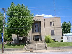
Ohio County Courthouse in Hartford
|
|

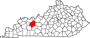
Location within the U.S. state of Kentucky
|
|
 Kentucky's location within the U.S. |
|
| Country | |
| State | |
| Founded | December 17, 1798 |
| Named for | The Ohio River |
| Seat | Hartford |
| Largest city | Beaver Dam |
| Area | |
| • Total | 596 sq mi (1,540 km2) |
| • Land | 587 sq mi (1,520 km2) |
| • Water | 9.0 sq mi (23 km2) 1.5% |
| Population
(2020)
|
|
| • Total | 23,772 |
| • Estimate
(2023)
|
23,626 |
| • Density | 39.89/sq mi (15.400/km2) |
| Time zone | UTC−6 (Central) |
| • Summer (DST) | UTC−5 (CDT) |
| Congressional district | 2nd |
Ohio County is a place in the state of Kentucky, USA. It is a type of local government area called a county. In 2020, about 23,772 people lived there.
The main town where the county government is located is Hartford. The biggest city in Ohio County is Beaver Dam. The county gets its name from the Ohio River, which used to be its northern border.
Contents
History of Ohio County
Ohio County was created in 1798. Land was taken from Hardin County to form it. It was the 35th county to be formed in Kentucky.
The county was named after the Ohio River. This river was once its northern boundary. However, in 1829, parts of the northern area were used to create Daviess County and Hancock County.
The first settlements in Ohio County were Barnetts Station and Hartford. During the American Civil War in 1865, the courthouse in Hartford was burned. This happened because soldiers from the Union army were using it. Luckily, the important county records were saved before the fire.
Ohio County is also known for its coal mines. It was once the second-largest coal-producing county in Kentucky.
Geography of Ohio County
Ohio County covers about 596 square miles. Most of this area, about 587 square miles, is land. The rest, about 9 square miles, is water. This makes it the fifth-largest county in Kentucky by land area.
The county is part of the Western Coal Field region of Kentucky. Much of Ohio County has farms. The eastern and northern parts of the county have gentle, rolling hills.
The Rough River flows through the county. The Green River runs along its southwestern border.
Neighboring Counties
Ohio County shares borders with several other counties:
- Hancock County (to the north)
- Breckinridge County (to the northeast)
- Grayson County (to the east)
- Butler County (to the southeast)
- Muhlenberg County (to the southwest)
- McLean County (to the west)
- Daviess County (to the northwest)
People of Ohio County
| Historical population | |||
|---|---|---|---|
| Census | Pop. | %± | |
| 1800 | 1,223 | — | |
| 1810 | 3,792 | 210.1% | |
| 1820 | 3,879 | 2.3% | |
| 1830 | 4,715 | 21.6% | |
| 1840 | 6,592 | 39.8% | |
| 1850 | 9,749 | 47.9% | |
| 1860 | 12,209 | 25.2% | |
| 1870 | 15,561 | 27.5% | |
| 1880 | 19,669 | 26.4% | |
| 1890 | 22,946 | 16.7% | |
| 1900 | 27,287 | 18.9% | |
| 1910 | 27,642 | 1.3% | |
| 1920 | 26,473 | −4.2% | |
| 1930 | 24,469 | −7.6% | |
| 1940 | 24,421 | −0.2% | |
| 1950 | 20,840 | −14.7% | |
| 1960 | 17,725 | −14.9% | |
| 1970 | 18,790 | 6.0% | |
| 1980 | 21,765 | 15.8% | |
| 1990 | 21,105 | −3.0% | |
| 2000 | 22,916 | 8.6% | |
| 2010 | 23,842 | 4.0% | |
| 2020 | 23,772 | −0.3% | |
| 2023 (est.) | 23,626 | −0.9% | |
| U.S. Decennial Census 1790-1960 1900-1990 1990-2000 2010-2020 |
|||
In 2000, there were 22,916 people living in Ohio County. The population density was about 39 people per square mile.
About 24.9% of the people were under 18 years old. About 14.4% were 65 years or older. The average age was 38 years.
A big part of the jobs in Ohio County used to be in coal mining. In 2019, many coal miners lost their jobs when mines closed.
Towns and Places
Ohio County has several cities and other communities.
Cities
- Beaver Dam
- Centertown
- Fordsville
- Hartford (the county seat)
- McHenry
- Rockport
Census-designated place
- Pleasant Ridge (partially in Daviess County)
Other Unincorporated Places
North
- Adaburg
- Aetnaville
- Beda
- Buford
- Coffman
- Deanefield
- Haynesville
- Heflin
- Herbert
- Magan
- Narrows
- Reynolds Station (partially in Hancock County)
- Shreve
- Silver Beach
- Taffy
South
- Baizetown
- Ceralvo
- Cool Springs
- Cromwell
- Dundee
- Echols
- Equality
- Horse Branch
- Matanzas
- Neafus (partially in Grayson County, mostly in Butler County)
- Olaton
- Prentiss
- Rosine
- Select
- Simmons
- Shultztown
- Smallhous
- Wysox
Media in Ohio County
Ohio County gets its radio and TV signals from nearby areas. Charter Communications provides cable television services under the name Spectrum.
The county has its own local media too. There is a weekly newspaper called The Ohio County Monitor. There is also a radio station, WXMZ, which plays oldies music. Another radio station, WEKV, has its broadcasting equipment located near Pleasant Ridge.
Famous People from Ohio County
Many interesting people have come from Ohio County:
- Ramsey Carpenter - She was Miss Kentucky in 2014.
- James Earp - A lawman and soldier, part of the famous Earp family.
- Newton Earp - A soldier in the Civil War.
- Virgil Earp - Another lawman and soldier from the Earp family.
- John Givens - The first coach for the Kentucky Colonels basketball team.
- Bill Monroe - Known as the "father of bluegrass music".
- George H. Tichenor - He invented Dr. Tichenor's antiseptic.
- Pendleton Vandiver - Also known as 'Uncle Pen', he inspired Bill Monroe's music. He lived in Rosine.
- Ray Chapman - The only Major League Baseball player ever killed during a game.
- The Crabb Family - A family group that sings Southern gospel music.
See also
 In Spanish: Condado de Ohio (Kentucky) para niños
 | Delilah Pierce |
 | Gordon Parks |
 | Augusta Savage |
 | Charles Ethan Porter |

