McLean County, Kentucky facts for kids
Quick facts for kids
McLean County
|
|
|---|---|

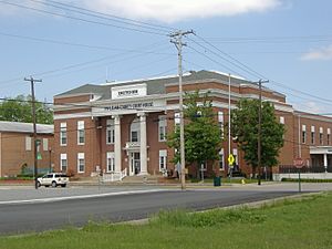
McLean County Courthouse in Calhoun
|
|

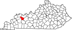
Location within the U.S. state of Kentucky
|
|
 Kentucky's location within the U.S. |
|
| Country | |
| State | |
| Founded | 1854 |
| Named for | Alney McLean |
| Seat | Calhoun |
| Largest city | Livermore |
| Area | |
| • Total | 256 sq mi (660 km2) |
| • Land | 252 sq mi (650 km2) |
| • Water | 3.8 sq mi (10 km2) 1.5% |
| Population
(2020)
|
|
| • Total | 9,152 |
| • Estimate
(2023)
|
9,054 |
| • Density | 35.75/sq mi (13.803/km2) |
| Time zone | UTC−6 (Central) |
| • Summer (DST) | UTC−5 (CDT) |
| Congressional district | 2nd |
McLean County is a county located in the state of Kentucky. In 2020, about 9,152 people lived here. The main town, or county seat, is Calhoun. The biggest city in the county is Livermore. McLean County is part of the larger Owensboro area.
Contents
History
McLean County was created on February 6, 1854. It was formed from parts of nearby Daviess, Ohio, and Muhlenberg Counties. The county is named after Judge Alney McLean. He was also the founder of Greenville.
Geography
McLean County covers a total area of 256 square miles. Most of this area, 252 square miles, is land. The remaining 3.8 square miles is water.
Features
McLean County is located in the Western Coal Fields region of Kentucky.
The Green River flows through the county from the southeast to the northwest. This is the longest river that stays completely within Kentucky. You can cross the Green River on bridges in Calhoun, Livermore, and near Island and Beech Grove. Boats can travel on the Green River throughout McLean County. There is a special lock and dam system at Calhoun that helps boats navigate.
Neighboring Counties
- Henderson County (northwest)
- Daviess County (northeast)
- Ohio County (east)
- Muhlenberg County (south)
- Hopkins County (southwest)
- Webster County (west)
Population Information
| Historical population | |||
|---|---|---|---|
| Census | Pop. | %± | |
| 1860 | 6,144 | — | |
| 1870 | 7,614 | 23.9% | |
| 1880 | 9,293 | 22.1% | |
| 1890 | 9,887 | 6.4% | |
| 1900 | 12,448 | 25.9% | |
| 1910 | 13,241 | 6.4% | |
| 1920 | 12,502 | −5.6% | |
| 1930 | 11,072 | −11.4% | |
| 1940 | 11,446 | 3.4% | |
| 1950 | 10,021 | −12.4% | |
| 1960 | 9,355 | −6.6% | |
| 1970 | 9,062 | −3.1% | |
| 1980 | 10,090 | 11.3% | |
| 1990 | 9,628 | −4.6% | |
| 2000 | 9,938 | 3.2% | |
| 2010 | 9,531 | −4.1% | |
| 2020 | 9,152 | −4.0% | |
| 2023 (est.) | 9,054 | −5.0% | |
| U.S. Decennial Census 1790-1960 1900-1990 1990-2000 2010-2021 |
|||
In 2000, there were 9,938 people living in McLean County. There were about 3,984 households. The population density was around 39 people per square mile. Most people in the county were White (98.58%).
The average household had about 2.47 people. The average family had about 2.93 people. About 24.20% of the population was under 18 years old. The median age was 38 years.
Education
McLean County has one public school district for the whole county. It serves about 1,300 students. There is one high school, one middle school, and three elementary schools.
McLean County High School has around 400 students. Its first class graduated in 1973. McLean County Middle School has about 350 students. Both schools are located near Calhoun. Their mascot is the cougar.
The county also has three elementary schools for grades K-5. These are in the towns of Calhoun, Livermore, and Sacramento. Calhoun Elementary has about 250 students, and its mascot is the bulldog. Livermore Elementary has around 200 students, and its mascot is the yellow jacket. Sacramento Elementary has about 100 students, and its mascot is the blue jay. Sacramento Elementary was renamed Marie Gatton Phillips Elementary School.
Many county residents, between 350 and 400, are also studying at colleges or universities.
Media
McLean County has its own weekly newspaper, called the McLean County News.
For radio and television, McLean County is part of the Owensboro, Kentucky, radio market. It is also part of the Evansville, Indiana, television market. Spectrum provides cable television services in the county.
Communities
Cities
- Calhoun (county seat)
- Island
- Livermore (largest community)
- Sacramento
Census-designated place
- Beech Grove
Other Unincorporated Communities
North McLean
South McLean
- Buttonsberry
- Poplar Grove
- Rumsey
- Semiway
- Station
- Underwood
See also
 In Spanish: Condado de McLean (Kentucky) para niños
 | Anna J. Cooper |
 | Mary McLeod Bethune |
 | Lillie Mae Bradford |

