Hopkins County, Kentucky facts for kids
Quick facts for kids
Hopkins County
|
|
|---|---|

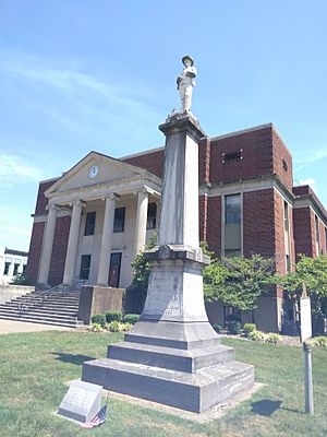
Hopkins County Courthouse in Madisonville
|
|

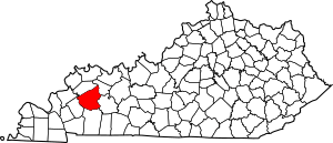
Location within the U.S. state of Kentucky
|
|
 Kentucky's location within the U.S. |
|
| Country | |
| State | |
| Founded | 1806 |
| Named for | Samuel Hopkins |
| Seat | Madisonville |
| Largest city | Madisonville |
| Area | |
| • Total | 554 sq mi (1,430 km2) |
| • Land | 542 sq mi (1,400 km2) |
| • Water | 12 sq mi (30 km2) 2.2%% |
| Population
(2020)
|
|
| • Total | 45,423 |
| • Estimate
(2023)
|
44,929 |
| • Density | 81.99/sq mi (31.657/km2) |
| Time zone | UTC−6 (Central) |
| • Summer (DST) | UTC−5 (CDT) |
| Congressional district | 1st |
Hopkins County is a county in western Kentucky. In 2020, about 45,423 people lived there. The main city and county seat is Madisonville.
Hopkins County was created on December 9, 1806. It was named after General Samuel Hopkins. He was a brave officer in both the American Revolutionary War and the War of 1812. Later, he became a Kentucky lawmaker and a U.S. Congressman.
The land in Hopkins County changes a lot. You can find flat areas along the Pond River, Tradewater River, and Green River. There are also hilly and rolling lands, especially in the southern and central parts.
Coal mines are active in the southern part of the county. Farming is very important in the northern part. Farmers grow crops like soybeans, corn, and tobacco. Besides coal, the county also has oil and natural gas.
Contents
History of Hopkins County
The first people to live here were Native Americans long ago. They hunted, farmed, and built homes. One old settlement was a stone building on Fort Ridge. It was later removed due to coal mining.
Some of the first European settlers were soldiers from the American Revolutionary War. They received land grants from Virginia for their service. One famous person was Baron Von Steuben. He was a Prussian officer who helped train George Washington's army. He received thousands of acres in the county. A salt spring on his land became known as Steuben's Lick. A community called Manitou grew up around it.
Early roads in the county often followed animal trails. These trails led to important salt and mineral springs. Major paths connected Madisonville to other towns like Henderson, Hopkinsville, and Russellville. Other trails led to mills and river crossings.
In 1829, the town of Ashbyburg was officially formed. It was on the Green River and became a busy steamboat stop in the 1800s. Other early towns included Nebo, Kentucky and Charleston, Kentucky. Charleston was named after "Free Charles," a freedman who ran a local tavern.
The Civil War and Beyond
Hopkins County was divided during the American Civil War. Some people supported the Union, while others joined the Confederate side. In 1864, Confederate soldiers burned the courthouse in Madisonville. This happened because Union soldiers were using it.
After the war, farming was the main job in Hopkins County. Tobacco was the most important crop. Around 1837, a local blacksmith named James Woolfolk found coal on his land.
Growth After the Civil War
The first coal mine in the county opened in 1869. It was started by John Bayless Earle, and the town of Earlington, Kentucky is named after him. Coal mining became a big industry when the Louisville & Nashville Railroad built its line through Madisonville in 1870.
Two years later, another railroad, the Elizabethtown and Paducah Railroad, came into the county. Many new towns started as railroad stops. These included Crofton, Hanson, Mortons Gap, Nortonville, and White Plains. Dawson Springs became a popular health resort in the 1880s. However, its popularity faded by the 1930s.
Modern Economy and Politics
By 1970, Hopkins County was one of the biggest coal producers in Kentucky. It also ranked high in oil production. The building of major highways, like the Pennyrile Parkway and the Western Kentucky Parkway, helped the county's economy grow.
Today, coal and oil businesses are still important employers. Farms also cover a large part of the county's land.
Geography of Hopkins County
The United States Census Bureau says Hopkins County covers about 554 square miles. Most of this is land (542 square miles), and a small part is water (12 square miles).
Neighboring Counties
Hopkins County shares borders with these counties:
- Webster County (northwest)
- McLean County (northeast)
- Muhlenberg County (southeast)
- Christian County (south)
- Caldwell County (southwest)
People of Hopkins County
| Historical population | |||
|---|---|---|---|
| Census | Pop. | %± | |
| 1810 | 2,964 | — | |
| 1820 | 5,322 | 79.6% | |
| 1830 | 6,763 | 27.1% | |
| 1840 | 9,171 | 35.6% | |
| 1850 | 12,441 | 35.7% | |
| 1860 | 11,875 | −4.5% | |
| 1870 | 13,827 | 16.4% | |
| 1880 | 19,122 | 38.3% | |
| 1890 | 23,505 | 22.9% | |
| 1900 | 30,995 | 31.9% | |
| 1910 | 34,291 | 10.6% | |
| 1920 | 34,133 | −0.5% | |
| 1930 | 37,449 | 9.7% | |
| 1940 | 37,789 | 0.9% | |
| 1950 | 38,815 | 2.7% | |
| 1960 | 38,458 | −0.9% | |
| 1970 | 38,167 | −0.8% | |
| 1980 | 46,174 | 21.0% | |
| 1990 | 46,126 | −0.1% | |
| 2000 | 46,519 | 0.9% | |
| 2010 | 46,920 | 0.9% | |
| 2020 | 45,423 | −3.2% | |
| 2023 (est.) | 44,929 | −4.2% | |
| U.S. Decennial Census 1790-1960 1900-1990 1990-2000 2010-2020 |
|||
In 2000, there were 46,519 people living in Hopkins County. Most people were White (92.02%), and 6.21% were Black or African American. About 0.91% of the population was Hispanic or Latino.
The average family size was about 2.91 people. The median age in the county was 38 years old. This means half the people were younger than 38, and half were older.
The median income for a household was $30,868. This is the middle income for all families living there. About 16.50% of the people lived below the poverty line. This included 24.40% of children under 18.
Education in Hopkins County
Two public school districts serve the county. Hopkins County Schools covers most of the area. The Dawson Springs Independent School District serves most of Dawson Springs. This district has one school, Dawson Springs Community School, for all grades from kindergarten to 12th grade.
In 2017, Hopkins County Schools made a rule that no tobacco products are allowed on school grounds. This includes e-cigarettes and vapor products. The rule applies to outdoor events and even inside cars on school property.
Elementary Schools
- Grapevine Elementary
- Hanson Elementary
- Jesse Stuart Elementary
- Pride Elementary
- Southside Elementary
- West Broadway Elementary
- West Hopkins School
- Dawson Springs Community School
- Christ The King Elementary
Middle Schools
- Browning Springs Middle School
- James Madison Middle School
- South Hopkins Middle School
- West Hopkins School
- Dawson Springs Community School
High Schools
- Hopkins County Central High School
- Madisonville North Hopkins High School
- Dawson Springs Community School
- Grace Baptist
Community College
- Madisonville Community College
Media
- The Madisonville Messenger is a daily newspaper. It has been around since 1917. It covers news for Hopkins, Webster, and Muhlenberg counties.
Communities in Hopkins County
Cities
Census-designated place
Unincorporated communities
- Anton
- Ashbyburg
- Barnsley
- Charleston
- Coiltown
- Dalton
- Daniel Boone
- Fiddle Bow
- Fies
- Grapevine
- Hecla
- Ilsley
- Richland
- Sixth Vein
- Wicks Well
See also
 In Spanish: Condado de Hopkins (Kentucky) para niños
 | Precious Adams |
 | Lauren Anderson |
 | Janet Collins |

