White Plains, Kentucky facts for kids
Quick facts for kids
White Plains, Kentucky
|
|
|---|---|

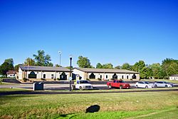
City Hall
|
|
| Nickname(s):
little prairie
|
|

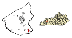
Location of White Plains in Hopkins County, Kentucky.
|
|
| Country | United States |
| State | Kentucky |
| County | Hopkins |
| Area | |
| • Total | 3.33 sq mi (8.62 km2) |
| • Land | 3.25 sq mi (8.42 km2) |
| • Water | 0.08 sq mi (0.20 km2) |
| Elevation | 417 ft (127 m) |
| Population
(2020)
|
|
| • Total | 829 |
| • Density | 254.92/sq mi (98.41/km2) |
| Time zone | UTC-6 (Central (CST)) |
| • Summer (DST) | UTC-5 (CDT) |
| ZIP code |
42464
|
| Area code(s) | 270 & 364 |
| FIPS code | 21-82722 |
| GNIS feature ID | 0506635 |
White Plains is a small city located in Hopkins County, Kentucky, in the United States. It is a "home rule-class city," meaning it has its own local government. In 2020, about 829 people lived there.
History of White Plains
White Plains was started in 1853. At first, it was called "Little Prairie."
When the railroad arrived in 1870, Little Prairie became a shipping spot. It served a community further south called "White Plains." This southern community was in Christian County.
Because of this, Little Prairie became known as "White Plains Station." Sometimes people called it "New White Plains." Later, the postmaster in Christian County changed that community's name to "Fruit Hill." After that, the "New" was dropped from the Hopkins County city's name, and it became just White Plains.
Where is White Plains?
White Plains is in the southeastern part of Hopkins County. You can find it at these coordinates: 37°11′4″N 87°23′5″W / 37.18444°N 87.38472°W.
U.S. Route 62 is a main road that goes through the northern part of the city. If you go east on this road, you will reach Greenville in about 13 miles. If you go west, you will get to Nortonville in about 4 miles.
The United States Census Bureau says that White Plains covers a total area of about 8.24 square kilometers (3.18 square miles). Most of this area is land, about 8.05 square kilometers (3.11 square miles). A small part, about 0.19 square kilometers (0.07 square miles), is water.
How Many People Live Here?
The number of people living in White Plains has changed over the years. The U.S. Census counts the population every ten years.
Here is how the population has grown and changed:
| Historical population | |||
|---|---|---|---|
| Census | Pop. | %± | |
| 1880 | 35 | — | |
| 1890 | 59 | 68.6% | |
| 1900 | 200 | 239.0% | |
| 1910 | 281 | 40.5% | |
| 1920 | 315 | 12.1% | |
| 1930 | 350 | 11.1% | |
| 1940 | 382 | 9.1% | |
| 1950 | 385 | 0.8% | |
| 1960 | 359 | −6.8% | |
| 1970 | 729 | 103.1% | |
| 1980 | 859 | 17.8% | |
| 1990 | 598 | −30.4% | |
| 2000 | 800 | 33.8% | |
| 2010 | 884 | 10.5% | |
| 2020 | 829 | −6.2% | |
| U.S. Decennial Census | |||
In 2000, there were 800 people living in White Plains. There were 295 households, which are groups of people living together. About 225 of these were families.
The average household had about 2.71 people. The average family had about 3.14 people.
The population was spread out by age. About 27.1% of the people were under 18 years old. About 9.5% were 65 years old or older. The average age in the city was 33 years.
See also
 In Spanish: White Plains (Kentucky) para niños
 | Stephanie Wilson |
 | Charles Bolden |
 | Ronald McNair |
 | Frederick D. Gregory |

