Hanson, Kentucky facts for kids
Quick facts for kids
Hanson, Kentucky
|
|
|---|---|

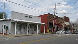
Main Street downtown
|
|

Location of Hanson in Hopkins County, Kentucky.
|
|
| Country | United States |
| State | Kentucky |
| County | Hopkins |
| Founded | 1869 |
| Incorporated | 1873 |
| Named for | a local railroad employee |
| Area | |
| • Total | 2.37 sq mi (6.13 km2) |
| • Land | 2.35 sq mi (6.10 km2) |
| • Water | 0.01 sq mi (0.03 km2) |
| Elevation | 436 ft (133 m) |
| Population
(2020)
|
|
| • Total | 758 |
| • Density | 321.87/sq mi (124.27/km2) |
| Time zone | UTC-6 (CST) |
| • Summer (DST) | UTC-5 (CDT) |
| ZIP Code |
42413
|
| Area code(s) | 270 & 364 |
| FIPS code | 21-34390 |
| GNIS feature ID | 0493695 |
Hanson is a small city in Hopkins County, Kentucky, in the United States. It is known as a "home rule-class city," which means it has its own local government. In 2020, about 758 people lived there.
The Hanson Historic District is a special area in the city. It shows what the town looked like a long time ago. The electricity for Hanson comes from companies called Kentucky Utilities and Kenergy.
History of Hanson
Hanson was founded in 1869. Two local landowners, Robert Eastwood and Roland Gooch, gave 50 acres of land for the town. They wanted it to be a stop for the Evansville, Henderson, and Nashville Railroad.
The city was planned and named after a railroad engineer and surveyor named Henry B. Hanson. The town got its own post office on December 7, 1869. It officially became a city on March 31, 1873.
The original railroad company was bought by other companies over the years. First, the St. Louis and South Eastern Railway bought it in 1872. Then, the L&N bought it in 1879.
In 1889, a big fire destroyed most of the city. The buildings you see in the historic district today were built after that fire. Today, the old L&N railroad lines are part of CSX Transportation. They still use a side track in Hanson.
Where is Hanson Located?
Hanson is in the northern part of Hopkins County. You can find it at these coordinates: 37°25′4″N 87°28′50″W / 37.41778°N 87.48056°W.
U.S. Route 41 (also called Hanson Road) goes right through the middle of the town. Interstate 69 passes through the eastern side, and you can get off at Exit 120.
Madisonville, which is the main city of the county, is about 6 miles south of Hanson. Henderson is about 32 miles north. You can reach both cities using the highways.
According to the United States Census Bureau, Hanson covers about 2.37 square miles (6.13 square kilometers). Only a very small part of this area, about 0.01 square miles (0.03 square kilometers), is water.
Hanson's Population
| Historical population | |||
|---|---|---|---|
| Census | Pop. | %± | |
| 1880 | 217 | — | |
| 1890 | 376 | 73.3% | |
| 1900 | 549 | 46.0% | |
| 1910 | 509 | −7.3% | |
| 1920 | 216 | −57.6% | |
| 1930 | 411 | 90.3% | |
| 1940 | 364 | −11.4% | |
| 1950 | 393 | 8.0% | |
| 1960 | 376 | −4.3% | |
| 1970 | 378 | 0.5% | |
| 1980 | 485 | 28.3% | |
| 1990 | 450 | −7.2% | |
| 2000 | 625 | 38.9% | |
| 2010 | 742 | 18.7% | |
| 2020 | 758 | 2.2% | |
| U.S. Decennial Census | |||
The number of people living in Hanson has changed over the years. In 2000, there were 625 people. By 2010, the population grew to 742 people. The most recent count in 2020 showed 758 people living in Hanson.
Most people living in Hanson are White. A small number of people are from other racial backgrounds, including Black and Asian. Some people are also of Hispanic or Latino heritage.
The average age of people in Hanson in 2000 was 39 years old. About 26% of the population was under 18 years old. About 11.5% of the people were 65 years or older.
See also

- In Spanish: Hanson (Kentucky) para niños
 | Audre Lorde |
 | John Berry Meachum |
 | Ferdinand Lee Barnett |

