Crofton, Kentucky facts for kids
Quick facts for kids
Crofton, Kentucky
|
|
|---|---|
| Motto(s):
Small Town... Big Heart
|
|

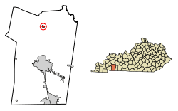
Location of Crofton in Christian County, Kentucky.
|
|
| Country | United States |
| State | Kentucky |
| County | Christian |
| Area | |
| • Total | 0.64 sq mi (1.64 km2) |
| • Land | 0.64 sq mi (1.64 km2) |
| • Water | 0.00 sq mi (0.00 km2) |
| Elevation | 597 ft (182 m) |
| Population
(2020)
|
|
| • Total | 653 |
| • Density | 1,028.35/sq mi (397.33/km2) |
| Time zone | UTC-6 (Central (CST)) |
| • Summer (DST) | UTC-5 (CDT) |
| ZIP code |
42217
|
| Area code(s) | 270 & 364 |
| FIPS code | 21-18658 |
| GNIS feature ID | 0490363 |
Crofton is a small city in Christian County, Kentucky, in the United States. It is a "home rule-class city," which means it has the power to manage its own local government. In 2020, about 653 people lived there. Crofton is also part of the larger Clarksville, Tennessee-Kentucky area.
Contents
History of Crofton
Crofton started when a railroad line was built through the area. The city was officially formed in 1873. It was named after James Croft, who was the first owner of the land where the town now stands.
Geography of Crofton
Crofton is located in the northern part of Christian County. You can find it at these coordinates: 37°2′52″N 87°29′7″W / 37.04778°N 87.48528°W.
Roads and Travel
U.S. Route 41 goes right through the middle of Crofton. This road is known as Madisonville Street in town. I-169 (which used to be called the Pennyrile Parkway) passes just east of Crofton. You can get to Crofton from Exit 23 on I-169.
Nearby Cities
Hopkinsville, which is the main city in Christian County, is about 13 miles (21 km) south of Crofton. Madisonville is about 22 miles (35 km) north.
Land Area
According to the United States Census Bureau, Crofton covers a total area of about 0.6 square miles (1.6 square kilometers). All of this area is land, with no water.
Population and People
The number of people living in Crofton has changed over the years. Here's how the population has grown and shrunk:
| Historical population | |||
|---|---|---|---|
| Census | Pop. | %± | |
| 1880 | 136 | — | |
| 1890 | 428 | 214.7% | |
| 1900 | 278 | −35.0% | |
| 1910 | 402 | 44.6% | |
| 1920 | 527 | 31.1% | |
| 1930 | 461 | −12.5% | |
| 1940 | 688 | 49.2% | |
| 1950 | 500 | −27.3% | |
| 1960 | 892 | 78.4% | |
| 1970 | 631 | −29.3% | |
| 1980 | 823 | 30.4% | |
| 1990 | 699 | −15.1% | |
| 2000 | 838 | 19.9% | |
| 2010 | 749 | −10.6% | |
| 2020 | 653 | −12.8% | |
| U.S. Decennial Census | |||
Who Lives in Crofton?
Based on the 2000 census, there were 838 people living in Crofton. Most people were White (about 85%), and about 13% were African American. A small number of people were Native American or from two or more races. Less than 1% of the population was Hispanic or Latino.
There were 353 households in the city. About 31% of these households had children under 18 living with them. The average household had about 2.37 people.
Age Groups
The people in Crofton come from different age groups. In 2000:
- About 25.5% of the population was under 18 years old.
- About 29.5% were between 25 and 44 years old.
- About 16.9% were 65 years old or older.
The average age of people in Crofton was 37 years.
See also
 In Spanish: Crofton (Kentucky) para niños
 | Roy Wilkins |
 | John Lewis |
 | Linda Carol Brown |

