Sacramento, Kentucky facts for kids
Quick facts for kids
Sacramento, Kentucky
|
|
|---|---|

Sacramento
|
|

Location in McLean County, Kentucky
|
|
| Country | United States |
| State | Kentucky |
| County | McLean |
| Incorporated | 1860 |
| Named for | the California city or river |
| Area | |
| • Total | 0.43 sq mi (1.12 km2) |
| • Land | 0.43 sq mi (1.11 km2) |
| • Water | 0.00 sq mi (0.00 km2) |
| Elevation | 492 ft (150 m) |
| Population
(2020)
|
|
| • Total | 429 |
| • Density | 997.67/sq mi (384.99/km2) |
| Time zone | UTC-6 (Central (CST)) |
| • Summer (DST) | UTC-5 (CDT) |
| ZIP code |
42372
|
| Area code(s) | 270 |
| FIPS code | 21-67638 |
| GNIS feature ID | 0502550 |
Sacramento is a small city in McLean County, Kentucky, in the United States. In 2020, about 429 people lived there. It is part of the larger Owensboro metropolitan area.
Contents
History of Sacramento
How Sacramento Started
The first settlement in this area was called "Crossroads". Later, in 1852, a post office opened and was named "Social Hill".
In 1854, a man named George L. Helm planned out the town. He decided to rename it Sacramento. People say that John Vickers, who had just returned from the California Gold Rush, suggested the name. The city officially became a city on October 8, 1860. The post office also changed its name the next year.
The Battle of Sacramento
Sacramento was the location of a battle during the American Civil War. This fight happened between soldiers from the Union Army and the Confederate States Army. The Union forces were led by Major Eli H. Murray. The Confederate forces were led by Colonel Nathan Bedford Forrest.
This battle is sometimes called "Forrest's First Fight". It took place on December 28, 1861. The battle began when a local person, Mollie Morehead, told Forrest that Union soldiers were nearby. Forrest used this surprise to defeat the Union troops.
Today, the city holds an event every year to re-enact the battle. Local people, along with professional and amateur re-enactors, take part in this historical event.
Geography of Sacramento
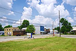
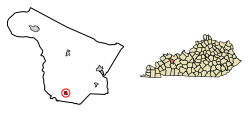
Sacramento is located in the southern part of McLean County. Its exact location is 37°24′59″N 87°16′4″W / 37.41639°N 87.26778°W. The city is mainly found where Kentucky Route 81/Kentucky Route 85 (Main Street) and Kentucky Route 254 (2nd Street) meet. This area is northeast of Madisonville.
Kentucky Route 81 and Kentucky Route 85 join together in the northeast part of town. They separate just south of the city.
- KY 81 goes north about 10 miles to Calhoun, which is the main town of the county. It also goes southeast the same distance to South Carrollton.
- KY 85 goes east about 8 miles to Island. It goes west about 15 miles to Madisonville.
- KY 254 also leads to Madisonville, but by a longer route of about 18 miles to the north.
The United States Census Bureau says that Sacramento covers a total area of about 0.43 square miles (1.12 square kilometers). All of this area is land.
People of Sacramento
| Historical population | |||
|---|---|---|---|
| Census | Pop. | %± | |
| 1860 | 373 | — | |
| 1870 | 195 | −47.7% | |
| 1880 | 172 | −11.8% | |
| 1890 | 297 | 72.7% | |
| 1900 | 434 | 46.1% | |
| 1910 | 438 | 0.9% | |
| 1920 | 410 | −6.4% | |
| 1930 | 327 | −20.2% | |
| 1940 | 379 | 15.9% | |
| 1950 | 378 | −0.3% | |
| 1960 | 429 | 13.5% | |
| 1970 | 437 | 1.9% | |
| 1980 | 538 | 23.1% | |
| 1990 | 563 | 4.6% | |
| 2000 | 517 | −8.2% | |
| 2010 | 468 | −9.5% | |
| 2020 | 429 | −8.3% | |
| U.S. Decennial Census | |||
In the year 2000, there were 517 people living in Sacramento. These people lived in 219 homes, and 150 of these were families. The city had about 1,230 people per square mile.
About 22% of the people were under 18 years old. About 15% were 65 years or older. The average age in the city was 36 years. For every 100 females, there were about 96 males.
The average income for a family in the city was about $27,344 per year. About 22% of the people in Sacramento lived below the poverty line. This included about 26% of those under 18 and 22% of those 65 or older.
See also
 In Spanish: Sacramento (Kentucky) para niños
 | Jewel Prestage |
 | Ella Baker |
 | Fannie Lou Hamer |

