South Carrollton, Kentucky facts for kids
Quick facts for kids
South Carrollton, Kentucky
|
|
|---|---|

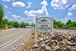
Welcome sign along US 431
|
|

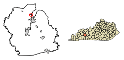
Location in Muhlenberg County, Kentucky
|
|
| Country | United States |
| State | Kentucky |
| County | Muhlenberg |
| Area | |
| • Total | 0.25 sq mi (0.66 km2) |
| • Land | 0.25 sq mi (0.65 km2) |
| • Water | 0.00 sq mi (0.00 km2) |
| Elevation | 449 ft (137 m) |
| Population
(2020)
|
|
| • Total | 141 |
| • Density | 557.31/sq mi (215.39/km2) |
| Time zone | UTC-6 (Central (CST)) |
| • Summer (DST) | UTC-5 (CDT) |
| ZIP code |
42374
|
| Area code(s) | 270 |
| FIPS code | 21-71814 |
| GNIS feature ID | 0503897 |
South Carrollton is a small city in Muhlenberg County, Kentucky, United States. In 2020, about 141 people lived there. This was a bit less than the 184 people who lived there in 2010.
The city was first started in 1838 and was called "Randolph Old Farm." Later, an early settler changed the name to "Carroll" to honor his son. They added "South" to the name to make sure people didn't confuse it with another city called Carrollton.
Where is South Carrollton?
South Carrollton is located in the northern part of Muhlenberg County. It sits right on the western side of the Green River. The city is just north of Central City.
Important roads run through South Carrollton. U.S. Route 431 connects the city to Central City in the south and Island in the north. Another road, Kentucky Route 81, crosses US 431 in South Carrollton. This road links the city to places like Bremen and Sacramento to the northwest.
The city covers a total area of about 0.65 square kilometers (0.25 square miles). Only a tiny part of this area is water.
How Many People Live Here?
The number of people living in South Carrollton has changed over many years. Here's a quick look at the population counts from different times:
| Historical population | |||
|---|---|---|---|
| Census | Pop. | %± | |
| 1870 | 240 | — | |
| 1880 | 493 | 105.4% | |
| 1890 | 525 | 6.5% | |
| 1900 | 452 | −13.9% | |
| 1910 | 365 | −19.2% | |
| 1920 | 328 | −10.1% | |
| 1930 | 334 | 1.8% | |
| 1940 | 296 | −11.4% | |
| 1950 | 289 | −2.4% | |
| 1960 | 234 | −19.0% | |
| 1970 | 218 | −6.8% | |
| 1980 | 262 | 20.2% | |
| 1990 | 202 | −22.9% | |
| 2000 | 184 | −8.9% | |
| 2010 | 184 | 0.0% | |
| 2020 | 141 | −23.4% | |
| U.S. Decennial Census | |||
In the year 2000, there were 184 people living in South Carrollton. These people lived in 70 different homes, and 53 of those were families. Most of the people living there were White (about 97%).
About 36% of the homes had children under 18 living in them. Most homes (60%) were married couples living together. About 17% of all homes were single people living alone. The average home had about 2.6 people.
The people in South Carrollton had different ages. About 23% were under 18 years old. The largest group, about 32%, was between 25 and 44 years old. About 14% of the people were 65 or older. The average age in the city was 39 years old.
The average income for a household in 2000 was $27,500. For families, the average income was $38,750. A small number of families (about 3.7%) and people (about 14%) lived below the poverty line. This included some children and some older adults.
See also
 In Spanish: South Carrollton (Kentucky) para niños
 | Stephanie Wilson |
 | Charles Bolden |
 | Ronald McNair |
 | Frederick D. Gregory |

