Daviess County, Kentucky facts for kids
Quick facts for kids
Daviess County
|
|||
|---|---|---|---|

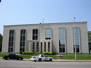
Daviess County courthouse in Owensboro
|
|||
|
|||

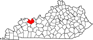
Location within the U.S. state of Kentucky
|
|||
 Kentucky's location within the U.S. |
|||
| Country | |||
| State | |||
| Founded | January 14, 1815 | ||
| Named for | Joseph Hamilton Daveiss | ||
| Seat | Owensboro | ||
| Largest city | Owensboro | ||
| Area | |||
| • Total | 477 sq mi (1,240 km2) | ||
| • Land | 458 sq mi (1,190 km2) | ||
| • Water | 18 sq mi (50 km2) 3.8%% | ||
| Population
(2020)
|
|||
| • Total | 103,312 | ||
| • Estimate
(2023)
|
103,458 |
||
| • Density | 216.59/sq mi (83.62/km2) | ||
| Time zone | UTC−6 (Central) | ||
| • Summer (DST) | UTC−5 (CDT) | ||
| Congressional district | 2nd | ||
Daviess County (pronounced "Davis") is a county located in Kentucky. In 2020, about 103,312 people lived here. The main town and government center is Owensboro. Daviess County was created on January 14, 1815. It was formed from a part of Ohio County.
Daviess County is part of the Owensboro area. It shares its name with another Daviess County in Indiana. Both counties are in the area where Illinois, Indiana, and Kentucky meet.
Contents
History of Daviess County
Daviess County was officially started in 1815. It is named after Major Joseph Hamilton Daveiss. He was a lawyer for the United States. There was a small mistake in the spelling of his name when the county was formed, and it was never changed.
The county's borders have changed a few times. In 1829, some land was used to create Hancock County. Later, in 1830, a small area around Whitesville was added. In 1854, some land was given to McLean County. Finally, in 1860, about 44 square miles (114 square kilometers) were added from Henderson County.
During the American Civil War in January 1865, the courthouse burned down. Luckily, the county's important records were saved. They had been moved to a church for safekeeping.
Geography of Daviess County
Daviess County covers a total area of about 477 square miles (1,235 square kilometers). Most of this area, about 458 square miles (1,186 square kilometers), is land. The remaining 18 square miles (47 square kilometers) is water, which is about 3.8% of the total area.
The northern part of the county, near the Ohio River, is mostly flat. It has a few gentle hills scattered around. The southern part of the county has more rolling hills mixed with flat valleys. In the past, people mined coal in the southern areas, especially in the hills along Panther Creek.
Neighboring Counties
Daviess County shares its borders with several other counties:
- Warrick County, Indiana (to the northwest)
- Spencer County, Indiana (to the northeast)
- Hancock County (to the east)
- Ohio County (to the southeast)
- McLean County (to the southwest)
- Henderson County (to the west)
Population of Daviess County
| Historical population | |||
|---|---|---|---|
| Census | Pop. | %± | |
| 1820 | 3,876 | — | |
| 1830 | 5,209 | 34.4% | |
| 1840 | 8,331 | 59.9% | |
| 1850 | 12,362 | 48.4% | |
| 1860 | 15,549 | 25.8% | |
| 1870 | 20,714 | 33.2% | |
| 1880 | 27,730 | 33.9% | |
| 1890 | 33,120 | 19.4% | |
| 1900 | 38,667 | 16.7% | |
| 1910 | 41,020 | 6.1% | |
| 1920 | 40,733 | −0.7% | |
| 1930 | 43,779 | 7.5% | |
| 1940 | 52,335 | 19.5% | |
| 1950 | 57,241 | 9.4% | |
| 1960 | 70,588 | 23.3% | |
| 1970 | 79,486 | 12.6% | |
| 1980 | 85,949 | 8.1% | |
| 1990 | 87,189 | 1.4% | |
| 2000 | 91,545 | 5.0% | |
| 2010 | 96,656 | 5.6% | |
| 2020 | 103,312 | 6.9% | |
| 2023 (est.) | 103,458 | 7.0% | |
| U.S. Decennial Census 1790–1960 1900–1990 1990–2000 2010–2020 |
|||
In 2010, there were 96,656 people living in Daviess County. There were 36,033 homes and 24,826 families. The county had about 198 people per square mile (76 per square kilometer).
Most people in the county were White (93.69%). About 4.35% were Black or African American. Other groups included Native American, Asian, and people of two or more races. About 0.92% of the population was Hispanic or Latino.
About 25.80% of the people were under 18 years old. About 13.80% were 65 years or older. The average age in the county was 37 years.
Economy of Daviess County
Daviess County has a history of important industries.
Distilling History
Daviess County has been known for making distilled spirits for a long time. This includes Kentucky bourbon. Walter McFarland started making whiskey and peach brandy around 1804. He had a 200-acre (0.81 square kilometer) estate south of Panther Creek. Cornelius Westerfield also began making corn whiskey in the early 1800s.
By the 1880s, 18 large distilleries were working in Daviess County at the same time. Today, only three remain. One of them, the former Glenmore Distillery Company, started in 1869. Another, the Green River Distillery, began in 1885. It closed during Prohibition but was later reopened and renamed. In 2020, it was renamed Green River Distilling Co., bringing back its original name.
Coal Mining History
The southwestern part of Daviess County, near Panther Creek, had a lot of coal mining. This continued from the 1960s until the early 1990s. After 1998, some large areas of mined land were left untouched.
The state government worked to clean up these areas. One large area was 42 acres (170,000 square meters) that used to be part of the Green Coal Company. This company was important for mining in Daviess County.
Cleanup work started in November 1999 and finished in April 2000. The land was made safe and stable again. It is now considered good land for farming. The project cost about $127,538.82.
Communities in Daviess County
Daviess County has several towns and communities.
Cities
- Owensboro (This is the county seat, where the main government offices are)
- Whitesville
Census-Designated Places
These are areas that are like towns but are not officially incorporated as cities.
- Curdsville
- Knottsville
- Maceo
- Masonville
- Moseleyville
- Panther
- Pleasant Ridge (partially in Ohio County)
- Utica
Other Unincorporated Communities
These are smaller communities that are not officially cities or census-designated places.
- Andersonville
- Birk City
- Boston
- Browns Valley
- Delaware
- Dermont
- Doyle
- Ensor
- Gatewood
- Griffith
- Habit
- Handyville
- Livia (partially in McLean County)
- Maxwell
- Newman
- Oak Ridge
- Oklahoma
- Pettit
- Philpot
- Red Hill
- Rome
- Saint Joseph
- Scythia
- Sorgho
- Spice Knob
- Stanley
- Sutherland
- Thruston
- Tuck
- West Louisville
- Yelvington
See also
 In Spanish: Condado de Daviess (Kentucky) para niños
 | Aurelia Browder |
 | Nannie Helen Burroughs |
 | Michelle Alexander |


