
Hardin County, Kentucky facts for kids
Quick facts for kids
Hardin County
|
|||
|---|---|---|---|

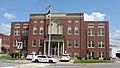
Hardin County courthouse in Elizabethtown
|
|||
|
|||

Location within the U.S. state of Kentucky
|
|||
 Kentucky's location within the U.S. |
|||
| Country | |||
| State | |||
| Founded | 1792 | ||
| Named for | John Hardin | ||
| Seat | Elizabethtown | ||
| Largest city | Elizabethtown | ||
| Area | |||
| • Total | 630 sq mi (1,600 km2) | ||
| • Land | 623 sq mi (1,610 km2) | ||
| • Water | 6.9 sq mi (18 km2) 1.1%% | ||
| Population
(2020)
|
|||
| • Total | 110,702 | ||
| • Estimate
(2023)
|
112,273 |
||
| • Density | 175.7/sq mi (67.8/km2) | ||
| Time zone | UTC−5 (Eastern) | ||
| • Summer (DST) | UTC−4 (EDT) | ||
| Congressional district | 2nd | ||


Hardin County is a place in the central part of Kentucky, a state in the United States. The main town, or county seat, is Elizabethtown. The county was started in 1792.
Hardin County is part of a larger area that includes Elizabethtown and Fort Knox. It's also connected to the bigger Louisville area. In 2020, about 110,702 people lived here.
Hardin County is famous for being the birthplace of Abraham Lincoln, who later became a U.S. president. However, that specific spot is now in a nearby county called LaRue County.
Contents
History of Hardin County
Hardin County was created in 1792. Land was taken from Nelson County to form it. It was the 15th county ever formed in Kentucky.
The county is named after John Hardin. He was a brave officer in the Continental Army during the American Revolution, which was the war for America's independence. His brother, William Hardin, founded a town called Hardinsburg.
The county's old records were lost twice because of fires at the courthouse, once in 1864 and again in 1932. The current courthouse was built in 1934.
Geography of Hardin County
Hardin County covers about 630 square miles. Most of this area is land (623 square miles), and a small part (about 6.9 square miles) is water. This makes it the fourth-largest county in Kentucky by size.
Counties Nearby
Hardin County shares its borders with nine other counties. This is more than any other county in Kentucky!
- Louisville-Jefferson County (to the northeast)
- Bullitt County (to the northeast)
- Nelson County (to the east)
- LaRue County (to the southeast)
- Hart County (to the south, also a time zone border)
- Grayson County (to the southwest, also a time zone border)
- Breckinridge County (to the west, also a time zone border)
- Meade County (to the northwest)
- Harrison County, Indiana (to the north)
People of Hardin County
| Historical population | |||
|---|---|---|---|
| Census | Pop. | %± | |
| 1800 | 3,653 | — | |
| 1810 | 7,531 | 106.2% | |
| 1820 | 10,498 | 39.4% | |
| 1830 | 12,849 | 22.4% | |
| 1840 | 16,357 | 27.3% | |
| 1850 | 14,525 | −11.2% | |
| 1860 | 15,189 | 4.6% | |
| 1870 | 15,705 | 3.4% | |
| 1880 | 22,564 | 43.7% | |
| 1890 | 21,304 | −5.6% | |
| 1900 | 22,937 | 7.7% | |
| 1910 | 22,696 | −1.1% | |
| 1920 | 24,287 | 7.0% | |
| 1930 | 20,913 | −13.9% | |
| 1940 | 29,108 | 39.2% | |
| 1950 | 50,312 | 72.8% | |
| 1960 | 67,789 | 34.7% | |
| 1970 | 78,421 | 15.7% | |
| 1980 | 88,917 | 13.4% | |
| 1990 | 89,240 | 0.4% | |
| 2000 | 94,174 | 5.5% | |
| 2010 | 105,543 | 12.1% | |
| 2020 | 110,702 | 4.9% | |
| 2023 (est.) | 112,273 | 6.4% | |
| U.S. Decennial Census 1790–1960 1900–1990 1990–2000 2010–2020 |
|||
In 2010, there were 105,543 people living in Hardin County. The population density was about 167.5 people per square mile. The county has grown steadily over the years.
The median age of people in Hardin County was 35 years old. This means half the people were younger than 35, and half were older.
Economy of Hardin County

The economy of Hardin County is greatly helped by Fort Knox, a large military base nearby. Many jobs in the county are connected to the base.
A huge building called the Army Human Resource Center was built at Fort Knox. It's a very large office complex. Many new civilian workers, who handle human resources and computer tasks, moved to the area to work there.
Because of changes at Fort Knox in 2005, thousands of soldiers and their families, along with civilian workers, moved to Hardin County. This brought a lot of new money and building projects to the area.
The governor of Kentucky even created a special group to help Hardin County and its neighbors get ready for these changes. They worked on things like transportation, new businesses, schools, and water systems.
Hardin County has special rules about selling alcohol. It's known as a "moist county" and a "limited dry county." This means that while the county as a whole might have some restrictions, certain cities within it, like Elizabethtown, Radcliff, and Vine Grove, have voted to allow alcohol sales in stores. Some restaurants in places like West Point can also sell alcohol if they meet certain rules.
Education in Hardin County
Schools for Kids (K-12)
There are two main public school systems in Hardin County:
- The Hardin County Schools serve most students in the county. They have many elementary, middle, and high schools. A smaller school district, West Point Independent School District, joined the Hardin County district in 2020.
- The Elizabethtown Independent Schools serve students mostly within the city of Elizabethtown. They have elementary schools, a middle school, and Elizabethtown High School.
Students who live on the Fort Knox military base go to schools run by the Department of Defense Education Activity (DoDEA). These schools are specifically for children of military families. Fort Knox has elementary, intermediate, middle, and high schools on the base. A new, modern Fort Knox High School was completed in 2008.
There are also five private schools in Hardin County: St. James Catholic School, Gloria Dei Lutheran School, Elizabethtown Christian Academy, North Hardin Christian School, and Hardin Christian Academy.
Colleges and Higher Education
Elizabethtown is home to Elizabethtown Community and Technical College. This college is part of the Kentucky Community and Technical College System and offers many different programs for students after high school.
- Elizabethtown Community and Technical College – Home Page
Communities in Hardin County
Cities
- Elizabethtown (the main town)
- Muldraugh (mostly in a nearby county)
- Radcliff
- Sonora
- Upton (partly in a nearby county)
- Vine Grove
- West Point
Census-designated places
These are areas that are like towns but are not officially incorporated as cities.
- Cecilia
- Fort Knox (a military base, partly in other counties)
- Rineyville
Unincorporated communities
These are smaller communities that are not part of any city or census-designated place.
- Big Spring (partly in other counties and time zones)
- Blue Ball
- Colesburg
- Dever Hollow
- Eastview
- Glendale
- Harcourt
- Howell Spring
- Hardin Springs
- Howe Valley
- Mill Creek
- New Fruit
- Nolin
- Old Stephensburg
- Quaker Valley
- Red Mills
- St. John
- Star Mills
- Stephensburg
- Summitt
- Tip Top
- Tunnel Hill
- Vertrees
- White Mills
- Youngers Creek
Images for kids
-
Hardin County courthouse in Elizabethtown
-

Flag of Hardin County, Kentucky
-
Seal of Hardin County, Kentucky
See also
 In Spanish: Condado de Hardin (Kentucky) para niños
