Upton, Kentucky facts for kids
Quick facts for kids
Upton, Kentucky
|
|
|---|---|

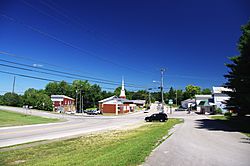
U.S. Route 31W in Upton
|
|

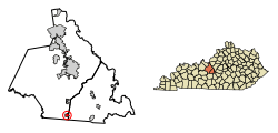
Location of Upton in Hardin County, Kentucky.
|
|
| Country | United States |
| State | Kentucky |
| Counties | Hardin, LaRue |
| Area | |
| • Total | 1.36 sq mi (3.53 km2) |
| • Land | 1.36 sq mi (3.52 km2) |
| • Water | 0.01 sq mi (0.01 km2) |
| Elevation | 748 ft (228 m) |
| Population
(2020)
|
|
| • Total | 704 |
| • Density | 518.41/sq mi (200.21/km2) |
| Time zone | UTC-5 (Eastern (EST)) |
| • Summer (DST) | UTC-4 (EDT) |
| ZIP code |
42784
|
| Area code(s) | 270 & 364 |
| FIPS code | 21-78672 |
| GNIS feature ID | 0505924 |
Upton is a small city in Kentucky, located in both Hardin and LaRue counties. It is a "home rule-class city," which means it has the power to manage its own local affairs. In 2020, about 704 people lived there. This was a small increase from 683 people in 2010. Upton is part of the larger Elizabethtown–Fort Knox area.
Contents
History of Upton
When Was Upton Founded?
Upton was first settled in 1841. It was originally called "Leesville." The city got its current name in 1856. It was named after George Washington Upton. He helped develop the area as an important stop for the L&N Railroad.
Upton During the Civil War
During the Civil War, Upton was a target for Confederate forces. A famous Confederate general, John Hunt Morgan, attacked the town. The L&N Railroad was very important for the Union army. It was a key route for moving supplies and troops between the North and South.
On December 26, 1862, Morgan's troops attacked Upton's train station and nearby bridges. The Union soldiers there were quickly defeated. Morgan then used the telegraph station in Upton. He gathered information about where Union troops were located. After that, Morgan left Upton to destroy more bridges. These bridges were at Bacon Creek in Bonnieville and on the Nolin River.
Geography of Upton
Where is Upton Located?
Upton is located where Hardin County and LaRue County meet. It is near the southeast corner of Hardin County and the southwest corner of LaRue County. The main road through the city is U.S. Route 31W. This road also follows the county line.
How to Get Around Upton
U.S. Route 31W is a two-lane highway. If you go north about 4 miles, you will reach Sonora. Going south about 6 miles will take you to Bonnieville. A lot of Upton is built around where US 31W crosses Kentucky Route 224. Route 224 goes west towards Leitchfield.
Interstate 65 runs along the eastern edge of Upton. You can get on or off I-65 at Exit 76. Traveling north on I-65 for about 17 miles leads to Elizabethtown. This is the main city in Hardin County. If you go south on I-65 for about 24 miles, you will reach Cave City.
Size of Upton
The United States Census Bureau reports that Upton covers a total area of about 1.36 square miles (3.5 square kilometers). Most of this area is land. Only a very small part, about 0.01 square miles (0.01 square kilometers), is water.
Population of Upton
How Many People Live in Upton?
| Historical population | |||
|---|---|---|---|
| Census | Pop. | %± | |
| 1900 | 125 | — | |
| 1910 | 141 | 12.8% | |
| 1920 | 369 | 161.7% | |
| 1930 | 402 | 8.9% | |
| 1940 | 369 | −8.2% | |
| 1950 | 383 | 3.8% | |
| 1960 | 547 | 42.8% | |
| 1970 | 552 | 0.9% | |
| 1980 | 731 | 32.4% | |
| 1990 | 719 | −1.6% | |
| 2000 | 654 | −9.0% | |
| 2010 | 683 | 4.4% | |
| 2020 | 704 | 3.1% | |
| U.S. Decennial Census | |||
According to the census from 2000, there were 654 people living in Upton. These people lived in 283 different homes. The population density was about 423 people per square mile.
Age Groups in Upton
The census data from 2000 also shows the different age groups in Upton:
- About 22% of the people were under 18 years old.
- About 8.3% were between 18 and 24 years old.
- About 27.1% were between 25 and 44 years old.
- About 24% were between 45 and 64 years old.
- About 18.7% were 65 years old or older.
The average age of people in Upton was 41 years.
See also
 In Spanish: Upton (Kentucky) para niños
 | Aaron Henry |
 | T. R. M. Howard |
 | Jesse Jackson |

