Bonnieville, Kentucky facts for kids
Quick facts for kids
Bonnieville, Kentucky
|
|
|---|---|

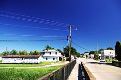
U.S. Route 31W in Bonnieville
|
|

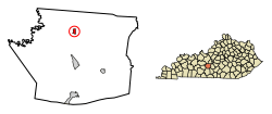
Location of Bonnieville in Hart County, Kentucky.
|
|
| Country | United States |
| State | Kentucky |
| County | Hart |
| Area | |
| • Total | 0.58 sq mi (1.49 km2) |
| • Land | 0.57 sq mi (1.49 km2) |
| • Water | 0.00 sq mi (0.00 km2) |
| Elevation | 650 ft (198 m) |
| Population
(2020)
|
|
| • Total | 269 |
| • Density | 467.83/sq mi (180.73/km2) |
| Time zone | UTC-6 (Central (CST)) |
| • Summer (DST) | UTC-5 (CDT) |
| ZIP Code |
42713
|
| Area codes | 270 & 364 |
| FIPS code | 21-08488 |
| GNIS feature ID | 0487671 |
Bonnieville is a small city in Hart County, Kentucky, in the United States. It is known as a home rule-class city, which means it has the power to govern itself in many ways. In 2020, the city had a population of 269 people.
Contents
History of Bonnieville
How Bonnieville Got Its Name
Bonnieville was founded in 1849. It was first called Bacon Creek. This name came from a stream that flows through the city.
There's a fun rumor about why the name changed to Bonnieville. People say it was because of the popular song "My Bonnie Lies over the Ocean".
Bonnieville During the Civil War
During the American Civil War, Bonnieville saw some action. On December 26, 1862, a group of Confederate soldiers arrived. They were led by John Hunt Morgan.
These soldiers came from Upton to a bridge over Bacon Creek in Bonnieville. There was a short fight with soldiers from the 2nd Michigan Volunteer Cavalry Regiment. The bridge was destroyed for the third time, and 23 soldiers were hurt. The railroad was closed for six weeks until it could be fixed. It reopened on February 1.
Geography of Bonnieville
Where is Bonnieville Located?
Bonnieville is located at 37°22′29″N 85°54′12″W.
The United States Census Bureau says the city covers about 0.6 square miles (1.49 square kilometers). All of this area is land.
Roads and Rivers in Bonnieville
U.S. Route 31W runs right through the middle of Bonnieville. Most of the city is built around where this highway meets Kentucky Route 728. You can also reach Bonnieville from Exit 71 on Interstate 65.
A part of the old Louisville and Nashville Railroad line, which is now CSX, also goes through the city. Bacon Creek, a small river that flows into the Nolin River, divides the city.
Population of Bonnieville
| Historical population | |||
|---|---|---|---|
| Census | Pop. | %± | |
| 1880 | 180 | — | |
| 1900 | 270 | — | |
| 1910 | 257 | −4.8% | |
| 1960 | 376 | — | |
| 1970 | 328 | −12.8% | |
| 1980 | 372 | 13.4% | |
| 1990 | 300 | −19.4% | |
| 2000 | 354 | 18.0% | |
| 2010 | 255 | −28.0% | |
| 2020 | 269 | 5.5% | |
| U.S. Decennial Census | |||
In 2000, there were 354 people living in Bonnieville. These people lived in 137 households, with 93 of them being families.
Age Groups in Bonnieville
The population in Bonnieville was spread out by age:
- About 30.8% of residents were under 18 years old.
- About 7.1% were between 18 and 24 years old.
- About 28.0% were between 25 and 44 years old.
- About 17.8% were between 45 and 64 years old.
- About 16.4% were 65 years old or older.
The average age in the city was 35 years.
Interesting Facts About Bonnieville
- In the early 1960s, the American Automobile Association (AAA) said Bonnieville was one of the worst "speed traps" in America. This means police there were very strict about catching drivers who went over the speed limit.
- There is a large Bamboo Research Station on the south side of town. It is believed to have the biggest collection of bamboo plants in all of Kentucky.
- Peppy Martin, who ran for governor of Kentucky as a Republican in 1999, lives in Bonnieville.
See also
 In Spanish: Bonnieville (Kentucky) para niños
 | Isaac Myers |
 | D. Hamilton Jackson |
 | A. Philip Randolph |

