Hartford, Kentucky facts for kids
Quick facts for kids
Hartford, Kentucky
|
|
|---|---|

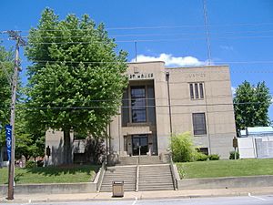
Ohio County Courthouse in Hartford
|
|

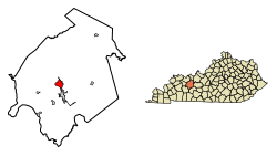
Location of Hartford in Ohio County, Kentucky.
|
|
| Country | United States |
| State | Kentucky |
| County | Ohio |
| Settled | Fort Hartford, 1790 |
| Incorporated | Hartford, 1808 |
| Named for | a deer crossing in the Rough River |
| Area | |
| • Total | 2.86 sq mi (7.40 km2) |
| • Land | 2.84 sq mi (7.35 km2) |
| • Water | 0.02 sq mi (0.05 km2) |
| Elevation | 417 ft (127 m) |
| Population
(2020)
|
|
| • Total | 2,668 |
| • Estimate
(2022)
|
2,636 |
| • Density | 940.43/sq mi (363.10/km2) |
| Time zone | UTC-6 (CST) |
| • Summer (DST) | UTC-5 (CDT) |
| ZIP Code |
42347
|
| Area code(s) | 270 & 364 |
| FIPS code | 21-35020 |
| GNIS feature ID | 0493841 |
| Website | https://hartfordky.org/ |
Hartford is a city in Ohio County, Kentucky, in the United States. It is the main town, or county seat, of Ohio County. In 2020, about 2,668 people lived there. A fun slogan for the town is "Home of 2,000 happy people and a few soreheads." The town's website explains that "soreheads" are actually people who care about their community and work to make it better.
Contents
History of Hartford
Hartford started as part of a very large piece of land. This land was given by Virginia to a person named Gabriel Madison. The area was first explored and mapped in 1782. People began to settle there before 1790.
Early Settlement and Fort Hartford
A small settlement called Fort Hartford (also known as Hartford Station) grew up. It was located where boats could no longer travel up the Rough River. The bridge over this river today is still called the Fort Hartford Bridge.
Early settlers faced attacks from Native American tribes. But in 1798, Hartford was chosen as the county seat for Ohio County, Kentucky. This happened because Mr. Madison gave some land for the new county buildings.
The town's post office opened in 1801. It was called Hartford Court House. In 1808, the state assembly officially made Hartford a city.
Building the First Fort
A settler named William Smithers wrote about building a fort in Hartford around 1782–83. Many people believe this was the first permanent settlement in Ohio County. It was likely a stockade (a fence of strong posts) and small log buildings. These were on a high bank above the Rough River.
The exact reason for the town's name is not fully known. Many think it comes from a place where deer (called "harts") crossed the Rough River. It might also be named after an early settler who ran a ferry there.
Civil War and Railroad Connection
During the American Civil War, Hartford's second courthouse was burned down. This happened on December 20, 1864. A Confederate general named Hylan B. Lyon was responsible.
Much later, in 1909, Hartford was connected to the L&N train network. This helped the town grow.
Downtown Hartford's Historic Buildings
The downtown area of Hartford has many historic buildings. These include the courthouse and other old shops. Most of these buildings are two stories tall. They show different styles from the late 1800s to the 1940s. Even though some parts have changed, the downtown area still looks very historic.
Economy and Jobs in Hartford
The Ohio County Economic Development Alliance (OCEDA) helps businesses in Hartford. They help new businesses start and existing ones grow. OCEDA provides information and support for companies.
There are 163 businesses in Hartford, employing almost 1,900 people. The main types of jobs in Hartford are in:
- Healthcare and Social Assistance
- Public Administration (government jobs)
- Retail (stores)
- Education
- Finance and Insurance
- Food and Beverage Stores
The OC Hub in downtown Hartford helps new businesses. It offers office space and meeting rooms.
Geography of Hartford
Hartford is located in the eastern part of Kentucky's western coal fields. It is one of the largest counties in Kentucky. The town covers about 2.6 square miles (7.4 square kilometers). It sits on the southeast bank of the Rough River.
The land in Hartford is gently rolling. The oldest part of town is in the west, along the Rough River. This area still shows the original town plan from the early 1800s.
Population and People
| Historical population | |||
|---|---|---|---|
| Census | Pop. | %± | |
| 1800 | 74 | — | |
| 1810 | 110 | 48.6% | |
| 1830 | 242 | — | |
| 1840 | 309 | 27.7% | |
| 1850 | 495 | 60.2% | |
| 1870 | 511 | — | |
| 1880 | 624 | 22.1% | |
| 1890 | 740 | 18.6% | |
| 1900 | 785 | 6.1% | |
| 1910 | 976 | 24.3% | |
| 1920 | 980 | 0.4% | |
| 1930 | 1,106 | 12.9% | |
| 1940 | 1,385 | 25.2% | |
| 1950 | 1,564 | 12.9% | |
| 1960 | 1,618 | 3.5% | |
| 1970 | 1,868 | 15.5% | |
| 1980 | 2,512 | 34.5% | |
| 1990 | 2,532 | 0.8% | |
| 2000 | 2,571 | 1.5% | |
| 2010 | 2,672 | 3.9% | |
| 2020 | 2,668 | −0.1% | |
| 2022 (est.) | 2,636 | −1.3% | |
| U.S. Decennial Census | |||
In 2000, there were 2,571 people living in Hartford. Most people were White (96.81%). There were also smaller groups of African American, Native American, and Asian people. About 0.86% of the population was Hispanic or Latino.
The average age in Hartford was 40 years old. About 22.1% of the population was under 18. About 20.8% of the population was 65 or older.
Famous People from Hartford
- Louise Alexander – a dancer.
- Allison J. Barnett (1892–1971) – a major general in the U.S. Army.
- Charles Courtney Curran (1861–1942) – an American painter. He was known for painting women in different settings.
- James and Virgil Earp – brothers of the famous Old West lawman Wyatt Earp.
- William Smeathers – a well-known frontiersman. He was one of the first settlers in the area now known as Owensboro.
Climate in Hartford
Hartford has a humid subtropical climate. This means it has hot, humid summers. The winters are generally mild to cool.
Education in Hartford
Hartford has a lending library called the Ohio County Public Library.
Public schools in Hartford are part of the Ohio County Public School district. Wayland Alexander Elementary School teaches students from preschool to 6th grade. In 2021, it had 633 students. The school mascot is a Mustang.
Many people in Hartford have gone to college. In 2021, about 21.7% of Hartford residents had a college degree. This includes associate, bachelor's, and graduate degrees.
| Education levels | Citizens |
|---|---|
| Graduated High School | 538 |
| Associate Degree | 229 |
| Bachelor's Degree | 227 |
| Graduate Degree | 128 |
Images for kids
See also
 In Spanish: Hartford (Kentucky) para niños
 | Chris Smalls |
 | Fred Hampton |
 | Ralph Abernathy |


