Derby, Indiana facts for kids
Quick facts for kids
Derby, Indiana
|
|
|---|---|

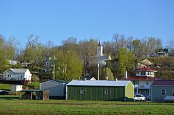
Overview from Mulzer Park
|
|
| Country | United States |
| State | Indiana |
| County | Perry |
| Township | Union |
| Elevation | 453 ft (138 m) |
| Time zone | UTC-6 (Central (CST)) |
| • Summer (DST) | UTC-5 (CDT) |
| ZIP code |
47525
|
| Area code(s) | 812, 930 |
| GNIS feature ID | 450842 |
Derby is a small community in Indiana, located right next to the Ohio River. It's in Perry County, specifically in Union Township. You can find Derby where two main roads, State Road 66 and State Road 70, meet. It's also close to Tell City, which is the main town of Perry County. Even though Derby isn't an official city, it has its own post office with the ZIP code 47525.
The Story of Derby
Derby was officially planned out and mapped in 1835. The community got its name from a place called Derby in Ireland. A post office has been open in Derby since 1852, helping people send and receive mail for a very long time.
Schools in Derby
Students in Union Township, where Derby is located, attend schools that are part of the Perry Central Community School Corporation.
Years ago, Derby had its own high school. The school colors were black and gold, and their sports teams were called the Warriors. Later, this high school joined with other schools to form Perry Central High School.
 | Tommie Smith |
 | Simone Manuel |
 | Shani Davis |
 | Simone Biles |
 | Alice Coachman |


