Williams, Lawrence County, Indiana facts for kids
Quick facts for kids
Williams, Indiana
|
|
|---|---|

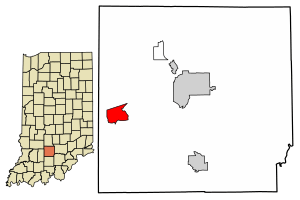
Location in Lawrence County, Indiana
|
|
| Country | United States |
| State | Indiana |
| County | Lawrence |
| Township | Spice Valley |
| Area | |
| • Total | 3.58 sq mi (9.27 km2) |
| • Land | 3.58 sq mi (9.26 km2) |
| • Water | 0.00 sq mi (0.01 km2) |
| Elevation | 538 ft (164 m) |
| Population
(2020)
|
|
| • Total | 229 |
| • Density | 64.06/sq mi (24.73/km2) |
| ZIP code |
47470
|
| FIPS code | 18-84338 |
| GNIS feature ID | 2583476 |
Williams is a small community located in Lawrence County, Indiana, in the United States. It's known as a census-designated place, which means it's an area identified by the government for statistics, but it's not officially a town or city. In 2010, about 286 people lived here.
Williams is right next to the East Fork of the White River. It's also home to the Williams Dam, a special structure that used to create electricity. This electricity powered many stone businesses in nearby places like Bedford and Bloomington.
Contents
A Look Back: Williams' History
The Williams community has an interesting past. A post office was first set up here in 1876. The town itself was officially planned out in 1889.
Building the Williams Dam
One of the most important parts of Williams' history is the dam. The Williams Dam was built on the East Fork of the White River between 1910 and 1911. It finally started working in 1913. For almost 40 years, this dam provided electricity to stone companies in the area.
Changes to the Dam
However, the dam stopped producing electricity in the 1950s. About 60 years later, a company from Boston called Free Flow Power Corp. thought about restarting the dam. They wanted to use it to create clean, renewable energy again. They planned to spend over $12 million to add new equipment. But, this plan was eventually stopped in 2018.
Where is Williams Located?
Williams is in the western part of Lawrence County. It's in the northern section of Spice Valley Township. The main part of Williams is along Indiana State Road 450, just north of the White River.
Size and Neighbors
The area of Williams includes the town center and some rural land around it. It stretches east to Crooked Creek and west to Dillman Road. The total area is about 3.6 square miles (9.3 km2), with a very small amount of that being water. From Williams, you can drive about 11 miles (18 km) southwest to Bedford, which is the main town of Lawrence County. It's also about 22 miles (35 km) northeast of Loogootee.
The Famous Williams Bridge
The Williams Bridge is a very special landmark near the community. It's also known as the Lawrence County Bridge. This bridge used to be the longest double-span covered bridge in Indiana that cars could still drive on!
Bridge Details
The Williams Bridge crosses the East Fork of the White River. It was built in 1884 by Joseph J. Daniels. The bridge is about 373 feet (114 m) long, or 402 feet (123 m) if you include the parts that stick out at each end. It's named after the nearby town, which was named for an early settler named Isaac Williams.
Historical Importance
Even though there isn't a historical sign, the Williams Bridge was added to the National Register of Historic Places in 1981. This means it's recognized as an important historical site.
Current Status
The bridge was fixed up in 2013. However, it has been closed to cars since around September 2010. The Medora Bridge in Jackson County is now the longest covered bridge in Indiana at 434 feet (132 m), but it's only open to people walking, not cars.
How Many People Live in Williams?
The population of Williams changes over time. In 2010, about 286 people lived there. By 2020, the population was 229.
| Historical population | |||
|---|---|---|---|
| Census | Pop. | %± | |
| 2010 | 286 | — | |
| 2020 | 229 | −19.9% | |
| U.S. Decennial Census | |||
See also
 In Spanish: Williams (Indiana) para niños
 | Bayard Rustin |
 | Jeannette Carter |
 | Jeremiah A. Brown |

