Scott County, Indiana facts for kids
Quick facts for kids
Scott County
|
|
|---|---|

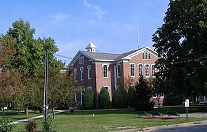
Scott County Courthouse in Scottsburg, Indiana
|
|

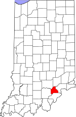
Location within the U.S. state of Indiana
|
|
 Indiana's location within the U.S. |
|
| Country | |
| State | |
| Founded | 1820 |
| Named for | Charles Scott |
| Seat | Scottsburg |
| Largest city | Scottsburg |
| Area | |
| • Total | 192.75 sq mi (499.2 km2) |
| • Land | 190.40 sq mi (493.1 km2) |
| • Water | 2.35 sq mi (6.1 km2) 1.22%% |
| Population
(2020)
|
|
| • Total | 24,384 |
| • Estimate
(2023)
|
24,657 |
| • Density | 126.506/sq mi (48.8442/km2) |
| Time zone | UTC−5 (Eastern) |
| • Summer (DST) | UTC−4 (EDT) |
| Congressional district | 9th |
| Indiana county number 72 | |
Scott County is a place in the state of Indiana, USA. It is a type of local government area called a county. In 2020, about 24,384 people lived here. The main town and government center of the county is Scottsburg.
Contents
A Look Back: Scott County's History
Scott County was created in 1820. It was formed from parts of other nearby counties like Clark and Jackson. The county was named after General Charles Scott. He was the Governor of Kentucky from 1808 to 1812. A lot of the county's water comes from Hardy Lake.
Exploring Scott County's Geography
Scott County covers a total area of about 192.75 square miles. Most of this area, about 190.40 square miles, is land. The rest, about 2.35 square miles, is water.
Main Cities and Towns
Scott County has a few important towns:
Smaller Communities and Unincorporated Towns
There are also smaller places that are not officially cities or towns:
Local Government Areas: Townships
The county is divided into smaller areas called townships:
- Finley
- Jennings
- Johnson
- Lexington
- Vienna
Neighboring Counties
Scott County shares its borders with several other counties:
- Jennings County to the north
- Jefferson County to the east
- Clark County to the south
- Washington County to the west
- Jackson County to the northwest
Important Roads and Highways
Many major roads pass through Scott County, helping people travel around:
 Interstate 65
 U.S. Route 31
 State Road 3
 State Road 56
 State Road 160
 State Road 203
 State Road 256
 State Road 356
 State Road 362
Understanding Scott County's Climate
| Weather chart for Scottsburg, Indiana | |||||||||||||||||||||||||||||||||||||||||||||||
|---|---|---|---|---|---|---|---|---|---|---|---|---|---|---|---|---|---|---|---|---|---|---|---|---|---|---|---|---|---|---|---|---|---|---|---|---|---|---|---|---|---|---|---|---|---|---|---|
| J | F | M | A | M | J | J | A | S | O | N | D | ||||||||||||||||||||||||||||||||||||
|
3.1
38
20
|
2.8
44
23
|
4.1
55
32
|
4.4
66
42
|
4.8
75
52
|
4.2
84
61
|
4.4
87
65
|
4.4
86
63
|
3.1
80
55
|
2.9
68
42
|
3.7
55
34
|
3.4
43
25
|
||||||||||||||||||||||||||||||||||||
| temperatures in °F precipitation totals in inches source: The Weather Channel |
|||||||||||||||||||||||||||||||||||||||||||||||
|
Metric conversion
|
|||||||||||||||||||||||||||||||||||||||||||||||
In Scottsburg, the average temperatures change throughout the year. January is usually the coldest month, with lows around 20°F. July is the warmest, with highs around 87°F. The coldest temperature ever recorded was -32°F in January 1977. The hottest was 109°F in July 1930.
The amount of rain and snow also changes. February usually has the least precipitation, about 2.84 inches. May often has the most, with about 4.75 inches.
Who Lives in Scott County? Demographics
| Historical population | |||
|---|---|---|---|
| Census | Pop. | %± | |
| 1820 | 2,334 | — | |
| 1830 | 3,092 | 32.5% | |
| 1840 | 4,242 | 37.2% | |
| 1850 | 5,885 | 38.7% | |
| 1860 | 7,303 | 24.1% | |
| 1870 | 7,873 | 7.8% | |
| 1880 | 8,343 | 6.0% | |
| 1890 | 7,833 | −6.1% | |
| 1900 | 8,307 | 6.1% | |
| 1910 | 8,323 | 0.2% | |
| 1920 | 7,424 | −10.8% | |
| 1930 | 6,664 | −10.2% | |
| 1940 | 8,978 | 34.7% | |
| 1950 | 11,519 | 28.3% | |
| 1960 | 14,463 | 25.6% | |
| 1970 | 17,144 | 18.5% | |
| 1980 | 20,422 | 19.1% | |
| 1990 | 20,991 | 2.8% | |
| 2000 | 22,960 | 9.4% | |
| 2010 | 24,181 | 5.3% | |
| 2020 | 24,384 | 0.8% | |
| 2023 (est.) | 24,657 | 2.0% | |
| U.S. Decennial Census 1790-1960 1900-1990 1990-2000 2010 |
|||
According to the 2010 United States Census, 24,181 people lived in Scott County. There were 9,397 homes and 6,648 families. The population density was about 127 people per square mile.
About 34.1% of homes had children under 18 living there. Most homes, 51.4%, were married couples. The average home had 2.54 people. The average family had 2.97 people. The average age of people in the county was 39.3 years old.
Public Health Efforts in 2015
In 2015, Scott County faced a serious public health challenge. The state of Indiana declared a public health emergency to help the community. To address the situation, the governor of Indiana, Mike Pence, signed an order. This order allowed a special program to open in the county. This program helped provide important health resources to people. It was the first program of its kind in Indiana. A local doctor, Dr. William Cooke, played a key role in helping the community during this time. While the program was successful, county officials later voted to end it in June 2021.
See also
 In Spanish: Condado de Scott (Indiana) para niños
 | Delilah Pierce |
 | Gordon Parks |
 | Augusta Savage |
 | Charles Ethan Porter |

