
Lyndon, Kentucky facts for kids
Quick facts for kids
Lyndon, Kentucky
|
|
|---|---|

Lyndon, Kentucky
|
|

Location of Lyndon in Jefferson County, Kentucky
|
|

Lyndon, Kentucky
Location in Kentucky

Lyndon, Kentucky
Location in the United States
|
|
| Country | United States |
| State | Kentucky |
| County | Jefferson |
| Area | |
| • Total | 3.63 sq mi (9.41 km2) |
| • Land | 3.60 sq mi (9.33 km2) |
| • Water | 0.03 sq mi (0.08 km2) |
| Elevation | 620 ft (190 m) |
| Population
(2020)
|
|
| • Total | 11,008 |
| • Density | 3,056.93/sq mi (1,180.28/km2) |
| Time zone | UTC-5 (Eastern (EST)) |
| • Summer (DST) | UTC-4 (EDT) |
| ZIP codes |
40222, 40241-40242, 40252
|
| Area code(s) | 502 |
| FIPS code | 21-48558 |
| GNIS feature ID | 2404980 |
Lyndon is a city in Jefferson County, Kentucky, United States. It is known as a "home rule-class city." This means it has its own local government and can make many of its own rules. In 2010, about 11,002 people lived there. By 2020, the population had grown slightly to 11,008.
Lyndon became an official city on May 10, 1965. In 2003, it joined the new Louisville Metro government. Even though it's part of Louisville Metro, Lyndon still acts as an independent city. It has its own mayor and emergency services. People living in Lyndon can vote for the mayor of Louisville and other city council members.
Contents
History of Lyndon
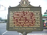
The area where Lyndon is located has a long history. Oxmoor Farm, a famous old home, is here. It belonged to Alexander Scott Bullitt, who helped write Kentucky's first constitution.
After 1865, a railroad company called the L&N offered to build a train station in the area. A local landowner, Alvin Wood, paid for the station and gave the land for the tracks. The Lyndon train station opened in 1871. No one is completely sure how the town got its name. Some think it's from Linn's Station, while others believe it's named after explorer William Linn.
Other important places were built in Lyndon. The Bellevoir-Ormsby Village was built in 1867. The Kentucky Military Institute moved to the town in 1896. Central State Hospital, a large medical facility, is also located near Lyndon.
In 1963, Lyndon's post office became part of the Louisville postal system. Soon after, Lyndon officially became a city. This was done to prevent the nearby city of St. Matthews from taking over Lyndon's land.
Geography of Lyndon
Lyndon is located in the northeastern part of Jefferson County. It is about 9 miles (14 km) east of downtown Louisville. Other towns close to Lyndon include Graymoor-Devondale to the northwest and St. Matthews to the southwest. Hurstbourne is to the south, and Anchorage is to the east. A major road, U.S. Route 60 (Shelbyville Road), forms part of Lyndon's southern border.
The United States Census Bureau says that Lyndon covers a total area of about 3.63 square miles (9.4 square kilometers). A very small part of this area, about 0.03 square miles (0.08 square kilometers), is water.
Population and People
At the 2010 census, there were 11,002 people living in Lyndon. There were 5,374 households and 2,585 families. Most of the people (80.4%) were White. About 11.4% were African American, and 2.1% were Asian. People from other backgrounds made up smaller parts of the population. About 6.9% of the population was Hispanic or Latino.
| Historical population | |||
|---|---|---|---|
| Census | Pop. | %± | |
| 1970 | 460 | — | |
| 1980 | 1,553 | 237.6% | |
| 1990 | 8,037 | 417.5% | |
| 2000 | 9,369 | 16.6% | |
| 2010 | 11,002 | 17.4% | |
| 2020 | 11,008 | 0.1% | |
| U.S. Decennial Census | |||
Out of all the households, 22.9% had children under 18 living with them. About 32.9% were married couples. Many households (51.9%) were not families. The average household had about 2 people, and the average family had almost 3 people.
About 20% of the people in Lyndon were under 18 years old. The median age, which is the middle age of all the people, was 33 years. This means half the population was younger than 33 and half was older.
In 2017, the average income for a household was about $52,431 per year. For families, the average income was higher, around $71,025. The income per person was about $34,183. A small number of families (2.7%) and people (6.8%) lived below the poverty line. This means their income was below a certain level set by the government.
According to the 2022 US census, the population is 10,928. This is a small decrease from the 2020 census.
Robsion Park

Robsion Park is a 17-acre park located in the middle of Lyndon. It is between Lake Avenue and LaGrange Road. The park has many things for people to enjoy. You can find benches, picnic tables, and a covered pavilion. There are two playgrounds, one for younger kids and one for older kids. The park also has a new splash pad, which is a fun water play area. For those who like to walk or run, there is a 3/8-mile walking trail. The park is named after John M. Robsion Jr., who gave the land for the park in 1985.
Economy and Businesses
Lyndon is home to several important businesses and shopping areas.
- Kroger's Mid-South offices are located in Lyndon. Kroger is a very large grocery store chain.
- UPS Air Group, a part of the major shipping company UPS, also has operations here.
- Westport Village is a popular shopping complex in Lyndon.
Gallery
-
Lyndon historical marker
-
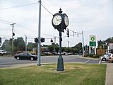
Lyndon Clock
-
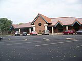
Lyndon Post Office
-
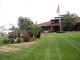
Lyndon City Hall


See also
 In Spanish: Lyndon (Kentucky) para niños
