Alum Creek (Ohio) facts for kids
Quick facts for kids Alum Creek |
|
|---|---|

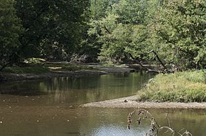
The confluence of the Alum Creek and Big Walnut Creek. Alum Creek is in the center of the image and Big Walnut Creek is coming from the right.
|
|
| Country | United States of America |
| Physical characteristics | |
| Main source | 40°32′00″N 082°49′02″W / 40.53333°N 82.81722°W 1 mile (1.6 km) South-West of Mount Gilead 1,160 ft (350 m) |
| River mouth | 39°52′52″N 082°54′27″W / 39.88111°N 82.90750°W Big Walnut Creek near Obetz, Ohio 718 ft (219 m) |
| Basin features | |
| Basin size | 199 sq mi (520 km2) |
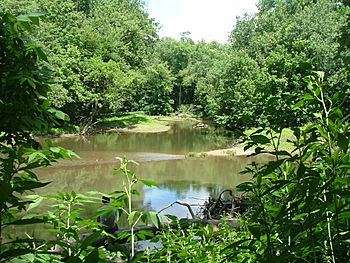
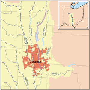
Alum Creek is a 58-mile (93 km) long creek in central Ohio. It flows from north to south. The creek starts in Morrow County. Then it flows through Delaware County. Finally, it reaches Franklin County. Here, it joins Big Walnut Creek. Big Walnut Creek then flows into the Scioto River. Alum Creek provides drinking water for the city of Westerville, Ohio.
Contents
History of Alum Creek
The area around Alum Creek has a long history. Over 2,000 years ago, the Adena culture lived here. These people are known as Mound builders. They built seven mounds along Alum Creek. Later, the Lenape (also called Delaware) Indian tribe settled near the creek.
One of the first European settlers was Colonel Moses Byxbe. He built his home on Alum Creek in 1805. Colonel Byxbe owned a large amount of land, about 38,000 acres (150 km2), along the creek.
During the War of 1812, local people built four blockhouses. These were defensive forts. One blockhouse, called Fort Cheshire, was on Alum Creek. It was a two-story log fortress. It was built to help people defend themselves. They could shoot from it or drop boiling water. This fort was later used as a school. It stood until the American Civil War. Today, a bronze plaque marks where Fort Cheshire once stood.
The Underground Railroad and Freedom
Alum Creek is also famous for its link to the Underground Railroad. This was a secret network. It helped many enslaved people find freedom. The Sycamore Trail of the Underground Railroad followed Alum Creek.
A road near Alum Creek is called Africa Road. It got its name from a settlement of thirty freed slaves. These people came from North Carolina. In 2003, a plaque was put up to remember this important history. The Ohio Historical Society helped with the plaque.
The Creek's Journey
Alum Creek begins near Mt. Gilead, Ohio. It flows south. Along its way, it meets other smaller streams. These include Bunker Run, Indigo Creek, and West Branch Alum Creek.
The creek then flows into Alum Creek Lake. Big Run also flows into this lake. After leaving the lake through the Alum Creek Dam, it meets more streams. Alum Creek flows through Westerville, Ohio and Columbus, Ohio. Finally, it joins Big Walnut Creek and Blacklick Creek. This meeting point is in Three Creeks Metro Park.
Other Names for Alum Creek
Alum Creek has been known by several other names throughout history:
- Allum Creek
- Elk Creek
- Seckle Creek
- Sepung Creek
- Salt Creek
The Alum Creek Watershed
A watershed is an area of land. All the water in that area drains into one main river or lake. The Alum Creek watershed includes Alum Creek Lake and its tributaries.
Alum Creek Lake
Alum Creek Lake is an important part of the creek. It is located near 40°10′36″N 082°57′24″W / 40.17667°N 82.95667°W. Its elevation is 833 feet (254 m).
The United States Army Corps of Engineers finished building the Alum Creek Reservoir in 1974. A reservoir is a large artificial lake. This reservoir covers 3,387 acres (1,371 ha) of water. It was built for three main reasons:
- To provide water supply for the city of Columbus.
- To help control floods in the area south of the reservoir.
- To offer fun activities like boating and fishing.
Alum Creek Dam
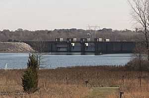
The Alum Creek Dam is also very important. It is part of a plan to control floods in the Ohio River basin. The United States Congress approved building the dam in 1962. Construction started in 1970 and finished in 1974. The United States Army Corps of Engineers built it.
The dam is in Delaware County. Its construction created Alum Creek Lake. The dam's elevation is 833 feet (254 m).
Tributaries of Alum Creek
Tributaries are smaller streams or rivers. They flow into a larger river or lake. Here are some of the streams that flow into Alum Creek:
- West Branch Alum Creek
- Indigo Creek
- Bunker Run
 | Madam C. J. Walker |
 | Janet Emerson Bashen |
 | Annie Turnbo Malone |
 | Maggie L. Walker |


