Chuckery, Ohio facts for kids
Quick facts for kids
Chuckery, Ohio
|
|
|---|---|

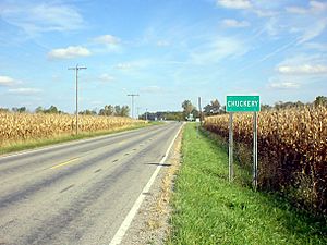
Chuckery sign along Ohio State Route 161
|
|

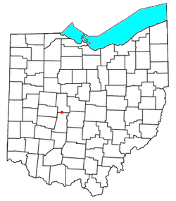
Location of Chuckery, Ohio
|
|
| Country | United States |
| State | Ohio |
| County | Union |
| Elevation | 981 ft (299 m) |
| Time zone | UTC-5 (Eastern (EST)) |
| • Summer (DST) | UTC-4 (EDT) |
| ZIP code |
43064
|
| Area code(s) | 614 |
| GNIS feature ID | 1039100 |
Chuckery is a small place in Ohio, United States. It's known as an "unincorporated community." This means it doesn't have its own local government like a city or town. Instead, it's part of a larger area called Darby Township in Union County.
You can find Chuckery where two main roads, State Route 38 and State Route 161, meet. It's a quiet spot with a history that goes back a long time.
History of Chuckery
Chuckery has been around since the early 1800s. Over the years, its size and importance have changed. Sometimes more people lived there, and sometimes fewer.
Little Darby Creek
A stream called the Little Darby Creek flows right through Chuckery. Around 1921, parts of this stream were "dredged." This means the bottom of the creek was dug out to make it deeper and straighter.
About 6 miles (10 kilometers) of the Little Darby Creek were moved. This was done to stop the stream from winding too much. It also helped to control floods, keeping the area safer from high water. The dredging project started near Irwin and went all the way into Madison County.
Chuckery Post Office
Chuckery used to have its own post office. It opened on April 8, 1898. But it didn't stay open for very long. The post office closed on December 14, 1903. Now, people in Chuckery get their mail through the post office in Plain City.
St. Paul's Lutheran Church
A very important building in Chuckery is St. Paul's Lutheran Church. This church was first started in 1892. The building you see today was built much later, in 1964. It has been a central part of the community for many years.
 | Roy Wilkins |
 | John Lewis |
 | Linda Carol Brown |

