
Marysville, Ohio facts for kids
Quick facts for kids
Marysville, Ohio
|
|||
|---|---|---|---|

Marysville, Ohio as viewed from atop the Historic Uptown grain silo
|
|||
|
|||
| Nickname(s):
The Shaded City, Hondasville
|
|||

Location of Marysville in Union County
|
|||

Marysville, Ohio
Location in Ohio

Marysville, Ohio
Location in the United States
|
|||
| Country | United States | ||
| State | Ohio | ||
| County | Union | ||
| Government | |||
| • Type | Council-City Manager | ||
| Area | |||
| • City | 16.57 sq mi (42.91 km2) | ||
| • Land | 16.28 sq mi (42.16 km2) | ||
| • Water | 0.29 sq mi (0.75 km2) | ||
| Elevation | 1,001 ft (305 m) | ||
| Population
(2020)
|
|||
| • City | 25,571 | ||
| • Density | 1,570.99/sq mi (606.55/km2) | ||
| • Urban | 22,094 | ||
| Time zone | UTC-5 (EST) | ||
| • Summer (DST) | UTC-4 (EDT) | ||
| ZIP codes |
43040-43041
|
||
| Area code(s) | 937, 326 | ||
| FIPS code | 39-48160 | ||
| GNIS feature ID | 2395035 | ||
| Website | https://www.marysvilleohio.org/ | ||


Marysville is a city in Ohio, United States. It is the main city, or county seat, of Union County, Ohio. Marysville is about 27 miles (43 km) northwest of Columbus. In 2020, about 25,571 people lived there. It is part of the larger Columbus area.
Marysville's long-time saying is "Where the Grass is Greener". In 2008, First Lady Laura Bush named the city a "Preserve America Community". This means it's a place that works to protect its history.
Contents
History of Marysville
How Marysville Began
Marysville was first part of the Northwest Territory. Then it became part of Ohio. James Galloway, Jr., one of the first people to survey the land, visited in 1805. Samuel W. Cuthbertson founded Marysville in 1819. He named the town after his daughter, Mary. The town was built along a small stream called Mill Creek.
Becoming the County Seat

After Union County was officially set up, Marysville became its main city. The first meeting of county leaders was in 1820. A courthouse was built between 1835 and 1840. A new, special courthouse was built in Marysville in 1883. This building is still used today.
In 1849, a county infirmary (a place for the sick or poor) was approved. The first county jail was a log building. It was behind the courthouse. A new jail was built in the 1870s. In 1878, the county bought a large safe for its money. This safe was later moved into the courthouse.
The first county fair was held in 1847 in Marysville's public square. In 1852, the fair moved to its current spot. This is on the north side of town.
Early Growth of the City
Marysville was first planned out in 1820. The first person to settle there permanently was Abraham Amrine in 1817. He was from Switzerland. He settled two miles north of the city. Today, a main road to the high school is named Amrine-Mill Rd.

In 1824, the first post office opened. At this time, only four families lived in the village. Marysville's first school opened in 1828. It was in a log cabin on the east side of town. By 1839, there were three schools. In 1843, the first high school opened. By 1850, a Board of Education was making reports to the public.
In 1837, a book called the Ohio Gazetteer described Marysville. It said the town had a courthouse, a jail, 45 houses, one hotel, three stores, a doctor, two lawyers, and about 250 people. By 1846, Marysville had 360 people. It also had three small stores, two churches, a private school, and a newspaper office.
Early businesses included a drug store, a hotel, and a hat shop. The village became an official town in 1840. Otway Curry was elected as the first mayor.
Ladders for a fire department were bought in 1845. By 1865, the village bought its first fire engine. A fire station was built in 1906. It was a two-story brick building.

A count in 1859 showed 981 people living in the village. By 1865, Marysville had six dry goods stores, one hardware store, and many other businesses. It was growing steadily.
In 1877, the town council decided to build a city hall. It was finished in 1878. It held the council rooms, public library, fire department, and city prison. An opera house was also built. In 1877, a nice building for education was built. It had ten rooms for classes. It also had an exhibition hall upstairs. A science and history group started in 1879. Their museum was in this school building.
By 1888, Marysville was known as "the Shaded City." This was because of its many tree-lined streets. By 1890, its population grew to 2,832 people.
Early Factories and Banks
Marysville's factories started with many early companies. One was the Marysville Pearlash Factory, founded in 1848. By 1874, it was the largest in the United States. The first steam-powered mill was built in 1856. In 1867, a flour mill was built. In 1874, the Marysville Butter Tub and Spoke Company started.
A wool company built a factory in 1864. A brewery was built in 1866. In 1868, O.M. Scotts and Company was started. In 1871, the Marysville Cheese Manufacturing Company was built. Many companies made carriages in Marysville.
In 1875, a lumberyard opened. The Marysville Gas Light Company started in 1878. Before this, the city used kerosene for light. The Bank of Marysville opened in 1854. Other banks followed, like the Farmer's Bank of Union County in 1868.

Early Culture and Churches
In 1827, the Methodist Episcopal Church was formed. In 1856, the church opened a new building. The first Fourth of July celebrations were held in 1828.
In 1840, Otway Curry, a famous poet from Marysville, wrote a song. It was called the "Log Cabin Song." This song helped William Henry Harrison win the presidential election that year.
The Presbyterian Church started in 1829. In 1866, people wanted a new church building. A new one was finished in 1870. The Congregational Church started in 1864.
The Church of Our Lady of Lourdes, a Roman Catholic Church, was built in 1866. The German Lutheran Church started in 1875. They also ran their own school.
Modern Growth
Over the next 100 years, Marysville's population grew a lot. A new high school was built. Later, it became a middle school. A newer high school was built in the 1990s. The old middle school became county offices.
In 1948, Nestlé opened a research center. A new city hall was built. Memorial Hospital opened in 1952. Many other things were built, like the Union County Airport in 1967. New factories and neighborhoods also grew. Timberview, a nice neighborhood with a golf course, was built. Greenwood Colony was also built.
In 1977, Honda announced plans to build a motorcycle factory near Marysville. It opened in 1979. Car factories opened in 1982. This caused U.S. Route 33 to be made bigger.
President George H. W. Bush visited Marysville in 1992. He was on a train tour for his re-election campaign.
Geography and Weather
Marysville covers about 16.56 square miles (42.91 km2). Most of this is land, about 16.27 square miles (42.16 km2). A small part, 0.29 square miles (0.75 km2), is water.
Climate in Marysville
Marysville has a climate with warm summers and cold winters. The hottest month is usually July. The coldest month is January. The city gets rain throughout the year. It also gets some snow in winter.
| Climate data for Marysville, Ohio (1991–2020 normals, extremes 1917–present) | |||||||||||||
|---|---|---|---|---|---|---|---|---|---|---|---|---|---|
| Month | Jan | Feb | Mar | Apr | May | Jun | Jul | Aug | Sep | Oct | Nov | Dec | Year |
| Record high °F (°C) | 72 (22) |
75 (24) |
85 (29) |
89 (32) |
95 (35) |
101 (38) |
109 (43) |
105 (41) |
102 (39) |
92 (33) |
80 (27) |
74 (23) |
109 (43) |
| Mean maximum °F (°C) | 57.7 (14.3) |
61.6 (16.4) |
71.6 (22.0) |
81.1 (27.3) |
88.4 (31.3) |
93.0 (33.9) |
93.2 (34.0) |
92.2 (33.4) |
90.3 (32.4) |
82.7 (28.2) |
68.9 (20.5) |
60.5 (15.8) |
94.5 (34.7) |
| Mean daily maximum °F (°C) | 35.0 (1.7) |
38.9 (3.8) |
49.6 (9.8) |
63.0 (17.2) |
73.6 (23.1) |
81.7 (27.6) |
84.9 (29.4) |
83.5 (28.6) |
77.5 (25.3) |
65.0 (18.3) |
50.9 (10.5) |
39.6 (4.2) |
61.9 (16.6) |
| Daily mean °F (°C) | 27.8 (−2.3) |
30.9 (−0.6) |
40.2 (4.6) |
52.0 (11.1) |
62.7 (17.1) |
71.2 (21.8) |
74.7 (23.7) |
73.0 (22.8) |
66.1 (18.9) |
54.4 (12.4) |
42.3 (5.7) |
32.9 (0.5) |
52.3 (11.3) |
| Mean daily minimum °F (°C) | 20.6 (−6.3) |
22.9 (−5.1) |
30.8 (−0.7) |
41.0 (5.0) |
51.8 (11.0) |
60.8 (16.0) |
64.4 (18.0) |
62.4 (16.9) |
54.7 (12.6) |
43.8 (6.6) |
33.7 (0.9) |
26.1 (−3.3) |
42.7 (5.9) |
| Mean minimum °F (°C) | 0.4 (−17.6) |
4.4 (−15.3) |
13.3 (−10.4) |
26.2 (−3.2) |
38.3 (3.5) |
47.3 (8.5) |
53.1 (11.7) |
50.9 (10.5) |
41.0 (5.0) |
30.7 (−0.7) |
20.1 (−6.6) |
10.0 (−12.2) |
−3.0 (−19.4) |
| Record low °F (°C) | −23 (−31) |
−19 (−28) |
−11 (−24) |
8 (−13) |
22 (−6) |
36 (2) |
42 (6) |
36 (2) |
27 (−3) |
12 (−11) |
−6 (−21) |
−20 (−29) |
−23 (−31) |
| Average precipitation inches (mm) | 2.68 (68) |
2.29 (58) |
3.02 (77) |
3.86 (98) |
4.52 (115) |
4.85 (123) |
4.15 (105) |
3.41 (87) |
3.20 (81) |
2.72 (69) |
2.90 (74) |
2.88 (73) |
40.48 (1,028) |
| Average snowfall inches (cm) | 7.0 (18) |
6.6 (17) |
4.1 (10) |
0.1 (0.25) |
0.0 (0.0) |
0.0 (0.0) |
0.0 (0.0) |
0.0 (0.0) |
0.0 (0.0) |
0.0 (0.0) |
0.7 (1.8) |
5.5 (14) |
24.0 (61) |
| Average precipitation days (≥ 0.01 in) | 11.1 | 10.0 | 10.8 | 12.1 | 13.6 | 11.7 | 10.3 | 8.7 | 8.8 | 8.9 | 9.5 | 10.9 | 126.4 |
| Average snowy days (≥ 0.1 in) | 6.1 | 4.3 | 2.2 | 0.2 | 0.0 | 0.0 | 0.0 | 0.0 | 0.0 | 0.0 | 0.8 | 3.6 | 17.5 |
| Source: NOAA | |||||||||||||
Population of Marysville
| Historical population | |||
|---|---|---|---|
| Census | Pop. | %± | |
| 1840 | 360 | — | |
| 1850 | 605 | 68.1% | |
| 1860 | 849 | 40.3% | |
| 1870 | 1,441 | 69.7% | |
| 1880 | 2,061 | 43.0% | |
| 1890 | 2,810 | 36.3% | |
| 1900 | 3,048 | 8.5% | |
| 1910 | 3,576 | 17.3% | |
| 1920 | 3,035 | −15.1% | |
| 1930 | 3,639 | 19.9% | |
| 1940 | 4,037 | 10.9% | |
| 1950 | 4,256 | 5.4% | |
| 1960 | 4,952 | 16.4% | |
| 1970 | 5,744 | 16.0% | |
| 1980 | 7,403 | 28.9% | |
| 1990 | 9,656 | 30.4% | |
| 2000 | 15,942 | 65.1% | |
| 2010 | 22,094 | 38.6% | |
| 2020 | 25,571 | 15.7% | |
| Sources: | |||
In 2000, the average income for a family in Marysville was $55,671. The average income for men was $40,973, and for women it was $27,427. About 5.7% of the people lived below the poverty line. This included 5.3% of those under 18. The average price for a home in Marysville was $168,100 in 2010.
Marysville in 2010
In 2010, there were 22,094 people living in Marysville. There were 7,314 households, which are groups of people living together. The city had about 1,358 people per square mile (524 per km2).
Most people in Marysville were White (90.4%). Other groups included African American (4.5%) and Asian (2.3%). About 1.8% of the people were Hispanic or Latino.
About 41.7% of households had children under 18. Most households (53.1%) were married couples. The average age in the city was 33.1 years. About 26.6% of residents were under 18.
Economy and Jobs

Marysville is home to the main office of Scotts Miracle-Gro Company. This company is the world's largest maker of horticulture (garden and plant care) products. Orlando Scott started the company in Marysville in 1868. Today, it is a very large company.
Honda has big factories near Marysville. The first Honda factories in the United States opened here. This included the Marysville Motorcycle Plant (1979-2009) and the Marysville Auto Plant (1982). The Marysville Auto Plant has been the main place where the Honda Accord car is made since 1982.
Marysville also has the main office for Univenture. This company makes packaging for media like CDs and DVDs. There is also a Parker Hannifin factory. A Goodyear factory, called Veyance Technologies, is also in the city.

Marysville is also a place for research and development. Nestlé has a center here that works on ready-to-drink mixes. Scotts Miracle-Gro also does its research here. The Transportation Research Center is a few miles away. It is near the Honda factories. A part of Univenture, Algae Venture Systems, found a way to make algae for cheap biofuel.
Arts and Fun Activities

Marysville hosts fun events all year. These include:
- The Union County Fair (late July-early August)
- Festifair (Saturday after Labor Day)
There are many horse farms and riding centers in the Marysville area. You can also find several local golf clubs. The Piatt Castles, Covered Bridges of Union County, and the Big Darby Plains Scenic Byway are close by.
The Scotts Miracle-Gro museum is just south of the square in Uptown. The Marysville Public Library is on Plum Street.
Parks and Recreation

Marysville has many parks, covering over 300 acres (1.2 km2). These parks have:
- Walking and bike trails along Mill Creek. You can find these trails at Aldersgate, Eljers, McCarthy, Mill Creek, Mill Valley South and Central, and Shwartzkopf parks.
- An amphitheater at the American Legion park.
- Soccer and baseball fields at Eljer, Lewis, Mill Creek, and Mill Valley South and Central parks.
- Lighted tennis courts at Eljer and Lewis parks.
- Basketball courts at the American Legion and Aldersgate park. Eljer and Lewis parks have lighted courts.
- A football field at Lewis park.
- Fishing spots at Aldersgate, McCarthy, Mill Creek, Mill Valley Central, and Shwartzkopf parks.
- A nature preserve at MacIvor Woods.
- A Frisbee golf course and a skateboard park at Eljer Park.
Education in Marysville

Most of Marysville is part of the Marysville Exempted Village Schools District. A small part of the land is in the Fairbanks Local School District. Marysville High School is the main high school for the Marysville district.
Besides the public schools, there are other choices for learning. St. John's Lutheran School and Trinity Lutheran School are church-based schools. They teach students up to middle school. The LEADS Head Start program helps younger children. It is for families who qualify based on their income.
The Columbus Japanese Language School holds its classes in Marysville. It is a weekend school for Japanese students.
Media and News
The Marysville Journal-Tribune is the oldest newspaper in the city. It started in 1849. The Gaumer-Behrens family has owned it since 1904. Their online newspaper has won awards.
City Services
Getting Around
The Union County Airport is in Marysville. It has a long runway for planes. It can be used for passenger and cargo flights. Private planes can also use it.
U.S. Route 33 is a four-lane highway that goes through Marysville. It connects the city to bigger highways. These include Interstate 75 to the northwest. It also connects to I-270 near Columbus. I-270 links to Interstates 70 and 71. Route 33 is an important road in Ohio.
Marysville has train service for cargo. This is provided by CSX. There are no passenger trains.
Water and Power
The city opened new sewer systems and a water reservoir in 2009. Union County is one of the fastest-growing counties in Ohio.
In 2009, Marysville was the first city in Central Ohio to use inflatable dam technology. This dam was built on Mill Creek. It is part of the new water system.
The city of Marysville gets its power from Dayton Power and Light. Other areas nearby get power from Union Rural Electric and AEP Ohio.
State Prison
Marysville is home to the Ohio Reformatory for Women. This is a state prison for women.
Healthcare Services

Marysville has many doctors' offices. It is also home to Memorial Health. The hospital recently had a big update. It is now a 107-bed building. It has an emergency room and many other services. These include lab tests and imaging. They also offer long-term nursing care.
In 2009, Memorial was named one of the most high-tech hospitals. The Ohio State University Heart Center opened there in 2009. In 2014, Memorial opened the City Gate Medical Center. This center has sports medicine, physical therapy, and urgent care. Marysville also has several chiropractic offices.
Notable People from Marysville
- Robert S. Beightler, a military general and engineer. He helped build the modern Interstate Highway System and Ohio Turnpike.
- Chase Blackburn, a football player.
- Arthur E. Drumm, an inventor and factory owner. He helped create industrial brooms.
- Cornelia Cole Fairbanks, a former leader of the Daughters of the American Revolution.
- Charles Coleman Finlay, a science fiction and fantasy writer.
- Darren Hall, a baseball player.
- Cornelius S. Hamilton, a United States Congressman.
- John F. Kinney, a judge and politician.
- Natalia Laschenova, a former gymnast from Soviet Latvia. She won an Olympic gold medal in 1988.
- Reuben Partridge, an early settler and bridge builder.
- Preston B. Plumb, a United States Senator.
- James Wallace Robinson, a United States Congressman.
- Orlando Scott, who started the O.M. Scott and Sons Company. This company later became the Scotts Miracle-Gro Company.
- Gary Shirk, a football player.
- Thomas B. Ward, a United States Congressman.
Sister City
 Yorii, Japan (since 2013)
Images for kids
-
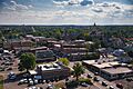
Marysville, Ohio as viewed from atop the Historic Uptown grain silo
-
Flag of Marysville, Ohio
-

Logo of Marysville, Ohio
-
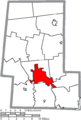
Location of Marysville in Union County
See also
 In Spanish: Marysville (Ohio) para niños
