
Muskingum County, Ohio facts for kids
Quick facts for kids
Muskingum County
|
|||
|---|---|---|---|

Muskingum County Courthouse
|
|||
|
|||

Location within the U.S. state of Ohio
|
|||
 Ohio's location within the U.S. |
|||
| Country | |||
| State | |||
| Founded | March 1, 1804 | ||
| Named for | A Native American word meaning "swampy ground" | ||
| Seat | Zanesville | ||
| Largest city | Zanesville | ||
| Area | |||
| • Total | 673 sq mi (1,740 km2) | ||
| • Land | 665 sq mi (1,720 km2) | ||
| • Water | 8.0 sq mi (21 km2) 1.2%% | ||
| Population
(2020)
|
|||
| • Total | 86,410 |
||
| • Density | 130/sq mi (50/km2) | ||
| Time zone | UTC−5 (Eastern) | ||
| • Summer (DST) | UTC−4 (EDT) | ||
| Congressional district | 12th | ||


Muskingum County is a county in the east-central part of Ohio. As of 2020, about 86,410 people live there. Its main city, or county seat, is Zanesville. The Muskingum River flows through the county.
The county's name comes from a Delaware Native American word. It means "town by the river" or "elk's eye." Muskingum County is part of a larger area that includes Columbus.
Contents
What's in a Name?
The name Muskingum has a few possible meanings. It might come from the Shawnee word mshkikwam, which means 'swampy ground'.
Another idea is that it comes from the Lenape word "Machkigen." This word refers to thorns or a specific type of thorn bush.
Some people also believe Muskingum means 'elk's eye'. This comes from the words mus (elk) and wəshkinkw (its eye). An old missionary named David Zeisberger wrote that the Muskingum River was called Elk's Eye. He said this was because many elk used to feed along its banks.
Geography and Land
_(cropped).jpg)
Muskingum County covers about 673 square miles. Most of this is land (665 square miles), and a small part (8 square miles) is water. It is the fourth-largest county in Ohio by land area.
Neighboring Counties
Muskingum County shares borders with several other counties:
- Coshocton County to the north
- Guernsey County to the east
- Noble County to the southeast
- Morgan County to the south
- Perry County to the southwest
- Licking County to the west
Population Facts
| Historical population | |||
|---|---|---|---|
| Census | Pop. | %± | |
| 1810 | 10,036 | — | |
| 1820 | 17,824 | 77.6% | |
| 1830 | 29,334 | 64.6% | |
| 1840 | 38,749 | 32.1% | |
| 1850 | 45,049 | 16.3% | |
| 1860 | 44,416 | −1.4% | |
| 1870 | 44,886 | 1.1% | |
| 1880 | 49,774 | 10.9% | |
| 1890 | 51,210 | 2.9% | |
| 1900 | 53,185 | 3.9% | |
| 1910 | 57,488 | 8.1% | |
| 1920 | 57,980 | 0.9% | |
| 1930 | 67,398 | 16.2% | |
| 1940 | 69,795 | 3.6% | |
| 1950 | 74,535 | 6.8% | |
| 1960 | 79,159 | 6.2% | |
| 1970 | 77,826 | −1.7% | |
| 1980 | 83,340 | 7.1% | |
| 1990 | 82,068 | −1.5% | |
| 2000 | 84,585 | 3.1% | |
| 2010 | 86,074 | 1.8% | |
| 2020 | 86,410 | 0.4% | |
| U.S. Decennial Census 1790-1960 1900-1990 1990-2000 2020 |
|||
In 2010, there were 86,074 people living in Muskingum County. The population density was about 129 people per square mile. Most people in the county were white (93.0%). The average household had about 2.46 people. The average age of people living in the county was 39.5 years old.
Education
Muskingum County has several schools and colleges.
High Schools
There are seven high schools in the county:
- John Glenn High School in New Concord
- Philo High School in Duncan Falls
- Maysville High School in South Zanesville
- Bishop Rosecrans (a Catholic school in Zanesville)
- Tri-Valley High School in Dresden
- West Muskingum High School in Zanesville
- Zanesville High School in Zanesville
Colleges
The county also has three colleges:
- Muskingum University
- Zane State College
- A branch of Ohio University called Ohio University Zanesville
Culture and Fun
The Muskingum County Library System helps people in the county find books and information. It has offices in Zanesville, Ohio and serves towns like Dresden, Duncan Falls, New Concord, and Roseville. In 2005, the library loaned out over 918,000 items!
The Wilds is a very large wildlife preserve. It covers over 9,154 acres (about 37 square kilometers). Visitors can go there to see many different animals.
Communities
Muskingum County has one main city, several villages, many townships, and other smaller communities.
City
- Zanesville (This is the county seat, meaning it's where the county government is located.)
Villages
Townships
- Adams
- Blue Rock
- Brush Creek
- Cass
- Clay
- Falls
- Harrison
- Highland
- Hopewell
- Jackson
- Jefferson
- Licking
- Madison
- Meigs
- Monroe
- Muskingum
- Newton
- Perry
- Rich Hill
- Salem
- Salt Creek
- Springfield
- Union
- Washington
- Wayne
Census-Designated Places
These are areas that are like towns but are not officially incorporated as cities or villages.
Other Communities
These are smaller, unincorporated places in the county.
- Adams Mills
- Bloomfield
- Blue Rock
- Bridgeville
- Chandlersville
- Coal Hill
- Dillon Falls
- Ellis
- Freeland
- Gaysport
- Gilbert
- High Hill
- Hopewell
- Irville
- Licking View
- Mattingly Settlement
- Meadow Farm
- Mount Sterling
- Museville
- Nashport
- Otsego
- Rix Mills
- Ruraldale
- Sonora
- Stovertown
- Sundale
- White Cottage
- Young Hickory
- Zeno
Images for kids
-
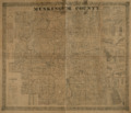
This is a historic map of Muskingum County from 1852.
-
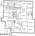
Map of Muskingum County, Ohio with city and township names.

See also
 In Spanish: Condado de Muskingum para niños
