Perry County, Ohio facts for kids
Quick facts for kids
Perry County
|
|||
|---|---|---|---|

|
|||
|
|||

Location within the U.S. state of Ohio
|
|||
 Ohio's location within the U.S. |
|||
| Country | |||
| State | |||
| Founded | March 1, 1818 | ||
| Named for | Oliver Hazard Perry | ||
| Seat | New Lexington | ||
| Largest City | New Lexington | ||
| Area | |||
| • Total | 412 sq mi (1,070 km2) | ||
| • Land | 408 sq mi (1,060 km2) | ||
| • Water | 4.5 sq mi (12 km2) 1.1%% | ||
| Population
(2020)
|
|||
| • Total | 35,408 |
||
| • Density | 86/sq mi (33/km2) | ||
| Time zone | UTC−5 (Eastern) | ||
| • Summer (DST) | UTC−4 (EDT) | ||
| Congressional district | 12th | ||
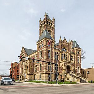
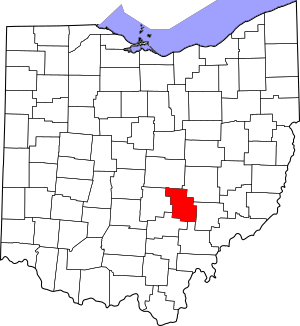
Perry County is a place in the state of Ohio, United States. It's like a big neighborhood with its own local government. In 2020, about 35,408 people lived here. The main town, or county seat, where the county government is located, is New Lexington.
Perry County was officially started on March 1, 1818. It was made from parts of other nearby counties: Fairfield, Washington, and Muskingum. The county got its name from Oliver Hazard Perry. He was a famous hero from the War of 1812, a conflict between the United States and Great Britain.
Perry County is also part of the larger Columbus, OH Metropolitan Statistical Area. This means it's connected to the bigger city of Columbus for things like jobs and services. A famous legal case about school funding in Ohio, called DeRolph v. State, actually started right here in Perry County. This case was about making sure schools across the state had enough money.
Contents
Geography of Perry County
Perry County covers a total area of about 412 square miles. Most of this area, about 408 square miles, is land. The rest, about 4.5 square miles, is water, which is about 1.1% of the total area.
Counties Nearby
Perry County shares its borders with several other counties:
- Licking County to the north
- Muskingum County to the northeast
- Morgan County to the southeast
- Athens County to the south
- Hocking County to the southwest
- Fairfield County to the west
Protected Natural Areas
A small part of the Wayne National Forest is located within Perry County. This is a large area of protected land, great for nature and outdoor activities.
People of Perry County
| Historical population | |||
|---|---|---|---|
| Census | Pop. | %± | |
| 1820 | 8,429 | — | |
| 1830 | 13,970 | 65.7% | |
| 1840 | 19,344 | 38.5% | |
| 1850 | 20,775 | 7.4% | |
| 1860 | 19,678 | −5.3% | |
| 1870 | 18,453 | −6.2% | |
| 1880 | 28,218 | 52.9% | |
| 1890 | 31,151 | 10.4% | |
| 1900 | 31,841 | 2.2% | |
| 1910 | 35,396 | 11.2% | |
| 1920 | 36,098 | 2.0% | |
| 1930 | 31,445 | −12.9% | |
| 1940 | 31,087 | −1.1% | |
| 1950 | 28,999 | −6.7% | |
| 1960 | 27,864 | −3.9% | |
| 1970 | 27,434 | −1.5% | |
| 1980 | 31,032 | 13.1% | |
| 1990 | 31,557 | 1.7% | |
| 2000 | 34,078 | 8.0% | |
| 2010 | 36,058 | 5.8% | |
| 2020 | 35,408 | −1.8% | |
| U.S. Decennial Census 1790-1960 1900-1990 1990-2000 2020 |
|||
Population in 2010
In 2010, there were 36,058 people living in Perry County. These people lived in 13,576 homes, and 9,738 of these were families. The county had about 88 people per square mile. There were also 15,211 housing units, like houses or apartments.
Most people in the county, about 97.9%, were white. A small number were Black or African American (0.3%), American Indian (0.2%), or Asian (0.1%). About 1.4% of people were from two or more racial backgrounds. About 0.5% of the population identified as Hispanic or Latino.
When it came to family backgrounds, many people had roots in Germany (25.4%), Ireland (14.9%), or England (10.4%). About 9.6% identified simply as American.
In 2010, about 35.7% of homes had children under 18 living there. About 54.3% of homes were married couples. The average age of people in the county was 38.6 years old.
The median income for a household in the county was $42,388. This means half of the households earned more than this amount, and half earned less. For families, the median income was $50,489.
Towns and Villages
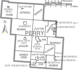
Perry County has many different communities, from small villages to larger townships.
Villages
- Corning
- Crooksville
- Glenford
- Hemlock
- Junction City
- New Lexington (This is the county seat!)
- New Straitsville
- Rendville
- Roseville (Part of this village is in another county)
- Shawnee
- Somerset (This used to be the county seat)
- Thornville
Townships
- Bearfield
- Clayton
- Coal
- Harrison
- Hopewell
- Jackson
- Madison
- Monday Creek
- Monroe
- Pike
- Pleasant
- Reading
- Salt Lick
- Thorn
Census-Designated Places
These are areas that are like towns but are not officially incorporated as villages or cities.
Unincorporated Communities
These are smaller communities that are not part of any village or city.
Ghost Towns
These are places where people used to live, but now they are mostly abandoned.
See also
 In Spanish: Condado de Perry (Ohio) para niños
 | Delilah Pierce |
 | Gordon Parks |
 | Augusta Savage |
 | Charles Ethan Porter |


