Hocking County, Ohio facts for kids
Quick facts for kids
Hocking County
|
|||
|---|---|---|---|

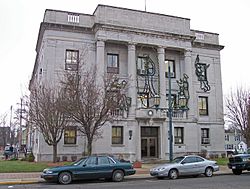
Hocking County Courthouse
|
|||
|
|||

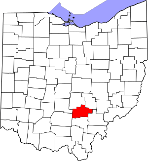
Location within the U.S. state of Ohio
|
|||
 Ohio's location within the U.S. |
|||
| Country | |||
| State | |||
| Founded | March 1, 1818 | ||
| Named for | Hocking River, perhaps from the Lenape language for "bottle river" | ||
| Seat | Logan | ||
| Largest city | Logan | ||
| Area | |||
| • Total | 424 sq mi (1,100 km2) | ||
| • Land | 421 sq mi (1,090 km2) | ||
| • Water | 2.3 sq mi (6 km2) 0.5%% | ||
| Population
(2020)
|
|||
| • Total | 28,050 |
||
| • Density | 66/sq mi (25/km2) | ||
| Time zone | UTC−5 (Eastern) | ||
| • Summer (DST) | UTC−4 (EDT) | ||
| Congressional district | 2nd | ||
Hocking County is a place in Ohio, USA. It's one of the many counties that make up the state.
In 2020, about 28,050 people lived there. The main town, or county seat, is Logan. Hocking County officially started on March 1, 1818. It was formed from parts of other nearby counties.
The county gets its name from the Hocking River. Some say "Hocking" is an old Native American word. It might mean "bottle river." Hocking County is also part of the larger Columbus, Ohio, city area.
Contents
Exploring Hocking County's Land
According to official records, Hocking County covers about 424 square miles. Most of this area, about 421 square miles, is land. A small part, about 2.3 square miles, is water.
Rivers and Streams
The most important river in Hocking County is the Hocking River. It flows from the northwest to the southeast. This river starts in Fairfield County and then goes through Hocking County. It eventually flows into Athens County. The Hocking River drains about half of the county's land.
Other important waterways include Salt Creek. It flows through the southwest part of the county. Raccoon Creek drains a small area in the southeast. The easternmost part of the county is in the Monday Creek area. A small northern section is drained by Rush Creek.
Neighboring Counties
Hocking County shares its borders with several other counties:
- Perry County (to the northeast)
- Athens County (to the southeast)
- Vinton County (to the south)
- Ross County (to the southwest)
- Pickaway County (to the west)
- Fairfield County (to the northwest)
Protected Natural Areas
A part of the large Wayne National Forest is located in Hocking County. This forest helps protect nature and wildlife.
Who Lives in Hocking County?
| Historical population | |||
|---|---|---|---|
| Census | Pop. | %± | |
| 1820 | 2,130 | — | |
| 1830 | 4,008 | 88.2% | |
| 1840 | 9,741 | 143.0% | |
| 1850 | 14,119 | 44.9% | |
| 1860 | 17,057 | 20.8% | |
| 1870 | 17,925 | 5.1% | |
| 1880 | 21,126 | 17.9% | |
| 1890 | 22,658 | 7.3% | |
| 1900 | 24,398 | 7.7% | |
| 1910 | 23,650 | −3.1% | |
| 1920 | 23,291 | −1.5% | |
| 1930 | 20,407 | −12.4% | |
| 1940 | 21,504 | 5.4% | |
| 1950 | 19,520 | −9.2% | |
| 1960 | 20,168 | 3.3% | |
| 1970 | 20,322 | 0.8% | |
| 1980 | 24,304 | 19.6% | |
| 1990 | 25,533 | 5.1% | |
| 2000 | 28,241 | 10.6% | |
| 2010 | 29,380 | 4.0% | |
| 2020 | 28,050 | −4.5% | |
| U.S. Decennial Census 1790-1960 1900-1990 1990-2000 2020 |
|||
Population Facts
In 2010, about 29,380 people lived in Hocking County. There were 11,369 households, which are groups of people living together. The county had about 70 people per square mile.
Most people living in Hocking County were white (97.5%). A small number were Black or African American (0.7%). Other groups included American Indian, Asian, and people of two or more races. About 0.7% of the population was of Hispanic or Latino background.
Many families had children under 18 living with them (32.3%). Most households were married couples (53.9%). The average age of people in the county was about 40.9 years old.
The average income for a household was around $39,586 per year. For families, it was about $48,796. About 15.3% of the people lived below the poverty line. This included 20.7% of those under 18 years old.
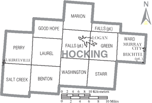
Towns and Communities
Hocking County has one city, several villages, and many smaller communities.
City
- Logan (This is the county seat, the main town where the county government is located.)
Villages
Townships
- Benton
- Falls
- Good Hope
- Green
- Laurel
- Marion
- Perry
- Salt Creek
- Starr
- Ward
- Washington
Census-Designated Places
These are areas that are like towns but are not officially incorporated as cities or villages.
- Carbon Hill
- Haydenville
- Hide-A-Way Hills
- Rockbridge
- West Logan
Unincorporated Communities
These are smaller places that are not officially part of any city or village.
See also
 In Spanish: Condado de Hocking para niños
 | Ernest Everett Just |
 | Mary Jackson |
 | Emmett Chappelle |
 | Marie Maynard Daly |


