Vinton County, Ohio facts for kids
Quick facts for kids
Vinton County
|
|||
|---|---|---|---|
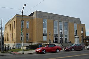
Vinton County Courthouse in McArthur
|
|||
|
|||
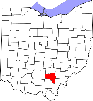
Location within the U.S. state of Ohio
|
|||
 Ohio's location within the U.S. |
|||
| Country | |||
| State | |||
| Founded | March 23, 1850 | ||
| Named for | Samuel Finley Vinton | ||
| Seat | McArthur | ||
| Largest village | McArthur | ||
| Area | |||
| • Total | 415 sq mi (1,070 km2) | ||
| • Land | 412 sq mi (1,070 km2) | ||
| • Water | 2.6 sq mi (7 km2) 0.6% | ||
| Population
(2020)
|
|||
| • Total | 12,800 | ||
| • Estimate
(2023)
|
12,474 |
||
| • Density | 30.84/sq mi (11.91/km2) | ||
| Time zone | UTC−5 (Eastern) | ||
| • Summer (DST) | UTC−4 (EDT) | ||
| Congressional district | 2nd | ||
| Website | http://www.vintoncounty.com/ | ||
Vinton County is a small county located in the state of Ohio, USA. In 2020, about 12,800 people lived there. This makes it the county with the fewest people in Ohio. The main town, or county seat, is McArthur. The county got its name from Samuel Finley Vinton. He was a very important person who represented Ohio in the US government for many years.
Contents
History of Vinton County
In the 1800s, Vinton County was a place where iron was made. There were at least three special furnaces that produced iron. In 1926, a woman named Maude Collins made history. She became the first female sheriff in all of Ohio.
Geography of Vinton County
Vinton County covers about 415 square miles. Most of this area, about 412 square miles, is land. The rest, about 2.6 square miles, is water.
Rivers and Streams
Most of the water in Vinton County flows into Raccoon Creek. This area is called the Raccoon Creek watershed. A smaller part of the county, to the west, is in the Salt Creek watershed.
Neighboring Counties
Vinton County shares its borders with several other counties:
- Hocking County (to the north)
- Athens County (to the northeast)
- Meigs County (to the east)
- Gallia County (to the southeast)
- Jackson County (to the south)
- Ross County (to the west)
Population and People
| Historical population | |||
|---|---|---|---|
| Census | Pop. | %± | |
| 1850 | 9,353 | — | |
| 1860 | 13,631 | 45.7% | |
| 1870 | 15,027 | 10.2% | |
| 1880 | 17,223 | 14.6% | |
| 1890 | 16,045 | −6.8% | |
| 1900 | 15,330 | −4.5% | |
| 1910 | 13,096 | −14.6% | |
| 1920 | 12,075 | −7.8% | |
| 1930 | 10,287 | −14.8% | |
| 1940 | 11,573 | 12.5% | |
| 1950 | 10,759 | −7.0% | |
| 1960 | 10,274 | −4.5% | |
| 1970 | 9,420 | −8.3% | |
| 1980 | 11,584 | 23.0% | |
| 1990 | 11,098 | −4.2% | |
| 2000 | 12,806 | 15.4% | |
| 2010 | 13,435 | 4.9% | |
| 2020 | 12,800 | −4.7% | |
| 2021 (est.) | 12,696 | −5.5% | |
| U.S. Decennial Census 1790-1960 1900-1990 1990-2000 2010-2020 |
|||
How Many People Live Here?
In 2010, there were 13,435 people living in Vinton County. These people lived in 5,260 homes. About 3,640 of these were families. The county had about 32 people per square mile. Most people in the county, about 97.9%, were white. Other groups included American Indian, Black, and Asian people. About 0.5% of the population was of Hispanic or Latino origin.
Many families had children under 18 living with them. The average age of people in the county was about 39.6 years old.
Education in Vinton County
All the schools in Vinton County are part of the Vinton County Local School District. Here are the schools:
- West Elementary
- Located at 57750 US Highway 50, Allensville, Ohio 45651
- South Elementary
- Located at 38234 State Route 93, Hamden, Ohio 45634
- Central Elementary
- Located at 507 Jefferson Avenue, McArthur, Ohio 45651
- Vinton County Middle School
- Located at 63780 Locker Plant Road, McArthur, Ohio 45651
- Vinton County High School
- Located at 63910 US Highway 50, McArthur, Ohio 45651
Transportation and Roads
Main Roads
Many important roads run through Vinton County. These include:
Vinton County Airport
Vinton County has its own public airport, called Vinton County Airport. It has one runway that is 3,725 feet long. This runway is made of asphalt and runs east to west. The airport is used for small planes and offers flight lessons. A local group works to raise money to keep the airport in good shape.
Local News
The local newspaper for Vinton County is called The Courier. It is available both in print and online.
Things to See and Do
Covered Bridges
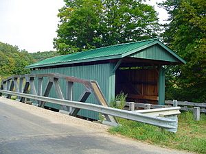
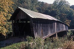
Vinton County is home to several old covered bridges.
- The Ponn Bridge was built in 1874. It was the longest covered bridge in the county. Sadly, it was burned down in 2013.
- The Mt. Olive Bridge was built in 1875. It is open for people to walk across and goes over the Middle Fork Salt Creek.
- The Bay Bridge is located at the Vinton County Fairgrounds. It was moved there in 1967 and is still open for walkers.
- The Cox Bridge was built in 1884. It is also open for walking and has a picnic area nearby.
- The Arbaugh Bridge was built in 1871. It is the oldest covered bridge in the county. This bridge is special because it's the only one that cars can still drive on, thanks to recent updates.
State Parks and Forests
Vinton County has many beautiful outdoor areas. There are eight recreation spots in total.
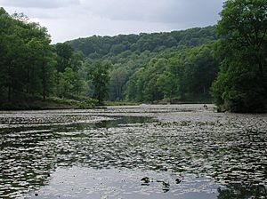
- State Parks: Lake Alma State Park (near Wellston, Ohio) and Lake Hope State Park (near McArthur, Ohio).
- State Forests: Richland Furnace State Forest, Tar Hollow State Forest, Vinton Furnace State Forest, and Zaleski State Forest.
- Other Areas: Part of the Wayne National Forest is in Vinton County. There is also the Raccoon Ecological Management Area and the Wellston Wildlife Area with Lake Rupert. Over 70% of Vinton County is covered in trees!
Hocking Hills Region
Just north of Vinton County is the popular Hocking Hills Region. Many visitors choose to stay in Vinton County to avoid the bigger crowds in Hocking Hills.
Lake Hope Bike Trails
Lake Hope State Park has five different bike trails. They range from 4.5 miles to 16 miles long. The shortest is the Hope Furnace Trail loop. The longest is the Old Big Loop.
Zaleski Backpack Trails
Zaleski State Forest offers two hiking trails. One is a long 23.5-mile trail for backpackers. The other is a shorter 10-mile trail for day trips.
Moonville Rail-Trail
The Moonville Rail-Trail is a 16-mile path for walking and biking. It follows an old railroad line. The trail is named after the ghost town of Moonville. You can see a brick tunnel and a wooden tunnel along the way. The trail goes through Zaleski State Forest, passing through forests and wetlands. A local group is working to fix up the trail and replace old bridges.
Quilt Barns
You can find 27 special "quilt barns" scattered along the roads in Vinton County. These barns have large painted quilt patterns on them. They are part of Vinton County's Quilt Trail.
|
|
|
|
Fun Events
Wild Turkey Festival
The Wild Turkey Festival is a music festival held in McArthur, Ohio. It happens on the first weekend of May. There's a parade through town on Saturday night.
Ridgetop Music Festival
Every August, the Ridgetop Music Festival takes place at the Vinton County Airport. You can enjoy music and even take airplane rides during the festival.
Vinton County Air Show
The air show is held on the third Sunday in September. It's the biggest free air show in Ohio! You can watch amazing aerial acts and enjoy food.
Midnight At Moonville
Midnight at Moonville is a Halloween-themed festival. It features exciting storytelling, wagon rides, local crafts, and music. It takes place at the Moonville Tunnel.
Towns and Communities
Villages
- Hamden
- McArthur (the county seat)
- Wilkesville
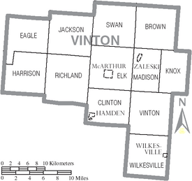
- Zaleski
Townships
- Brown
- Clinton
- Eagle
- Elk
- Harrison
- Jackson
- Knox
- Madison
- Richland
- Swan
- Vinton
- Wilkesville
Other Communities
- Allensville
- Creola
- Dundas
- Eagle Mills
- Hawks
- Hope
- Hue
- Jimtown
- Knox
- Minerton
- New Plymouth
- Orland
- Prattsville
- Puritan
- Radcliff
- Ratcliffburg
- Ray
- Siverly
- Stella
- Vales Mills
- Tiffin, Ohio
Ghost Towns
Some towns in Vinton County are now "ghost towns," meaning no one lives there anymore. These include:
See also
 In Spanish: Condado de Vinton para niños
 | Lonnie Johnson |
 | Granville Woods |
 | Lewis Howard Latimer |
 | James West |


