Meigs County, Ohio facts for kids
Quick facts for kids
Meigs County
|
|||
|---|---|---|---|

County courthouse in Pomeroy
|
|||
|
|||

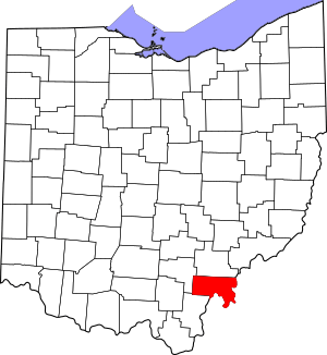
Location within the U.S. state of Ohio
|
|||
 Ohio's location within the U.S. |
|||
| Country | |||
| State | |||
| Founded | April 1, 1819 | ||
| Named for | Return J. Meigs Jr. | ||
| Seat | Pomeroy | ||
| Largest village | Middleport | ||
| Area | |||
| • Total | 433 sq mi (1,120 km2) | ||
| • Land | 430 sq mi (1,100 km2) | ||
| • Water | 2.9 sq mi (8 km2) 0.7%% | ||
| Population
(2020)
|
|||
| • Total | 22,210 |
||
| • Density | 51/sq mi (20/km2) | ||
| Time zone | UTC−5 (Eastern) | ||
| • Summer (DST) | UTC−4 (EDT) | ||
| Congressional district | 2nd | ||
Meigs County (pronounced MEGZ) is a county in the state of Ohio. In 2020, about 22,210 people lived there. The main town, or county seat, is Pomeroy. The county got its name from Return J. Meigs Jr., who was the fourth Governor of Ohio.
Contents
Geography of Meigs County
The U.S. Census Bureau says that Meigs County covers about 433 square miles. Most of this area, about 430 square miles, is land. The rest, about 2.9 square miles, is water. The Ohio River forms the eastern and southern edges of the county. On the other side of the river is West Virginia.
Meigs County is part of the Appalachian Mountains, in a hilly area called the Appalachian Plateau. The land here can be gently rolling or quite rugged. The lowest points are around 535 feet above sea level near the Ohio River. The highest points reach about 1,020 feet above sea level in the southwest. Most of the county's water flows into the Ohio River through two smaller rivers: Shade River and Leading Creek. Raccoon Creek also flows through a small part of the county.
Coal mining was a very important industry in Meigs County for many years. It started in the late 1800s and continued until the 1990s. Even today, you can still see signs of mining in the landscape. These include high walls and piles of leftover rock. Some streams in the Leading Creek area still have problems from old mine water.
In 2009, a company opened a new coal mine and plant near Racine. This project cost $75 million. It can employ 120 to 150 miners. The mine can produce 3.5 million tons of coal each year.
Climate
Meigs County has a humid continental climate. This means it has warm to hot, humid summers. Winters are cool to cold and wet. The county gets about 41 inches of rain each year, spread out evenly.
In July, high temperatures are usually in the upper 80s Fahrenheit. Lows are in the low to mid-60s Fahrenheit. Temperatures above 90 degrees Fahrenheit are common in summer. In January, highs average around 40 degrees Fahrenheit. Lows are in the lower 20s. Temperatures can drop to zero degrees Fahrenheit or even lower in most winters. The county gets about 20 to 25 inches of snow each year. Snow usually falls from late November to early April.
The Ohio River creates a special local climate in its valley. The river helps keep temperatures more steady. This leads to longer growing seasons for plants compared to other parts of the county. Other small local climates, called frost hollows, are found in small, isolated valleys. At night, temperatures in these areas can be several degrees colder than the surrounding land.
Adjacent counties
- Athens County (north)
- Wood County, West Virginia (northeast)
- Jackson County, West Virginia (east)
- Mason County, West Virginia (southeast)
- Gallia County (southwest)
- Vinton County (west)
State protected areas
- Forked Run State Park
- Shade River State Forest
Population Data
| Historical population | |||
|---|---|---|---|
| Census | Pop. | %± | |
| 1820 | 4,480 | — | |
| 1830 | 6,158 | 37.5% | |
| 1840 | 11,452 | 86.0% | |
| 1850 | 17,971 | 56.9% | |
| 1860 | 26,534 | 47.6% | |
| 1870 | 31,465 | 18.6% | |
| 1880 | 32,325 | 2.7% | |
| 1890 | 29,813 | −7.8% | |
| 1900 | 28,620 | −4.0% | |
| 1910 | 25,594 | −10.6% | |
| 1920 | 26,189 | 2.3% | |
| 1930 | 23,961 | −8.5% | |
| 1940 | 24,104 | 0.6% | |
| 1950 | 23,227 | −3.6% | |
| 1960 | 22,159 | −4.6% | |
| 1970 | 19,799 | −10.7% | |
| 1980 | 23,641 | 19.4% | |
| 1990 | 22,987 | −2.8% | |
| 2000 | 23,072 | 0.4% | |
| 2010 | 23,770 | 3.0% | |
| 2020 | 22,210 | −6.6% | |
| U.S. Decennial Census 1790-1960 1900-1990 1990-2000 2020 |
|||
2010 Census Information
In 2010, there were 23,770 people living in Meigs County. There were 9,557 households and 6,698 families. The county had about 55 people per square mile. Most of the people were white (97.4%). About 0.9% were black or African American. Other groups included Asian, American Indian, and people of two or more races. About 0.5% of the population was of Hispanic or Latino origin.
Many people in the county had German (25.1%), Irish (14.3%), American (13.9%), or English (9.6%) backgrounds. About 31.4% of households had children under 18 living with them. The average household had 2.46 people. The average family had 2.91 people. The average age of people in the county was 41.2 years.
The average income for a household in the county was $33,407. For families, the average income was $42,653. About 20.8% of the population lived below the poverty line. This included 31.9% of those under 18.
Education
Meigs County has several school districts and a college center:
- Meigs Local School District
- Eastern Local School District
- Southern Local School District
- University of Rio Grande, Meigs Center
Communities
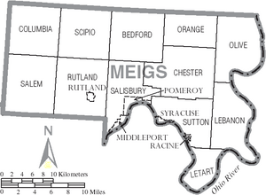
Villages
- Middleport
- Pomeroy (county seat)
- Racine
- Rutland
- Syracuse
Townships
- Bedford
- Chester
- Columbia
- Lebanon
- Letart
- Olive
- Orange
- Rutland
- Salem
- Salisbury
- Scipio
- Sutton
Census-designated place
Unincorporated communities
Notable People
Many interesting people have come from Meigs County:
- Nelson Story Sr. was born in Burlingham in 1838.
- Mike Bartrum played in the NFL as a long snapper and tight end.
- Ambrose Bierce was a journalist and writer, famous for his short stories.
- James Edwin Campbell was a poet, writer, and teacher.
- David L. "Dave" Diles was a sports broadcaster and journalist.
- Norman "Kid" Elberfeld was a Major League Baseball shortstop and manager.
- William P. Halliday was a steamboat captain and businessman.
- Ralston B. (Rollie) Hemsley was a Major League Baseball catcher.
- Samuel Dana Horton wrote about money systems.
- Reverend Fr. John Joseph Jessing started the Pontifical College Josephinum in Columbus, Ohio.
- Benny Kauff was a Major League Baseball player.
- Cy Morgan was a Major League Baseball pitcher.
See also
 In Spanish: Condado de Meigs (Ohio) para niños
 | Tommie Smith |
 | Simone Manuel |
 | Shani Davis |
 | Simone Biles |
 | Alice Coachman |


