Shade River facts for kids
Quick facts for kids Shade River |
|
|---|---|

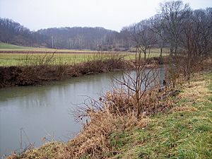
The East Branch of the Shade River in Chester Township in 2006
|
|

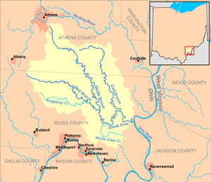
Map of the Shade River and its watershed
|
|
| Country | United States |
| State | Ohio |
| County | Meigs |
| Physical characteristics | |
| Main source | West Branch Shade River Scipio Township, Meigs County 853 ft (260 m) 39°11′28″N 82°09′24″W / 39.19111°N 82.15667°W |
| 2nd source | Middle Branch Shade River Athens Township, Athens County 950 ft (290 m) 39°18′33″N 82°04′52″W / 39.30917°N 82.08111°W |
| River mouth | Ohio River Olive Township, Meigs County 561 ft (171 m) 39°04′03″N 81°48′49″W / 39.06750°N 81.81361°W |
| Length | 17.4 mi (28.0 km) |
| Basin features | |
| Basin size | 221 sq mi (570 km2) |
| Tributaries |
|
The Shade River is a river in southeastern Ohio, United States. It is a tributary of the Ohio River, which means it's a smaller river that flows into a larger one. Through the Ohio River, its waters eventually reach the mighty Mississippi River.
The Shade River and all the land that drains into it make up its watershed. This watershed covers about 221 square miles (570 km2) of land. This area is part of the Allegheny Plateau, a hilly region that was not covered by glaciers a long time ago. The main part of the Shade River is about 17.4 miles (28.0 km) long. If you include its longest branch, the West Branch, it stretches to about 38.2 miles (61.5 km).
Contents
Where the Shade River Begins
The Shade River is special because it starts from three main streams or "branches." These are called the West Branch, Middle Branch, and East Branch. The main Shade River forms when the Middle and West Branches join together. Soon after, the East Branch also flows into it.
West Branch Shade River
- This branch starts in Scipio Township in Meigs County.
- It begins at a height of 853 feet (260 meters) above sea level.
- The West Branch flows towards the east-southeast through Bedford and Chester Townships.
- It is about 20.8 miles (33.5 km) long.
- The land area that drains into this branch is about 71.3 square miles (185 km2).
Middle Branch Shade River
- This branch begins southeast of the city of Athens in Athens County.
- It starts at a higher point, 950 feet (290 meters) above sea level.
- The Middle Branch flows southeast through several townships in Athens and Meigs Counties, including Alexander, Lodi, Carthage, Bedford, Orange, and Chester.
- It is the longest branch, measuring about 28.5 miles (45.9 km).
- Its watershed covers about 57.6 square miles (149 km2).
East Branch Shade River
- This branch starts in Lodi Township in Athens County.
- Its starting elevation is 916 feet (279 meters).
- The East Branch flows south-southeast through Carthage Township in Athens County, and Orange and Chester Townships in Meigs County.
- It is about 21.9 miles (35.2 km) long.
- The area that drains into this branch is about 54.9 square miles (142 km2).
Journey to the Ohio River
After the Middle and West Branches meet in Chester Township, the main Shade River flows generally eastward. It passes by the community of Chester. The East Branch then joins the Shade River from the north near the community of Keno. Finally, the Shade River flows into the Ohio River in Olive Township. This is about one mile (2 km) south of the community of Long Bottom.
Other Names for the River
Over time, the Shade River has been known by a couple of other names. According to the Geographic Names Information System, people have also called it "Shade Creek" and "Devils Hole Creek."
How Much Water Flows?
Scientists measure how much water flows in rivers. At a special measuring station near Chester, the Shade River's average flow between 1965 and 2012 was about 174 cubic feet per second (which is about 5 cubic meters per second).
- Highest Flow: The most water ever recorded flowing through the river was on March 2, 1997. On that day, it reached a huge 15,600 cubic feet per second (442 cubic meters per second)!
- Lowest Flow: The river has also been very low. On September 5, 2007, it was recorded with almost no flow at all, 0.00 cubic feet per second. This shows how much a river's flow can change depending on the weather and season.
 | Selma Burke |
 | Pauline Powell Burns |
 | Frederick J. Brown |
 | Robert Blackburn |

