
Jackson County, West Virginia facts for kids
Quick facts for kids
Jackson County
|
||
|---|---|---|

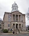
The Jackson County Courthouse in Ripley in 2007
|
||
|
||

Location within the U.S. state of West Virginia
|
||
 West Virginia's location within the U.S. |
||
| Country | ||
| State | ||
| Founded | March 1, 1831 | |
| Named for | Andrew Jackson | |
| Seat | Ripley | |
| Largest city | Ravenswood | |
| Area | ||
| • Total | 472 sq mi (1,220 km2) | |
| • Land | 464 sq mi (1,200 km2) | |
| • Water | 7.3 sq mi (19 km2) 1.5%% | |
| Population
(2020)
|
||
| • Total | 27,791 | |
| • Estimate
(2021)
|
27,738 |
|
| • Density | 58.88/sq mi (22.733/km2) | |
| Time zone | UTC−5 (Eastern) | |
| • Summer (DST) | UTC−4 (EDT) | |
| Congressional district | 1st | |

Jackson County is a county in the state of West Virginia, United States. It's located in the western part of the state. In 2020, about 27,791 people lived here.
The main town and county seat is Ripley. The biggest town in Jackson County is Ravenswood.
Contents
History of Jackson County
Early Explorers and Settlers
Long ago, in 1674, a frontiersman named Gabriel Arthur visited this area. He was probably the first European to see the large Native American village here. Later, French and British traders also came to the region.
In 1749, a French explorer named Celeron De Blainville traveled on the Ohio River. His group left special lead plates to show that France claimed this land. The next year, an explorer from Baltimore, Christopher Gist, also visited.
In 1770, when this area was still part of the Colony of Virginia, George Washington explored it. He stayed near Sand Creek at a village where Iroquois people lived. This area later became the town of Ravenswood. Washington claimed land here in 1793.
The first private school in the county opened in Cottageville in 1807. More schools followed in other towns, helping children learn and grow.
How Jackson County Was Formed
In 1831, people living here asked for a new county to be created. Jackson County was formed from parts of Kanawha, Wood, and Mason Counties. It was named after Andrew Jackson, who was the seventh President of the United States.
Ripley was chosen as the county seat in 1832. A courthouse was built there by 1833. Ravenswood was planned the next year.
Travel and trade became easier as roads were built. A ferry started operating at Ravenswood in 1840. A wagon road connected Ravenswood to Spencer in the 1840s. Much later, in 1886, the Baltimore and Ohio Railroad reached Ravenswood. By 1840, Jackson County had a population of 4,890 people.
As more people moved in, parts of Jackson County were used to create two new counties. Wirt County was formed in 1848. Then, Roane County was created in 1856.
Jackson County During the Civil War
During the American Civil War, people in Jackson County had different ideas. Most people supported the Union (the North). The county faced attacks from both sides.
One important event was the Battle of Buffington Island in July 1863. This battle happened near Ravenswood. It was the only naval battle in West Virginia. Union forces captured many Confederate soldiers, which helped stop their raids.
When West Virginia became a state in 1863, counties were divided into smaller areas called townships. These were meant to help local government. Later, in 1872, these townships became "magisterial districts." Jackson County had five of these districts. In the 1990s, they were changed into three new districts.
Growth and Development After the War
After the Civil War, Jackson County continued to grow. Many people from other parts of Virginia moved to the area.
Logging (cutting down trees for wood) and finding oil and gas helped the county's population grow. By 1900, about 19,000 people lived in Jackson County. It had a lot of farmland, mostly small farms.
In 1954, a big company called Kaiser Aluminum built a factory here. It made aluminum and became a major employer. The aluminum plant closed in 2015, but a part of it that makes aluminum sheets still operates today.
The Cedar Lakes Conference Center was also built around 1954. It's still open and hosts many events and meetings. There's also a Baptist conference center that serves many churches.
Geography of Jackson County
Jackson County covers about 472 square miles. Most of this is land (464 square miles), and a small part is water (7.3 square miles). The Ohio River forms part of the county's western border. Two important creeks, Sandy Creek and Mill Creek, flow through the county and into the Ohio River.
Main Roads in Jackson County
 Interstate 77
 U.S. Highway 33
 West Virginia Route 2
 West Virginia Route 34
 West Virginia Route 62
 West Virginia Route 68
 West Virginia Route 87
 West Virginia Route 331
Neighboring Counties
Jackson County shares borders with several other counties:
- Wood County (to the north)
- Wirt County (to the northeast)
- Roane County (to the east)
- Kanawha County (to the south)
- Putnam County (to the southwest)
- Mason County (to the west)
- Meigs County, Ohio (to the northwest, across the Ohio River)
Protected Natural Areas
Part of the Ohio River Islands National Wildlife Refuge is located in Jackson County. This refuge helps protect wildlife and their homes along the Ohio River.
People of Jackson County
| Historical population | |||
|---|---|---|---|
| Census | Pop. | %± | |
| 1840 | 4,890 | — | |
| 1850 | 6,544 | 33.8% | |
| 1860 | 8,306 | 26.9% | |
| 1870 | 10,300 | 24.0% | |
| 1880 | 16,312 | 58.4% | |
| 1890 | 19,021 | 16.6% | |
| 1900 | 22,987 | 20.9% | |
| 1910 | 20,956 | −8.8% | |
| 1920 | 18,658 | −11.0% | |
| 1930 | 16,124 | −13.6% | |
| 1940 | 16,598 | 2.9% | |
| 1950 | 15,299 | −7.8% | |
| 1960 | 18,541 | 21.2% | |
| 1970 | 20,903 | 12.7% | |
| 1980 | 25,794 | 23.4% | |
| 1990 | 25,938 | 0.6% | |
| 2000 | 28,000 | 7.9% | |
| 2010 | 29,211 | 4.3% | |
| 2020 | 27,791 | −4.9% | |
| 2021 (est.) | 27,738 | −5.0% | |
| U.S. Decennial Census 1790–1960 1900–1990 1990–2000 2010–2020 |
|||
Population Information from 2010
In 2010, there were 29,211 people living in Jackson County. There were 11,931 households, which are groups of people living together. The average number of people in each household was about 2.43. The average age of people in the county was 42.2 years.
Most people in the county were white (98.2%). A small number were black or African American (0.3%), Asian (0.3%), or American Indian (0.2%). About 0.6% of the population was of Hispanic or Latino background.
Many families in Jackson County had children under 18 living with them (30.8%). Most households were married couples living together (56.5%).
The average income for a household was about $41,406 per year. For families, the average income was about $49,395. About 18.1% of all people in the county lived below the poverty line. This included 28.0% of children under 18.
Towns and Communities


Cities in Jackson County
- Ravenswood
- Ripley (This is the county seat, where the main county government offices are.)
Magisterial Districts
These are areas within the county used for local government.
Current Districts
- Eastern
- Northern
- Western
Historic Districts
- Grant
- Ravenswood
- Ripley
- Union
- Washington
Former Town
Small Communities (Unincorporated)
These are smaller towns or areas that don't have their own city government.
Images for kids
-
The Jackson County Courthouse in Ripley in 2007
See also
 In Spanish: Condado de Jackson (Virginia Occidental) para niños
