Mill Creek (western West Virginia) facts for kids
Quick facts for kids Mill Creek |
|
|---|---|

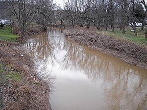
Mill Creek in Ripley in 2007
|
|

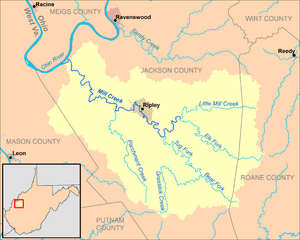
Map of Mill Creek and its watershed
|
|
| Country | United States |
| State | West Virginia |
| Physical characteristics | |
| Main source | Elk Fork western Roane County 1,021 ft (311 m) 38°45′18″N 81°28′55″W / 38.75500°N 81.48194°W |
| 2nd source | Little Mill Creek northwestern Roane County 976 ft (297 m) 38°49′15″N 81°29′36″W / 38.82083°N 81.49333°W |
| River mouth | Ohio River Millwood 554 ft (169 m) 38°53′04″N 81°51′43″W / 38.88444°N 81.86194°W |
| Length | 29.4 mi (47.3 km) |
| Basin features | |
| Basin size | 234 sq mi (610 km2) |
| Tributaries |
|
Mill Creek is a stream in West Virginia, United States. It flows into the Ohio River. The creek is about 29.4 miles (47.3 km) long. It is part of a larger water system that eventually reaches the Mississippi River. This system drains an area of 234 square miles (606 km²) on the Allegheny Plateau. Mill Creek has also been called Big Mill Creek in the past.
Contents
Where Mill Creek Begins
Mill Creek starts in Jackson County. It forms about 4 miles (6.4 km) east of the city of Ripley. Two smaller streams join together to create Mill Creek. These streams are called the Elk Fork and Little Mill Creek.
Elk Fork
The Elk Fork is about 15.4 miles (24.8 km) long. It begins in the western part of Roane County. This stream flows mostly towards the northwest.
Little Mill Creek
Little Mill Creek is about 11.1 miles (17.9 km) long. It starts in the northwestern part of Roane County. This stream flows mainly towards the west.
Tug Fork Joins In
Soon after Elk Fork and Little Mill Creek meet, another stream joins Mill Creek. This stream is called the Tug Fork. It is about 11.9 miles (19.2 km) long. Tug Fork starts in southern Jackson County. It forms where two smaller streams, Bear Fork and Grasslick Creek, come together. Tug Fork flows northwest past the community of Statts Mills. It then joins Mill Creek from the south.
Mill Creek's Journey
Mill Creek flows in a winding path through central and western Jackson County. It passes through the city of Ripley. Some people believe Ripley was named after Harry Ripley. He was a traveling preacher who is said to have drowned in the creek in 1830.
After Ripley, the creek flows through a wide valley. This area is near the community of Cottageville. Finally, Mill Creek flows into the Ohio River at the community of Millwood.
Backwater and Port
The last 6 miles (9.7 km) of Mill Creek are affected by the Ohio River. This part is called "backwater." It means the water level is higher because of dams on the Ohio River. There is also a commercial port facility near where the creek meets the Ohio River. This port handles materials like limestone, sand, gravel, aluminum, and salt.
Land Around Mill Creek
The land around Mill Creek is mostly covered by forests. About 74% of the area is forested. Most of these are deciduous trees, which lose their leaves in the fall. About 25% of the land is used for farming and pastures for animals. Less than 1% of the area is covered by towns or cities.
 | Claudette Colvin |
 | Myrlie Evers-Williams |
 | Alberta Odell Jones |

