Sandy Creek (Ohio River tributary) facts for kids
Quick facts for kids Sandy Creek |
|
|---|---|

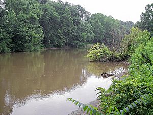
Sandy Creek near its mouth in Ravenswood in 2006
|
|

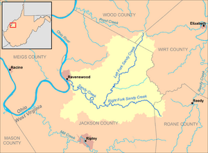
Map of Sandy Creek and its watershed
|
|
| Country | United States |
| State | West Virginia |
| County | Jackson |
| Physical characteristics | |
| Main source | Left Fork Sandy Creek South of Rockport, southeastern Wood County 1,014 ft (309 m) 39°02′54″N 81°33′37″W / 39.04833°N 81.56028°W |
| 2nd source | Right Fork Sandy Creek northwestern Roane County 879 ft (268 m) 38°52′22″N 81°30′27″W / 38.87278°N 81.50750°W |
| River mouth | Ohio River Ravenswood, West Virginia 564 ft (172 m) 38°56′43″N 81°45′42″W / 38.94528°N 81.76167°W |
| Length | 22 mi (35 km) |
| Basin features | |
| Basin size | 124 sq mi (320 km2) |
Sandy Creek is a river in western West Virginia, United States. It flows into the Ohio River. The Ohio River then joins the mighty Mississippi River. This means Sandy Creek is part of the huge Mississippi River system. It helps drain an area of about 124 square miles (321 square kilometers). This area is part of the Allegheny Plateau. The creek is about 22 miles (35 kilometers) long. If you include its longest branch, the Left Fork, it's about 38.3 miles (61.6 kilometers) long.
Contents
About Sandy Creek
Sandy Creek is an important waterway in West Virginia. It collects water from a large area of land. This land is called its watershed. The creek's waters eventually travel all the way to the Gulf of Mexico. This happens because it connects to the Ohio River and then the Mississippi River.
Where Sandy Creek Starts
Sandy Creek actually begins when two smaller streams meet. These streams are called its "forks." They come together in the northern part of Jackson County.
The Left Fork
The Left Fork Sandy Creek is about 16.3 miles (26.2 kilometers) long. It starts near a place called Rockport. This is in the southeastern part of Wood County. It flows south through parts of Wirt County and into Jackson County. Along its path, it passes through small towns like Wiseburg and Sandyville. An old highway, once U.S. Route 21, runs alongside much of this fork.
The Right Fork
The Right Fork Sandy Creek is about 11.7 miles (18.8 kilometers) long. It begins about 5 miles (8 kilometers) west of Reedy. This area is in the northwestern part of Roane County. This fork generally flows west into Jackson County. It goes through communities such as Liverpool and LeRoy.
Sandy Creek's Journey to the Ohio River
After the Left and Right Forks join, Sandy Creek flows west-northwest. It passes through the town of Silverton. Finally, it reaches Ravenswood. Here, Sandy Creek empties into the Ohio River from the east side.
The Land Around the Creek
The land that drains into Sandy Creek is mostly covered by forests. About 80% of the watershed is forested. Most of these are deciduous trees, which lose their leaves in the fall. About 19% of the land is used for farms and pastures. Less than 1% of the area is covered by cities or towns.
Historical Names
Over time, Sandy Creek has been known by other names. It was sometimes called Big Sandy Creek. Another historical name was Buffalo Creek. A report from 1906 even recorded a name from a Native American language: Mol-chu-con-ic-kon.
 | Georgia Louise Harris Brown |
 | Julian Abele |
 | Norma Merrick Sklarek |
 | William Sidney Pittman |

