Seven Ranges facts for kids
The Seven Ranges was a special area of land in eastern Ohio. It was the very first part of land in the United States to be measured and mapped out in a system called the Public Land Survey System. This system helped the country organize and sell land as it grew.
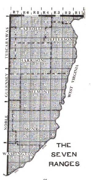
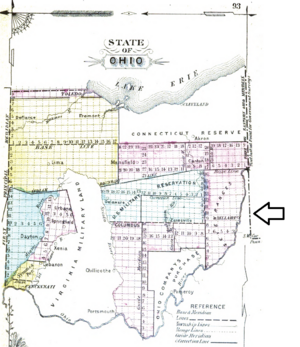
The Seven Ranges area is about 42 miles (68 km) wide at the top. It stretches about 91 miles (146 km) down its western side. The south and east edges follow the Ohio River. This land includes all of Monroe, Harrison, Belmont, and Jefferson counties. It also covers parts of Carroll, Columbiana, Tuscarawas, Guernsey, Noble, and Washington County.
Contents
How the Land Was Claimed and Organized
After the American Revolutionary War ended in 1783, the United States claimed the land north of the Ohio River. Before this, Great Britain had taken the land from France in 1763. Britain had also made a rule, the Royal Proclamation of 1763, saying white settlers could not move there.
Even with this rule, some people moved into the area without permission. They settled in places like Tiltonsville and Martins Ferry. The government had to remove them by force.
The Land Ordinance of 1785
To manage the land properly, the U.S. Congress passed the Land Ordinance of 1785. This law created a formal way to survey, sell, and settle the land. It also helped the government make money.
The law said land should be measured into square areas called "townships." Each township was six miles (9.656 km) on each side. These townships were arranged in rows running north-south, called "ranges."
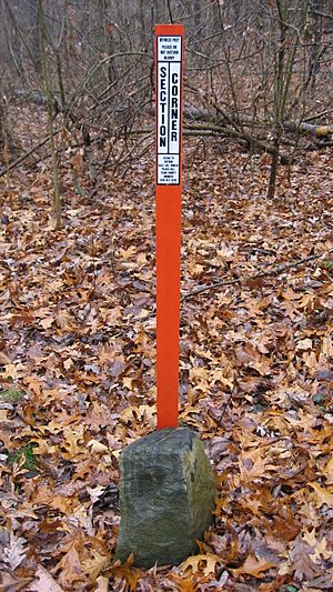
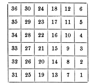
Each township was then divided into 36 smaller squares called "sections." Each section was one square mile (2.59 km²) or 640 acres. These ranges, townships, and sections were all given numbers in a specific order.
Starting the Survey: Key Lines
The first north-south line for surveying was called the Eastern Ohio Meridian. This line was the western border of Pennsylvania. It was sometimes called Ellicott's Line after Andrew Ellicott, who helped survey it.
The first east-west line was called the Geographer's Line or Base Line. It started where the Pennsylvania border touched the north bank of the Ohio River. This spot is known as the Beginning Point of the U.S. Public Land Survey 40°38′33″N 80°31′10″W / 40.64250°N 80.51944°W. The Geographer's Line was meant to go west across all the territory between the Ohio River and Lake Erie.
Selling the Land
The Geographer of the United States, Thomas Hutchins, was in charge of the survey. After each seven ranges were mapped, he would report his findings. The Secretary of War would then choose one-seventh of the land to give to veterans of the Continental Army.
The rest of the land was sold at auctions in New York, which was the nation's capital at the time. The smallest piece of land you could buy was one section (one square mile or 640 acres). Some townships were sold whole. The minimum price was one dollar per acre, paid in cash or land warrants. No land was sold on credit.
The First Surveyors
The 1785 law said that one surveyor from each state should be chosen by Congress. Here are some of the first surveyors:
- New Hampshire: Winthrop Sargent
- Massachusetts: Benjamin Tupper
- Rhode Island: Ebenezer Sproat
- New York: William Morris
- Pennsylvania: Adam Hoopes
- Maryland: James Simpson
- Virginia: Alex Parker
- North Carolina: Absalom Tatom
- South Carolina: William Tate
- Connecticut: Isaac Sherman
The Survey Process
Starting the Work
After the law passed, Thomas Hutchins received money and made plans. He arrived in Pittsburgh on September 3, 1785. He wrote to Congress, explaining that it was hard to make perfect square townships on a round Earth.
Hutchins began surveying the Geographer's Line on September 30. But on October 8, they heard about a Native American attack nearby. Hutchins and his team were scared. They returned to Pittsburgh after only surveying a few miles. Hutchins then went back to New York that autumn.
On May 9, 1786, Congress told Hutchins to only survey south of the Geographer's Line. This was because the exact location of the 41st line of latitude, which was the northern border of the Congress Lands, was not yet decided.
Completing the Lines
Hutchins returned to Pittsburgh on July 25, 1786. He and his team started surveying again on August 5. By September 1786, they finished the Geographer's Line. They placed a stone marker near Magnolia, at a spot called the Seven Ranges Terminus 40°39′07″N 81°19′05″W / 40.65194°N 81.31806°W.
With protection from soldiers at the new Fort Steuben, the team completed four ranges that autumn. They also surveyed 42 miles of the west side of the fifth range. Hutchins sent a map of the first four ranges to Congress in the spring of 1787.
Hutchins took a break in June 1787. Other surveyors continued the work. Israel Ludlow finished the seventh range. Its southwest corner 39°20′33″N 81°21′52″W / 39.34250°N 81.36444°W was a few miles up the Ohio River from Marietta, Ohio. James Simpson finished the sixth range, and Absalom Martin finished the fifth.
These three surveyors returned to New York and completed their report with Hutchins. Hutchins submitted the final plan and maps on July 26, 1788. He started surveying more land on September 2, 1788, but became ill. He returned to Pittsburgh and died on April 28, 1789, before finishing his work.
The first survey placed markers every mile (1.6 km) along the four sides of each township. They did not survey the inside of the townships. The individual sections were not fully surveyed until 1806.
How Townships and Sections Were Numbered
The sections within each township were numbered according to the 1785 Land Ordinance plan. The Ranges were numbered starting from Ellicott's Line and moving westward.
Townships were numbered starting from the southernmost township in each range and going northward toward the Geographer's Line. This system was called the Ohio River Base. Because the Ohio River curves, townships next to each other did not always have the same number. For example, the townships next to the Geographer's Line were numbered 5, 9, 12, 13, 14, 15, and 16 in ranges 1 to 7. This numbering issue was fixed in later surveys outside of Ohio.
Selling the Land to Settlers
Public land sales began in 1787 in New York. They later continued in Philadelphia, Pittsburgh, and Steubenville, Ohio. It was difficult for people to settle in the area because of ongoing conflicts with Native Americans. These conflicts continued until the Treaty of Greenville in 1795. Because of this, settlement was slow.
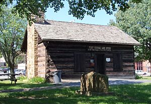
Steubenville was founded in 1797. The Federal Land Office there opened in 1801. This office was in charge of selling land in the northern part of the Seven Ranges. This included land within 48 miles (77 km) of the Geographer's Line. The Marietta Land Office sold land in the southern part. The General Land Office in the nation's capital also sold land. Eventually, the local offices closed.
Most of the people who settled in the Seven Ranges came from Pennsylvania and Virginia.
Land for Education and Future Sales
An important part of the Land Ordinance of 1785 was setting aside Section 16 of every township for public education. These were called School Lands.
Congress also kept Sections 8, 11, 26, and 29 in every township for future sale. They hoped these lands would sell for higher prices later, once the areas around them were developed. The government also claimed one-third of all gold, silver, lead, and copper mines. This was a hopeful idea, as there weren't many such mines in Ohio.
Special Land Grants
Dohrman Tract
Arnold Henry Dohrman helped the American cause during the Revolutionary War. He spent a lot of his own money while living in Portugal. Since Congress could not pay him back fully, they gave him Township 13 of Range 7. This area became known as the Dohrman Tract or Dohrman's Grant. Today, it is part of Harrison and Tuscarawas Counties.
Ephraim Kimberly Grant
The Ephraim Kimberly Grant was a 300-acre (1.2 km2) piece of land. It was in Township 4 of Range 2 of the Seven Ranges. Congress gave this land to an American Revolutionary War veteran named Ephraim Kimberly in the late 1700s.
What We Learned from the Seven Ranges
The original plan was to send maps back to Congress after every seven ranges were surveyed. But this plan was only followed for the first Seven Ranges.
The system of numbering sections from 1785 was later used for other privately surveyed lands, like the Symmes Purchase and the Ohio Company of Associates. However, a different system was created for surveys that came after these.
The way townships were numbered north from the Ohio River Base, and ranges west from Pennsylvania, was also used for the Ohio Company of Associates, Congress Lands North of Old Seven Ranges, and Congress Lands East of Scioto River.
A point on the western border of the Seven Ranges, fifty miles south of the Geographer's Line, became the starting point for the United States Military District survey.
 | Lonnie Johnson |
 | Granville Woods |
 | Lewis Howard Latimer |
 | James West |


