Congress Lands North of Old Seven Ranges facts for kids
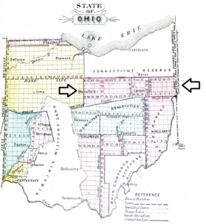
The Congress Lands North of the Old Seven Ranges was a special area of land in northeast Ohio. The United States government, also known as Congress, set up this land in the early 1800s. It was located in a specific spot: south of the Connecticut Western Reserve and Firelands, east of the Congress Lands South and East of the First Principal Meridian, north of the United States Military District and Seven Ranges, and west of Pennsylvania.
Contents
History of the Land
After the American Revolutionary War, the United States claimed a large area called the Ohio Country. Before that, Great Britain had taken this land from France in 1763. For a while, white settlers were not allowed to move there.
To help settle the land and raise money, the government passed a law in 1785. It was called the Land Ordinance of 1785. This law created a system for surveying, selling, and settling new lands.
How Land Was Measured
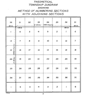
The land was measured into square areas called "townships". Each township was six miles (about 9.6 kilometers) on each side. These townships were arranged in rows called "ranges." Each township was then divided into 36 smaller squares called "sections". Each section was one square mile (about 2.59 square kilometers) or 640 acres. All these ranges, townships, and sections were given numbers.
The first north-south line for measuring was the Eastern Ohio Meridian. This line was the western border of Pennsylvania. It was sometimes called Ellicott's Line. The first east-west line was called the Geographer's Line or Base Line. It started where the Pennsylvania border met the Ohio River. This spot is known as the Beginning Point of the U.S. Public Land Survey.
Early Surveys and Claims
There was a challenge because Connecticut claimed land north of the 41st parallel latitude. So, in 1786, the government told its surveyor, Thomas Hutchins, to only survey south of the Geographer's Line. By 1787, Hutchins' team finished surveying seven ranges. This area became known as the Seven Ranges.
Later, in 1796, the government created the United States Military District. This area was west of the Old Seven Ranges. It was also south of a boundary line set by the Treaty of Greenville.
The Survey of Congress Lands
There was still a large area of land in eastern Ohio that hadn't been surveyed. This land was north of the Seven Ranges and the Military District. It was also south of the Connecticut Western Reserve.
First Survey (1801)
This gap of land stretched from the Pennsylvania border to the Tuscarawas River. Around 1801, this area was surveyed. The ranges and townships followed the same numbering system as the original Seven Ranges. Ranges were numbered from west of Pennsylvania. Townships within each range were numbered from south to north, starting at the Ohio River. This meant townships next to each other might have different numbers. Sections were numbered using the 1796 system.
Second Survey (1806-1807)
The Treaty of Greenville in 1795 had set aside land west of the Tuscarawas River for Native American tribes. This land was not open for American settlement yet. However, in 1805, a new agreement called the Treaty of Fort Industry changed things. Six Native American tribes gave up land west of the Tuscarawas River. This land was between Lake Erie and the Greenville Treaty Line.
The government surveyed these new lands in 1806 and 1807. This survey also used six-mile square townships. It continued the same numbering system for ranges, townships, and sections.
The two surveys from 1801 and 1806-1807 together became known as the Congress Lands North of the Old Seven Ranges.
Muskingum River Survey
This small part of the Congress Lands North of the Old Seven Ranges includes only two townships. They are numbered 1 and 2 north. They are in range 10 west. This range continues the numbering from the Ohio River Survey. This survey happened in 1800. Today, Lawrence Township, Stark County, Ohio and Franklin Township, Summit County, Ohio are in this area.
Selling the Land
At first, land between the Seven Ranges and the Western Reserve was sold in Pittsburgh. In 1800, the Steubenville Federal Land Office was set up to sell these lands.
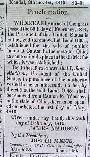
Later, in 1807, a new land office was created for the Congress Lands North of Old Seven Ranges. This office ended up in Canton, Ohio. It was called the Canton Land District. In 1811, the office moved to Wooster, Ohio, but it kept the name Canton Land District. Land was also sold from the nation's capital at the General Land Office. Eventually, these local offices closed. The State of Ohio also sold lands that the federal government gave to them. For example, section 16 of each township was often set aside for schools.
Today's Counties
Today, this historic land tract covers all or parts of several counties in Ohio. These include Ashland, Carroll, Columbiana, Crawford, Holmes, Knox, Mahoning, Morrow, Richland, Stark, Summit, and Wayne.
 | Percy Lavon Julian |
 | Katherine Johnson |
 | George Washington Carver |
 | Annie Easley |


