The Firelands (also known as the Sufferers' Lands) is a special area in what is now the U.S. state of Ohio. It's found at the western edge of the Connecticut Western Reserve. This land was officially created in 1792. It was called "Fire Lands" because it was meant to help people whose homes were burned. British forces destroyed their towns in Connecticut during the American Revolutionary War in 1779 and 1781. These towns included Danbury, Fairfield, Greenwich, Groton, New Haven, New London, Norwalk, and Ridgefield. Most people didn't start settling in the Firelands until after the War of 1812. The name "Fire Lands" later became one word: "Firelands."
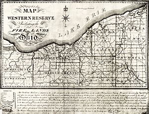
Map of the Western Reserve in 1826: the Firelands are on the west end (left).
How the Firelands Began
In 1792, the government of Connecticut set aside 500,000 acres (about 2,000 square kilometers) of land. This land was at the western end of the "Western Reserve." It was meant for the "Sufferers" from Connecticut. The area includes most of today's Huron and Erie counties. It also includes Danbury Township and much of Catawba Island Township in Ottawa County. Plus, it has Ruggles Township in Ashland County. Even though the land was set aside in 1792, people didn't really start moving there until around 1807.
Land Division and Early Settlers
It's not known if any of the original "Sufferers" actually moved to the Firelands. Before anyone settled there, land investors bought all the original claims. They planned to sell the land again. On April 15, 1803, these investors formed a company to manage the land. This was in the newly formed state of Ohio.
The land was later divided into 30 square areas called survey townships. Each township was five miles (about 8 kilometers) wide. These townships were then split into 120 smaller parts. Each part contained about 4,000 acres (16 square kilometers). A special drawing was held to decide which land each investor would receive. Some of the first townships in the Firelands were named after places in Connecticut. Others were named after the land investors who bought them. Later, after the War of 1812, many new villages were also named after Connecticut towns.
Developing the Firelands
In 1811, Huron County covered the entire Firelands area. It also included a part of what later became Lorain County. Until 1837, all of the Firelands was part of Huron County.
Today, signs in this area show the "established 1792" date. The land was officially measured and mapped between 1806 and 1808. People began to settle there slowly after 1808. No villages really grew in the Firelands until after the War of 1812 ended.
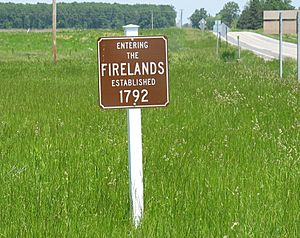
Firelands sign along Ohio State Route 4 in Sherman Township, Huron County, Ohio.
Cities and Towns in the Firelands
Many cities and towns are located within the historic Firelands area. These places are spread across several counties in Ohio.
Townships in the Firelands
The Firelands also includes many townships. These are smaller local government areas.
|
|
| Erie County |
| Berlin |
| Florence |
| Groton |
| Huron |
| Margaretta |
| Milan |
| Oxford |
| Perkins |
| Vermilion |
|
| Huron County |
|
| Bronson |
Norwalk |
| Clarksfield |
Norwich |
| Fairfield |
Peru |
| Fitchville |
Richmond |
| Greenfield |
Ridgefield |
| Greenwich |
Ripley |
| Hartland |
Sherman |
| Lyme |
Townsend |
| New Haven |
Wakeman |
| New London |
|
|
Unincorporated Communities
There are also many smaller communities in the Firelands that are not officially part of a city or township.
| Ashland County |
| Hereford |
| Ruggles |
|
|
| Huron County |
|
| Bismarck |
Huron Junction |
| Boughtonville |
Myers Mills |
| Celeryville |
New Haven |
| Centerton |
New Pittsburgh |
| Clarksfield |
North Monroeville (part) |
| Collins |
Olena |
| Delphi |
Peru Hollow |
| East Norwalk |
Phoenix Mills |
| East Townsend |
Pontiac |
| Fitchville |
Standardsburg |
| Guinea Corners |
Steuben |
| Hanville Corners |
Strongs Ridge |
| Hartland |
Weavers Corners |
| Hartland Station |
West Clarksfield |
| Havana |
West Hartland |
| Holiday Lakes |
White Fox |
| Hunts Corners |
|
| Ottawa County |
| Danbury |
| Harbor Acres |
| Lakeside |
| Mineyahta-on-the-Bay |
|


