Lorain County, Ohio facts for kids
Quick facts for kids
Lorain County
|
|||
|---|---|---|---|

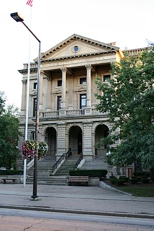
Old county building in Elyria
|
|||
|
|||

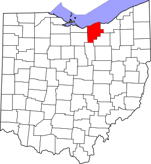
Location within the U.S. state of Ohio
|
|||
 Ohio's location within the U.S. |
|||
| Country | |||
| State | |||
| Founded | April 1, 1824 | ||
| Named for | Lorraine in France | ||
| Seat | Elyria | ||
| Largest city | Lorain | ||
| Area | |||
| • Total | 923 sq mi (2,390 km2) | ||
| • Land | 491 sq mi (1,270 km2) | ||
| • Water | 432 sq mi (1,120 km2) 47%% | ||
| Population
(2020)
|
|||
| • Total | 312,964 | ||
| • Estimate
(2023)
|
317,910 |
||
| • Density | 339.07/sq mi (130.92/km2) | ||
| Congressional district | 5th | ||
Lorain County is a cool place located in the northeastern part of Ohio. It's a county, which is like a big area with its own local government. In 2020, about 312,964 people lived here. The main city where the county government is located is Elyria, and the biggest city is Lorain. Lorain County was officially created in 1822 and started working independently in 1824. It's also part of the larger Cleveland area. You can find Oberlin College, a famous school, right here in the county!
Contents
History of Lorain County
Lorain County was created in 1822. It was made from parts of other counties nearby. The county started working on its own in 1824.
At first, people thought about naming it "Colerain." But then, Heman Ely chose the name "Lorain." He was the person who founded and named the city of Elyria. The name "Lorain" comes from a region in France called Lorraine.
Geography and Location
Lorain County is a pretty big area! It covers about 923 square miles. A large part of this area, about 432 square miles, is water. This means almost half of the county (47%) is covered by water. It is the fourth-largest county in Ohio by total area.
Counties Next to Lorain County
- Cuyahoga County (east)
- Medina County (southeast)
- Ashland County (south)
- Huron County (southwest)
- Erie County (northwest)
Main Roads and Highways
Many important roads run through Lorain County. These roads help people travel around the county and to other parts of Ohio.
 Interstate 80 (Ohio Turnpike)
 Interstate 90 (Ohio Turnpike)
 Interstate 480
 U.S. Route 6
 U.S. Route 20
 State Route 2
 State Route 10
 State Route 18
 State Route 57
 State Route 58
 Ohio Route 82
 Ohio Route 83
 State Route 113
 Ohio Route 162
 Ohio Route 252
 Ohio Route 254
 Ohio Route 301
 Ohio Route 303
 Ohio Route 511
 Ohio Route 611
People of Lorain County
| Historical population | |||
|---|---|---|---|
| Census | Pop. | %± | |
| 1830 | 5,696 | — | |
| 1840 | 18,467 | 224.2% | |
| 1850 | 26,086 | 41.3% | |
| 1860 | 29,744 | 14.0% | |
| 1870 | 30,308 | 1.9% | |
| 1880 | 35,526 | 17.2% | |
| 1890 | 40,295 | 13.4% | |
| 1900 | 54,857 | 36.1% | |
| 1910 | 76,037 | 38.6% | |
| 1920 | 90,612 | 19.2% | |
| 1930 | 109,206 | 20.5% | |
| 1940 | 112,390 | 2.9% | |
| 1950 | 148,162 | 31.8% | |
| 1960 | 217,500 | 46.8% | |
| 1970 | 256,843 | 18.1% | |
| 1980 | 274,909 | 7.0% | |
| 1990 | 271,126 | −1.4% | |
| 2000 | 284,664 | 5.0% | |
| 2010 | 301,356 | 5.9% | |
| 2020 | 312,964 | 3.9% | |
| 2023 (est.) | 317,910 | 5.5% | |
| U.S. Decennial Census 1790-1960 1900-1990 1990-2000 2010-2020 |
|||
In 2010, about 301,356 people lived in Lorain County. There were over 116,000 homes. Many families lived together, and some homes had children under 18. The average age of people in the county was 40 years old.
Education in Lorain County
Lorain County has many schools and colleges. This helps students learn and grow.
Colleges and Universities
- Lorain County Community College, Elyria
- Oberlin College, Oberlin
Public School Districts
There are 20 public school districts in Lorain County. Here are some of the main ones:
- Amherst Exempted Village School District
- Amherst Marion L. Steele High School, Amherst
- Avon Local School District
- Avon High School, Avon
- Avon Lake City School District
- Avon Lake High School, Avon Lake
- Black River Local School District (also in Medina Co and Ashland Co.)
- Black River High School, Sullivan
- Clearview Local School District
- Clearview High School, Lorain
- Columbia Local School District
- Columbia High School, Columbia Station
- Elyria City School District
- Elyria High School, Elyria
- Firelands Local School District (also in Erie Co.)
- Firelands High School, Henrietta Twp (Oberlin)
- Keystone Local School District
- Keystone High School, LaGrange
- Lorain City School District
- Lorain High School, Lorain
- Mapleton Local School District (Primarily in Ashland Co.)
- Mapleton High School, Ashland
- Midview Local School District
- Midview High School, Eaton Twp (Grafton)
- New London Local School District (primarily in Huron Co.)
- New London High School, New London
- North Ridgeville City School District
- North Ridgeville High School, North Ridgeville
- Oberlin City School District
- Oberlin High School, Oberlin
- Olmsted Falls City Schools (primarily in Cuyahoga Co.)
- Olmsted Falls High School, Olmsted Falls
- Sheffield-Sheffield Lake City School District
- Brookside High School, Sheffield
- Strongsville City School District (primarily in Cuyahoga Co.)
- Strongsville High School, Strongsville
- Vermilion Local Schools (primarily in Erie Co.)
- Vermilion High School, Vermilion
- Wellington Exempted Village School District (also in Huron Co.)
- Wellington High School, Wellington
The county also has the Lorain County Joint Vocational School District. This school helps students from many districts learn special job skills. It is located near Oberlin.
Private High Schools
- Elyria Catholic High School, Elyria
- Lake Ridge Academy, North Ridgeville
- Open Door Christian School, Elyria
- Christian Community School, North Eaton
- First Baptist Christian School, Elyria
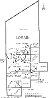
Communities in Lorain County
Lorain County is home to many different towns and cities. Each one has its own unique feel!
Cities
Villages
Townships
- Amherst
- Brighton
- Brownhelm
- Camden
- Carlisle
- Columbia
- Eaton
- Elyria
- Grafton
- Henrietta
- Huntington
- LaGrange
- New Russia
- Penfield
- Pittsfield
- Rochester
- Sheffield
- Wellington
Census-Designated Places
These are special areas that are like towns but don't have their own local government.
Unincorporated Communities
These are smaller places that are not officially cities or villages.
- Belden
- Brentwood Lake
- Brighton
- Columbia Hills Corners
- Columbia Station
- Henrietta
- North Eaton
- Pittsfield
- Whiskyville
See also
 In Spanish: Condado de Lorain para niños
 | Sharif Bey |
 | Hale Woodruff |
 | Richmond Barthé |
 | Purvis Young |


